Mayna elevation
Mayna (Khakasiya Republic), Russia elevation is 317 meters and Mayna elevation in feet is 1040 ft above sea level [src 1]. Mayna is a populated place (feature code) with elevation that is 118 meters (387 ft) bigger than average city elevation in Russia.
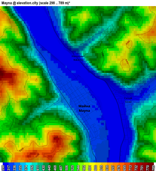
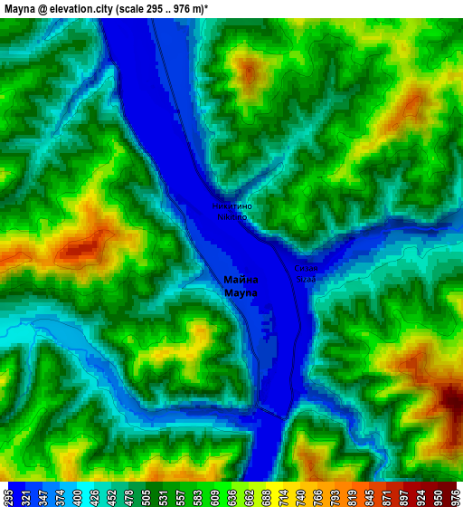
Below is the Elevation map of Mayna, which displays elevation range with different colors. Scale of the first map is from 298 to 789 m (978 to 2589 ft) with average elevation of 448.9 meters (=1473 ft) [note 1]
These maps also provides idea of topography and contour of this city, they are displayed at different zoom levels. More info about maps, scale and edge coordinates you can find below images.
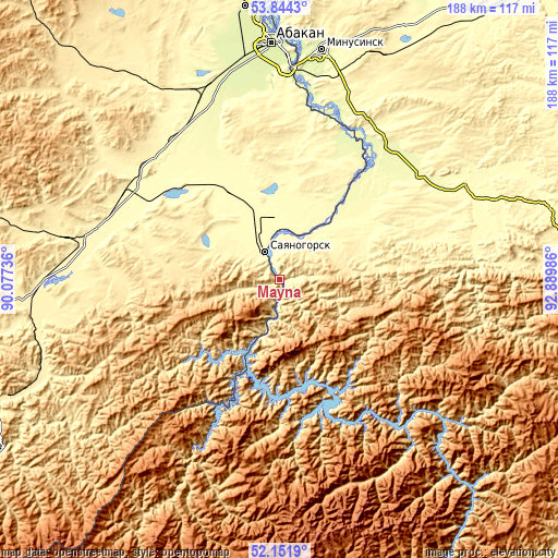
| \ | Map #1 | Map #2 | Topo.Map |
| Scale [m] | 298..789 m | 295..976 m | × |
| Scale [ft] | 978..2589 ft | 968..3202 ft | × |
| Average | 448.9 m = 1473 ft | 513.9 m = 1686 ft | × |
| Width | 5.88 km = 3.7 mi | 11.76 km = 7.3 mi | 188.2 km = 116.9 mi |
| Height | 5.88 km = 3.7 mi | 11.76 km = 7.3 mi | 188.2 km = 116.9 mi |
| ↑Max Latitude | 53.032825° | 53.059244° | 53.8443° |
| Latitude at center | 53.00639° | 53.00639° | 53.00639° |
| ↓Min Latitude | 52.979939° | 52.953472° | 52.1519° |
| ← Min Longitude | 91.439665° | 91.395719° | 90.07736° |
| Longitude center | 91.48361° | 91.48361° | 91.48361° |
| →Max Longitude | 91.527555° | 91.571501° | 92.88986° |
Nearby cities:
Cities around Mayna sort by population:
• Abakan elevation 248 m
78.9 km,  357°
357°
• Sayanogorsk 320 m
10.6 km,  328°
328°
• Shushenskoye 278 m
46.5 km,  40°
40°
• Cherëmushki 381 m
17.3 km,  194°
194°
• Belyy Yar 258 m
66.7 km,  354°
354°
• Yermakovskoye 298 m
68.1 km,  63°
63°
• Askiz 346 m
65.5 km,  282°
282°
• Beya 442 m
38.5 km, 277°
• Askiz 366 m
72 km, 281°
• Podsineye 251 m
73.4 km,  2°
2°
• Zelënyy Bor 269 m
69 km,  7°
7°
• Il’ichevo 280 m
38.5 km, 38°
Multilingual:
 En español:
Mayna elevación 317 m.
 En France:
Mayna élévation 317 m.


Sources and notes:
- [note 1] Map square and city borders are not equal. Map elevation data is calculated only from area inside that square.
- [src 1] Elevation data from geonames database provided with same terms of usage.
- [src 2] The elevation map of Mayna is generated using elevation data from NASA's 3 arcsec (90m) resolution SRTM data.
- [src 3] Base (background) map © OpenStreetMap contributors tiles are generated by Geofabrik and OpenTopoMap.
Copyright & License:
This Mayna Elevation Map is licensed under CC BY-SA. You may reuse any part from this page, if you give a proper credit by linking to this URL:
 More info on terms of use page.