Berëzovka elevation
Berëzovka (Altai Krai), Russia elevation is 214 meters and Berëzovka elevation in feet is 702 ft above sea level [src 1]. Berëzovka is a populated place (feature code) with elevation that is 15 meters (49 ft) bigger than average city elevation in Russia.
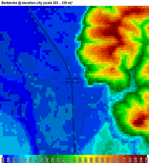
Below is the Elevation map of Berëzovka, which displays elevation range with different colors. Scale of the first map is from 203 to 339 m (666 to 1112 ft) with average elevation of 234.8 meters (=770 ft) [note 1]
These maps also provides idea of topography and contour of this city, they are displayed at different zoom levels. More info about maps, scale and edge coordinates you can find below images.
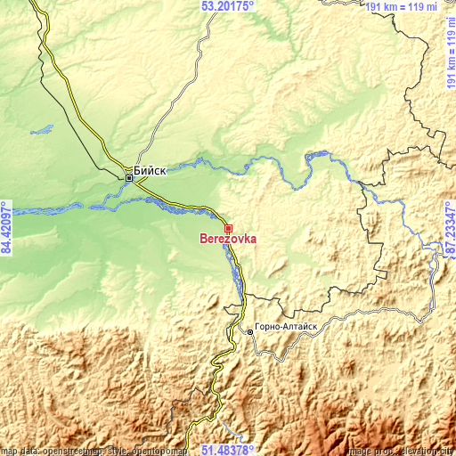
| \ | Map #1 | Topo.Map |
| Scale [m] | 203..339 m | × |
| Scale [ft] | 666..1112 ft | × |
| Average | 234.8 m = 770 ft | × |
| Width | 5.97 km = 3.7 mi | 191 km = 118.7 mi |
| Height | 5.97 km = 3.7 mi | 191 km = 118.7 mi |
| ↑Max Latitude | 52.377945° | 53.20175° |
| Latitude at center | 52.35111° | 52.35111° |
| ↓Min Latitude | 52.324259° | 51.48378° |
| ← Min Longitude | 85.783275° | 84.42097° |
| Longitude center | 85.82722° | 85.82722° |
| →Max Longitude | 85.871165° | 87.23347° |
Nearby cities:
Cities around Berëzovka sort by population:
• Mayma elevation 252 m
37.7 km,  171°
171°
• Krasnogorskoye 255 m
25.9 km,  103°
103°
• Sovetskoye 207 m
29 km,  255°
255°
• Srostki 209 m
11.6 km,  311°
311°
• Verkh-Katunskoye 192 m
29 km,  292°
292°
• Bystryanka 222 m
7.2 km,  179°
179°
• Usyatskoye 183 m
24.5 km,  349°
349°
• Ust’-Isha 244 m
21.1 km,  153°
153°
• Krasnyy Yar 181 m
33.2 km,  271°
271°
• Novikovo 203 m
31.5 km,  17°
17°
• Stan-Bekhtemir 198 m
31.5 km,  334°
334°
• Shul’gin Log 243 m
20.2 km, 174°
Multilingual:
 En español:
Berëzovka elevación 214 m.
 En France:
Berëzovka élévation 214 m.
 Auf Deutsch:
Berëzovka höhe über dem Meeresspiegel ist 214 m.
 На русском:
Березовка, Берёзовка высота над уровнем моря 214 м
Sources and notes:
- [note 1] Map square and city borders are not equal. Map elevation data is calculated only from area inside that square.
- [src 1] Elevation data from geonames database provided with same terms of usage.
- [src 2] The elevation map of Berëzovka is generated using elevation data from NASA's 3 arcsec (90m) resolution SRTM data.
- [src 3] Base (background) map © OpenStreetMap contributors tiles are generated by Geofabrik and OpenTopoMap.
Copyright & License:
This Berëzovka Elevation Map is licensed under CC BY-SA. You may reuse any part from this page, if you give a proper credit by linking to this URL:
 More info on terms of use page.