Shul’gin Log elevation
Shul’gin Log (Altai Krai), Russia elevation is 243 meters and Shul’gin Log elevation in feet is 797 ft above sea level [src 1]. Shul’gin Log is a populated place (feature code) with elevation that is 44 meters (144 ft) bigger than average city elevation in Russia.
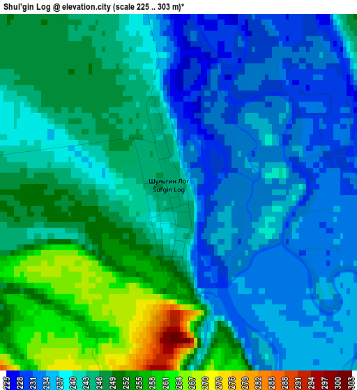
Below is the Elevation map of Shul’gin Log, which displays elevation range with different colors. Scale of the first map is from 225 to 303 m (738 to 994 ft) with average elevation of 242.2 meters (=795 ft) [note 1]
These maps also provides idea of topography and contour of this city, they are displayed at different zoom levels. More info about maps, scale and edge coordinates you can find below images.
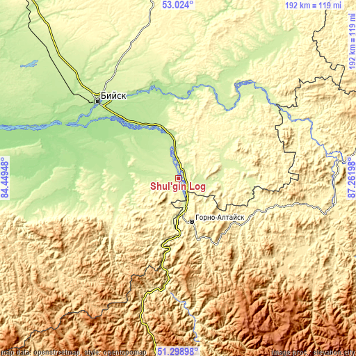
| \ | Map #1 | Topo.Map |
| Scale [m] | 225..303 m | × |
| Scale [ft] | 738..994 ft | × |
| Average | 242.2 m = 795 ft | × |
| Width | 5.99 km = 3.7 mi | 191.8 km = 119.2 mi |
| Height | 5.99 km = 3.7 mi | 191.8 km = 119.2 mi |
| ↑Max Latitude | 52.196794° | 53.024° |
| Latitude at center | 52.16985° | 52.16985° |
| ↓Min Latitude | 52.142889° | 51.29898° |
| ← Min Longitude | 85.811785° | 84.44948° |
| Longitude center | 85.85573° | 85.85573° |
| →Max Longitude | 85.899675° | 87.26198° |
Nearby cities:
Cities around Shul’gin Log sort by population:
• Gorno-Altaysk elevation 285 m
23.7 km,  169°
169°
• Mayma 252 m
17.5 km, 167°
• Krasnogorskoye 255 m
27.2 km,  59°
59°
• Sovetskoye 207 m
32.7 km,  293°
293°
• Srostki 209 m
29.9 km,  339°
339°
• Aya 270 m
25.2 km,  188°
188°
• Bystryanka 222 m
13.1 km,  351°
351°
• Manzherok 282 m
38.2 km, 188°
• Ust’-Isha 244 m
7.7 km,  79°
79°
• Berëzovka 214 m
20.2 km, 354°
• Krasnyy Yar 181 m
40.9 km,  300°
300°
• Souzga 285 m
31.4 km,  180°
180°
Multilingual:
 En español:
Shul’gin Log elevación 243 m.
 En France:
Shul’gin Log élévation 243 m.
 Auf Deutsch:
Shul’gin Log höhe über dem Meeresspiegel ist 243 m.
 На русском:
Шульгин Лог, Шульгин-Лог высота над уровнем моря 243 м
Sources and notes:
- [note 1] Map square and city borders are not equal. Map elevation data is calculated only from area inside that square.
- [src 1] Elevation data from geonames database provided with same terms of usage.
- [src 2] The elevation map of Shul’gin Log is generated using elevation data from NASA's 3 arcsec (90m) resolution SRTM data.
- [src 3] Base (background) map © OpenStreetMap contributors tiles are generated by Geofabrik and OpenTopoMap.
Copyright & License:
This Shul’gin Log Elevation Map is licensed under CC BY-SA. You may reuse any part from this page, if you give a proper credit by linking to this URL:
 More info on terms of use page.