Degtyarsk elevation
Degtyarsk (Sverdlovsk), Russia elevation is 350 meters and Degtyarsk elevation in feet is 1148 ft above sea level [src 1]. Degtyarsk is a populated place (feature code) with elevation that is 151 meters (495 ft) bigger than average city elevation in Russia.
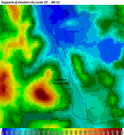
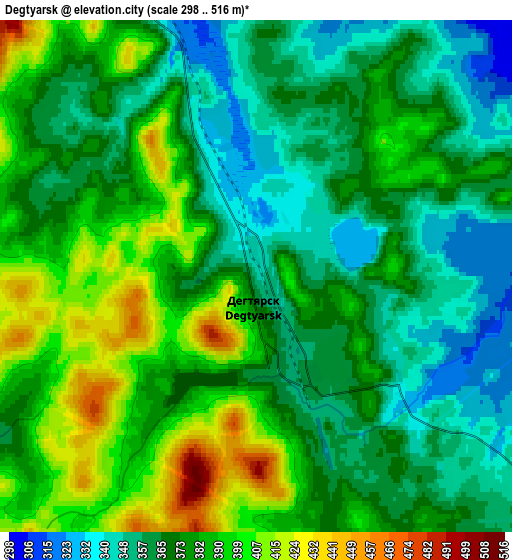
Below is the Elevation map of Degtyarsk, which displays elevation range with different colors. Scale of the first map is from 321 to 486 m (1053 to 1594 ft) with average elevation of 374.1 meters (=1227 ft) [note 1]
These maps also provides idea of topography and contour of this city, they are displayed at different zoom levels. More info about maps, scale and edge coordinates you can find below images.
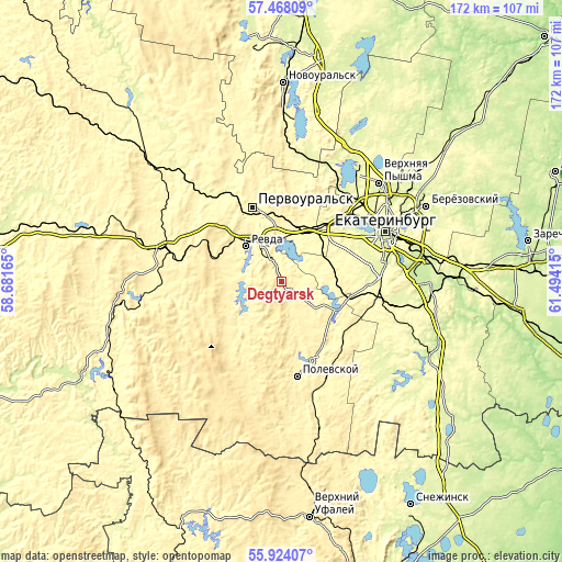
| \ | Map #1 | Map #2 | Topo.Map |
| Scale [m] | 321..486 m | 298..516 m | × |
| Scale [ft] | 1053..1594 ft | 978..1693 ft | × |
| Average | 374.1 m = 1227 ft | 375.4 m = 1232 ft | × |
| Width | 5.36 km = 3.3 mi | 10.73 km = 6.7 mi | 171.7 km = 106.7 mi |
| Height | 5.36 km = 3.3 mi | 10.73 km = 6.7 mi | 171.7 km = 106.7 mi |
| ↑Max Latitude | 56.728117° | 56.752218° | 57.46809° |
| Latitude at center | 56.704° | 56.704° | 56.704° |
| ↓Min Latitude | 56.679868° | 56.65572° | 55.92407° |
| ← Min Longitude | 60.043955° | 60.000009° | 58.68165° |
| Longitude center | 60.0879° | 60.0879° | 60.0879° |
| →Max Longitude | 60.131845° | 60.175791° | 61.49415° |
Nearby cities:
Cities around Degtyarsk sort by population:
• Pervoural’sk elevation 352 m
24 km,  338°
338°
• Polevskoy 358 m
29.7 km,  168°
168°
• Revda 311 m
14.4 km,  318°
318°
• Talitsa 332 m
20 km,  348°
348°
• Verkhniye Sergi 347 m
33.1 km,  258°
258°
• Gornyy Shchit 286 m
26.4 km,  93°
93°
• Shabrovskiy 321 m
31 km,  104°
104°
• Severka 274 m
22.5 km,  35°
35°
• Sovkhoznyy 270 m
28.9 km,  76°
76°
• Zyuzel’skiy 402 m
24.4 km, 173°
• Shirokaya Rechka 274 m
26.4 km,  66°
66°
• Shuvakish 270 m
33.6 km, 44°
Multilingual:
 En español:
Degtyarsk elevación 350 m.
 En France:
Degtyarsk élévation 350 m.
 Auf Deutsch:
Degtyarsk höhe über dem Meeresspiegel ist 350 m.

Sources and notes:
- [note 1] Map square and city borders are not equal. Map elevation data is calculated only from area inside that square.
- [src 1] Elevation data from geonames database provided with same terms of usage.
- [src 2] The elevation map of Degtyarsk is generated using elevation data from NASA's 3 arcsec (90m) resolution SRTM data.
- [src 3] Base (background) map © OpenStreetMap contributors tiles are generated by Geofabrik and OpenTopoMap.
Copyright & License:
This Degtyarsk Elevation Map is licensed under CC BY-SA. You may reuse any part from this page, if you give a proper credit by linking to this URL:
 More info on terms of use page.