Sovkhoznyy elevation
Sovkhoznyy (Sverdlovsk), Russia elevation is 270 meters and Sovkhoznyy elevation in feet is 886 ft above sea level [src 1]. Sovkhoznyy is a populated place (feature code) with elevation that is 71 meters (233 ft) bigger than average city elevation in Russia.
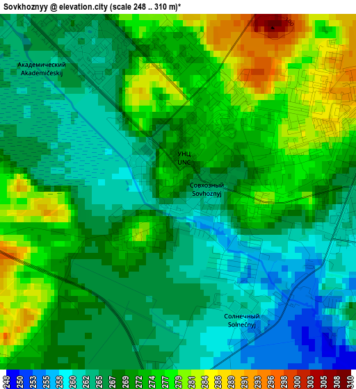
Below is the Elevation map of Sovkhoznyy, which displays elevation range with different colors. Scale of the first map is from 248 to 310 m (814 to 1017 ft) with average elevation of 269.7 meters (=885 ft) [note 1]
These maps also provides idea of topography and contour of this city, they are displayed at different zoom levels. More info about maps, scale and edge coordinates you can find below images.
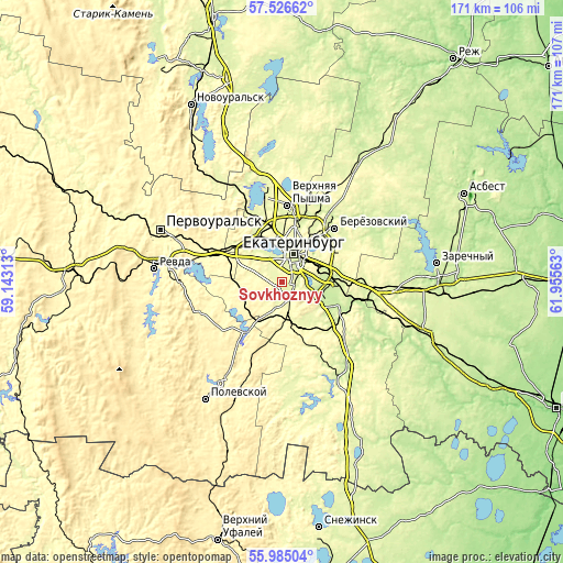
| \ | Map #1 | Topo.Map |
| Scale [m] | 248..310 m | × |
| Scale [ft] | 814..1017 ft | × |
| Average | 269.7 m = 885 ft | × |
| Width | 5.36 km = 3.3 mi | 171.4 km = 106.5 mi |
| Height | 5.36 km = 3.3 mi | 171.4 km = 106.5 mi |
| ↑Max Latitude | 56.787818° | 57.52662° |
| Latitude at center | 56.76374° | 56.76374° |
| ↓Min Latitude | 56.739646° | 55.98504° |
| ← Min Longitude | 60.505435° | 59.14313° |
| Longitude center | 60.54938° | 60.54938° |
| →Max Longitude | 60.593325° | 61.95563° |
Nearby cities:
Cities around Sovkhoznyy sort by population:
• Yekaterinburg elevation 255 m
10.5 km,  21°
21°
• Verkhnyaya Pyshma 276 m
23.1 km,  4°
4°
• Beryozovsky 257 m
22.2 km,  43°
43°
• Sredneuralsk 277 m
25.6 km,  348°
348°
• Aramil 215 m
19 km,  112°
112°
• Istok 245 m
14.3 km,  77°
77°
• Gornyy Shchit 286 m
8.6 km,  192°
192°
• Shabrovskiy 321 m
14.3 km,  172°
172°
• Severka 274 m
19.1 km,  307°
307°
• Iset’ 266 m
26.1 km,  335°
335°
• Shirokaya Rechka 274 m
5.5 km, 314°
• Shuvakish 270 m
17.8 km, 345°
Multilingual:
 En español:
Sovkhoznyy elevación 270 m.
 En France:
Sovkhoznyy élévation 270 m.
 Auf Deutsch:
Sovkhoznyy höhe über dem Meeresspiegel ist 270 m.

Sources and notes:
- [note 1] Map square and city borders are not equal. Map elevation data is calculated only from area inside that square.
- [src 1] Elevation data from geonames database provided with same terms of usage.
- [src 2] The elevation map of Sovkhoznyy is generated using elevation data from NASA's 3 arcsec (90m) resolution SRTM data.
- [src 3] Base (background) map © OpenStreetMap contributors tiles are generated by Geofabrik and OpenTopoMap.
Copyright & License:
This Sovkhoznyy Elevation Map is licensed under CC BY-SA. You may reuse any part from this page, if you give a proper credit by linking to this URL:
 More info on terms of use page.