Sredneuralsk elevation
Sredneuralsk (Sverdlovsk), Russia elevation is 277 meters and Sredneuralsk elevation in feet is 909 ft above sea level [src 1]. Sredneuralsk is a populated place (feature code) with elevation that is 78 meters (256 ft) bigger than average city elevation in Russia.
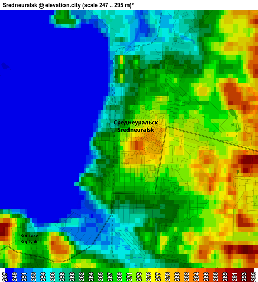
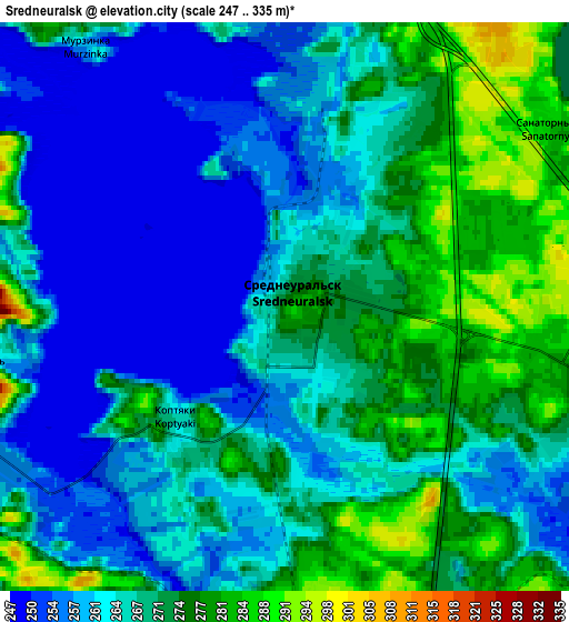
Below is the Elevation map of Sredneuralsk, which displays elevation range with different colors. Scale of the first map is from 247 to 295 m (810 to 968 ft) with average elevation of 262.4 meters (=861 ft) [note 1]
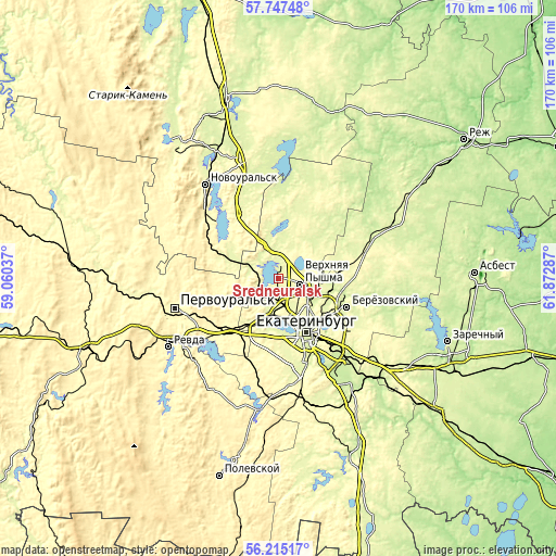
These maps also provides idea of topography and contour of this city, they are displayed at different zoom levels. More info about maps, scale and edge coordinates you can find below images.
| \ | Map #1 | Map #2 | Topo.Map |
| Scale [m] | 247..295 m | 247..335 m | × |
| Scale [ft] | 810..968 ft | 810..1099 ft | × |
| Average | 262.4 m = 861 ft | 266.4 m = 874 ft | × |
| Width | 5.32 km = 3.3 mi | 10.65 km = 6.6 mi | 170.4 km = 105.9 mi |
| Height | 5.32 km = 3.3 mi | 10.65 km = 6.6 mi | 170.4 km = 105.9 mi |
| ↑Max Latitude | 57.013144° | 57.037062° | 57.74748° |
| Latitude at center | 56.98921° | 56.98921° | 56.98921° |
| ↓Min Latitude | 56.965261° | 56.941297° | 56.21517° |
| ← Min Longitude | 60.422675° | 60.378729° | 59.06037° |
| Longitude center | 60.46662° | 60.46662° | 60.46662° |
| →Max Longitude | 60.510565° | 60.554511° | 61.87287° |
Nearby cities:
Cities around Sredneuralsk sort by population:
• Yekaterinburg elevation 255 m
17.6 km,  149°
149°
• Verkhnyaya Pyshma 276 m
7.3 km,  106°
106°
• Beryozovsky 257 m
22.2 km, 113°
• Monetnyy 275 m
25.8 km,  75°
75°
• Severka 274 m
16.7 km,  216°
216°
• Iset’ 266 m
5.9 km,  257°
257°
• Sovkhoznyy 270 m
25.6 km,  168°
168°
• Kalinovo 290 m
25 km,  309°
309°
• Kedrovoye 270 m
19.7 km,  18°
18°
• Staropyshminsk 225 m
27 km,  101°
101°
• Shirokaya Rechka 274 m
21.2 km,  176°
176°
• Shuvakish 270 m
7.9 km, 175°
Multilingual:
 En español:
Sredneuralsk elevación 277 m.
 En France:
Sredneouralsk élévation 277 m.
 Auf Deutsch:
Sredneuralsk höhe über dem Meeresspiegel ist 277 m.

Sources and notes:
- [note 1] Map square and city borders are not equal. Map elevation data is calculated only from area inside that square.
- [src 1] Elevation data from geonames database provided with same terms of usage.
- [src 2] The elevation map of Sredneuralsk is generated using elevation data from NASA's 3 arcsec (90m) resolution SRTM data.
- [src 3] Base (background) map © OpenStreetMap contributors tiles are generated by Geofabrik and OpenTopoMap.
Copyright & License:
This Sredneuralsk Elevation Map is licensed under CC BY-SA. You may reuse any part from this page, if you give a proper credit by linking to this URL:
 More info on terms of use page.