Kalmanka elevation
Kalmanka (Altai Krai), Russia elevation is 156 meters and Kalmanka elevation in feet is 512 ft above sea level [src 1]. Kalmanka is a populated place (feature code) with elevation that is 43 meters (141 ft) smaller than average city elevation in Russia.
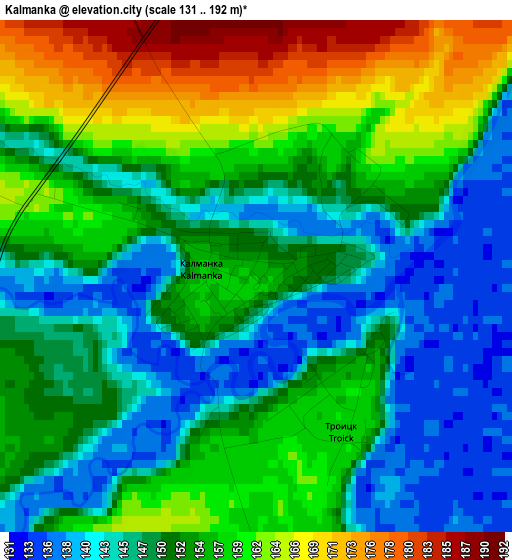
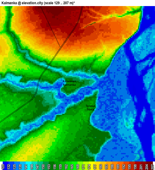
Below is the Elevation map of Kalmanka, which displays elevation range with different colors. Scale of the first map is from 131 to 192 m (430 to 630 ft) with average elevation of 152.6 meters (=501 ft) [note 1]
These maps also provides idea of topography and contour of this city, they are displayed at different zoom levels. More info about maps, scale and edge coordinates you can find below images.
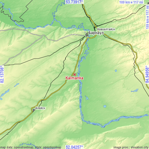
| \ | Map #1 | Map #2 | Topo.Map |
| Scale [m] | 131..192 m | 129..207 m | × |
| Scale [ft] | 430..630 ft | 423..679 ft | × |
| Average | 152.6 m = 501 ft | 158 m = 518 ft | × |
| Width | 5.89 km = 3.7 mi | 11.79 km = 7.3 mi | 188.6 km = 117.2 mi |
| Height | 5.9 km = 3.7 mi | 11.79 km = 7.3 mi | 188.6 km = 117.2 mi |
| ↑Max Latitude | 52.925671° | 52.952155° | 53.73917° |
| Latitude at center | 52.89917° | 52.89917° | 52.89917° |
| ↓Min Latitude | 52.872653° | 52.84612° | 52.04257° |
| ← Min Longitude | 83.499385° | 83.455439° | 82.13708° |
| Longitude center | 83.54333° | 83.54333° | 83.54333° |
| →Max Longitude | 83.587275° | 83.631221° | 84.94958° |
Nearby cities:
Cities around Kalmanka sort by population:
• Yuzhnyy elevation 213 m
40.7 km,  14°
14°
• Novosilikatnyy 201 m
46 km, 6°
• Topchikha 200 m
29.9 km,  252°
252°
• Nagornyy 151 m
11.5 km,  177°
177°
• Vlasikha 176 m
44.3 km,  2°
2°
• Lebyazh’ye 214 m
39 km, 10°
• Cheremnoye 196 m
37.3 km,  323°
323°
• Novyye Zori 197 m
39.6 km,  348°
348°
• Zaton 132 m
47.3 km,  21°
21°
• Bobrovka 135 m
38.7 km,  35°
35°
• Shakhi 251 m
50.1 km, 346°
• Stukovo 190 m
37.5 km,  338°
338°
Multilingual:
 En español:
Kalmanka elevación 156 m.
 En France:
Kalmanka élévation 156 m.
 Auf Deutsch:
Kalmanka höhe über dem Meeresspiegel ist 156 m.

Sources and notes:
- [note 1] Map square and city borders are not equal. Map elevation data is calculated only from area inside that square.
- [src 1] Elevation data from geonames database provided with same terms of usage.
- [src 2] The elevation map of Kalmanka is generated using elevation data from NASA's 3 arcsec (90m) resolution SRTM data.
- [src 3] Base (background) map © OpenStreetMap contributors tiles are generated by Geofabrik and OpenTopoMap.
Copyright & License:
This Kalmanka Elevation Map is licensed under CC BY-SA. You may reuse any part from this page, if you give a proper credit by linking to this URL:
 More info on terms of use page.