Kataysk elevation
Kataysk (Kurgan Oblast), Russia elevation is 109 meters and Kataysk elevation in feet is 358 ft above sea level [src 1]. Kataysk is a populated place (feature code) with elevation that is 90 meters (295 ft) smaller than average city elevation in Russia.
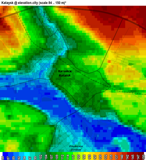
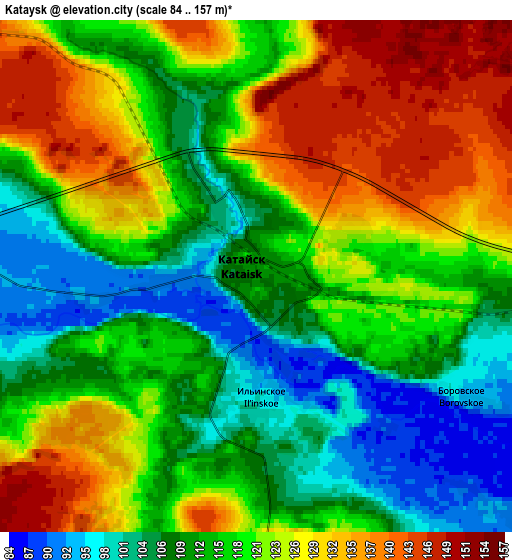
Below is the Elevation map of Kataysk, which displays elevation range with different colors. Scale of the first map is from 84 to 150 m (276 to 492 ft) with average elevation of 111.4 meters (=365 ft) [note 1]
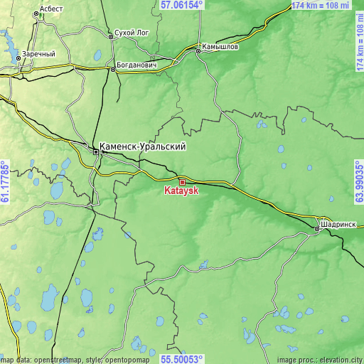
These maps also provides idea of topography and contour of this city, they are displayed at different zoom levels. More info about maps, scale and edge coordinates you can find below images.
| \ | Map #1 | Map #2 | Topo.Map |
| Scale [m] | 84..150 m | 84..157 m | × |
| Scale [ft] | 276..492 ft | 276..515 ft | × |
| Average | 111.4 m = 365 ft | 118.3 m = 388 ft | × |
| Width | 5.42 km = 3.4 mi | 10.85 km = 6.7 mi | 173.6 km = 107.9 mi |
| Height | 5.42 km = 3.4 mi | 10.85 km = 6.7 mi | 173.5 km = 107.8 mi |
| ↑Max Latitude | 56.313382° | 56.337749° | 57.06154° |
| Latitude at center | 56.289° | 56.289° | 56.289° |
| ↓Min Latitude | 56.264602° | 56.240189° | 55.50053° |
| ← Min Longitude | 62.540155° | 62.496209° | 61.17785° |
| Longitude center | 62.5841° | 62.5841° | 62.5841° |
| →Max Longitude | 62.628045° | 62.671991° | 63.99035° |
Nearby cities:
Cities around Kataysk sort by population:
• Kamensk-Ural’skiy elevation 173 m
42.6 km,  289°
289°
• Shadrinsk 80 m
68.8 km,  109°
109°
• Bogdanovich 162 m
63.7 km,  329°
329°
• Kamyshlov 92 m
62.1 km,  7°
7°
• Dalmatovo 105 m
22 km,  98°
98°
• Yelanskiy 114 m
61.7 km,  355°
355°
• Martyush 167 m
45 km, 285°
• Pokrovskoye 187 m
63.3 km, 288°
• Ust’-Bagaryak 130 m
48.8 km,  249°
249°
• Obukhovskoye 90 m
60.7 km,  1°
1°
• Gryaznovskoye 199 m
76.9 km,  315°
315°
• Baraba 210 m
71.7 km, 315°
Multilingual:
 En español:
Kataysk elevación 109 m.
 En France:
Kataysk élévation 109 m.


Sources and notes:
- [note 1] Map square and city borders are not equal. Map elevation data is calculated only from area inside that square.
- [src 1] Elevation data from geonames database provided with same terms of usage.
- [src 2] The elevation map of Kataysk is generated using elevation data from NASA's 3 arcsec (90m) resolution SRTM data.
- [src 3] Base (background) map © OpenStreetMap contributors tiles are generated by Geofabrik and OpenTopoMap.
Copyright & License:
This Kataysk Elevation Map is licensed under CC BY-SA. You may reuse any part from this page, if you give a proper credit by linking to this URL:
 More info on terms of use page.