Shadrinsk elevation
Shadrinsk (Kurgan Oblast), Russia elevation is 80 meters and Shadrinsk elevation in feet is 262 ft above sea level [src 1]. Shadrinsk is a populated place (feature code) with elevation that is 119 meters (390 ft) smaller than average city elevation in Russia.
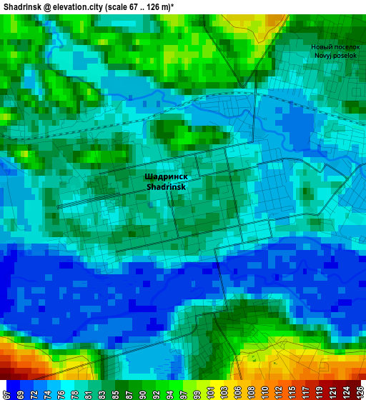
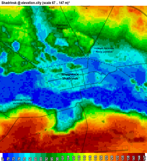
Below is the Elevation map of Shadrinsk, which displays elevation range with different colors. Scale of the first map is from 67 to 126 m (220 to 413 ft) with average elevation of 81.6 meters (=268 ft) [note 1]
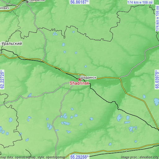
These maps also provides idea of topography and contour of this city, they are displayed at different zoom levels. More info about maps, scale and edge coordinates you can find below images.
| \ | Map #1 | Map #2 | Topo.Map |
| Scale [m] | 67..126 m | 67..147 m | × |
| Scale [ft] | 220..413 ft | 220..482 ft | × |
| Average | 81.6 m = 268 ft | 99.6 m = 327 ft | × |
| Width | 5.45 km = 3.4 mi | 10.91 km = 6.8 mi | 174.5 km = 108.4 mi |
| Height | 5.45 km = 3.4 mi | 10.91 km = 6.8 mi | 174.5 km = 108.4 mi |
| ↑Max Latitude | 56.109712° | 56.134208° | 56.86187° |
| Latitude at center | 56.0852° | 56.0852° | 56.0852° |
| ↓Min Latitude | 56.060672° | 56.036129° | 55.29255° |
| ← Min Longitude | 63.589555° | 63.545609° | 62.22725° |
| Longitude center | 63.6335° | 63.6335° | 63.6335° |
| →Max Longitude | 63.677445° | 63.721391° | 65.03975° |
Nearby cities:
Cities around Shadrinsk sort by population:
• Kamyshlov elevation 92 m
101.5 km,  326°
326°
• Shumikha 174 m
97.8 km,  192°
192°
• Kataysk 109 m
68.8 km,  289°
289°
• Dalmatovo 105 m
47.3 km, 294°
• Pyshma 88 m
99.2 km,  346°
346°
• Mishkino 151 m
84.9 km,  167°
167°
• Yurgamysh 153 m
94.5 km,  146°
146°
• Shatrovo 114 m
78.3 km,  51°
51°
• Ikovka 135 m
97.1 km,  123°
123°
• Krasnyy Oktyabr’ 126 m
87.7 km, 122°
• Butka 115 m
71 km,  7°
7°
• Yertarskiy 82 m
88.4 km,  27°
27°
Multilingual:
 En español:
Shadrinsk elevación 80 m.
 En France:
Chadrinsk élévation 80 m.
 Auf Deutsch:
Shadrinsk höhe über dem Meeresspiegel ist 80 m.

Sources and notes:
- [note 1] Map square and city borders are not equal. Map elevation data is calculated only from area inside that square.
- [src 1] Elevation data from geonames database provided with same terms of usage.
- [src 2] The elevation map of Shadrinsk is generated using elevation data from NASA's 3 arcsec (90m) resolution SRTM data.
- [src 3] Base (background) map © OpenStreetMap contributors tiles are generated by Geofabrik and OpenTopoMap.
Copyright & License:
This Shadrinsk Elevation Map is licensed under CC BY-SA. You may reuse any part from this page, if you give a proper credit by linking to this URL:
 More info on terms of use page.