Kochki elevation
Kochki (Novosibirsk Oblast), Russia elevation is 156 meters and Kochki elevation in feet is 512 ft above sea level [src 1]. Kochki is a populated place (feature code) with elevation that is 43 meters (141 ft) smaller than average city elevation in Russia.
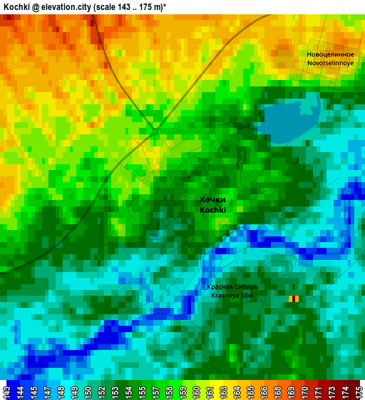
Below is the Elevation map of Kochki, which displays elevation range with different colors. Scale of the first map is from 143 to 175 m (469 to 574 ft) with average elevation of 155.3 meters (=510 ft) [note 1]
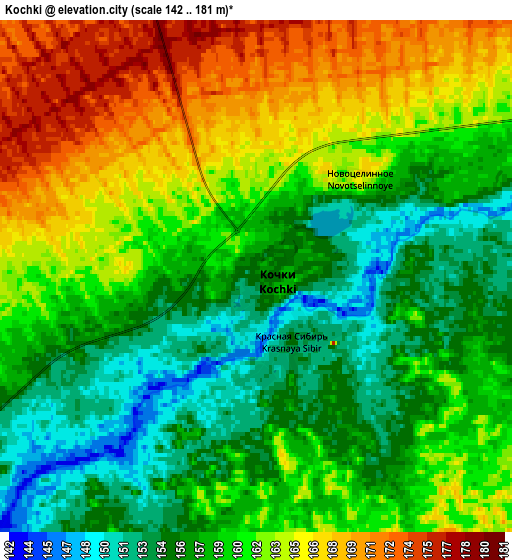
These maps also provides idea of topography and contour of this city, they are displayed at different zoom levels. More info about maps, scale and edge coordinates you can find below images.
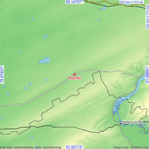
| \ | Map #1 | Map #2 | Topo.Map |
| Scale [m] | 143..175 m | 142..181 m | × |
| Scale [ft] | 469..574 ft | 466..594 ft | × |
| Average | 155.3 m = 510 ft | 159.6 m = 524 ft | × |
| Width | 5.7 km = 3.5 mi | 11.4 km = 7.1 mi | 182.3 km = 113.3 mi |
| Height | 5.7 km = 3.5 mi | 11.4 km = 7.1 mi | 182.3 km = 113.3 mi |
| ↑Max Latitude | 54.361444° | 54.387041° | 55.14757° |
| Latitude at center | 54.33583° | 54.33583° | 54.33583° |
| ↓Min Latitude | 54.3102° | 54.284555° | 53.50774° |
| ← Min Longitude | 80.436615° | 80.392669° | 79.07431° |
| Longitude center | 80.48056° | 80.48056° | 80.48056° |
| →Max Longitude | 80.524505° | 80.568451° | 81.88681° |
Nearby cities:
Cities around Kochki sort by population:
• Kamen’-na-Obi elevation 125 m
82.9 km,  137°
137°
• Chulym 140 m
90.3 km,  19°
19°
• Kargat 132 m
96.4 km,  352°
352°
• Krasnozërskoye 140 m
90 km,  244°
244°
• Ordynskoye 127 m
92 km,  87°
87°
• Khabary 138 m
100.3 km,  218°
218°
• Ubinskoye 145 m
119.5 km,  334°
334°
• Pankrushikha 164 m
56.8 km,  189°
189°
• Bayevo 121 m
120 km,  170°
170°
• Krutikha 125 m
63.2 km,  131°
131°
• Polovinnoye 176 m
103.3 km,  231°
231°
• Verkh-Suetka 138 m
118.2 km, 193°
Multilingual:
 En español:
Kochki elevación 156 m.
 En France:
Kochki élévation 156 m.


Sources and notes:
- [note 1] Map square and city borders are not equal. Map elevation data is calculated only from area inside that square.
- [src 1] Elevation data from geonames database provided with same terms of usage.
- [src 2] The elevation map of Kochki is generated using elevation data from NASA's 3 arcsec (90m) resolution SRTM data.
- [src 3] Base (background) map © OpenStreetMap contributors tiles are generated by Geofabrik and OpenTopoMap.
Copyright & License:
This Kochki Elevation Map is licensed under CC BY-SA. You may reuse any part from this page, if you give a proper credit by linking to this URL:
 More info on terms of use page.