Malysheva elevation
Malysheva (Sverdlovsk), Russia elevation is 239 meters and Malysheva elevation in feet is 784 ft above sea level [src 1]. Malysheva is a populated place (feature code) with elevation that is 40 meters (131 ft) bigger than average city elevation in Russia.
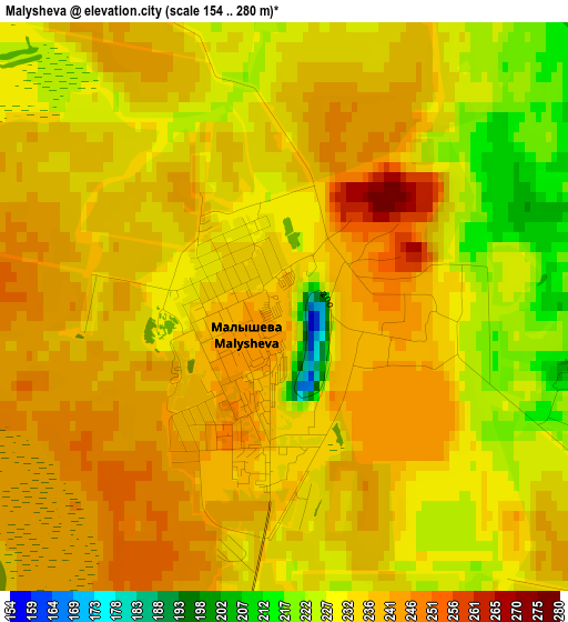
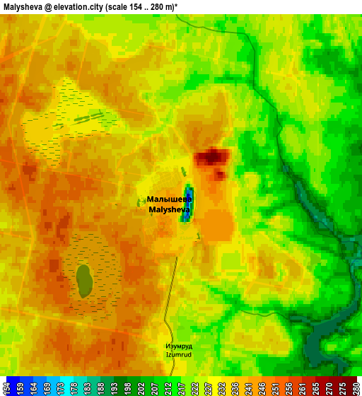
Below is the Elevation map of Malysheva, which displays elevation range with different colors. Scale of the first map is from 154 to 280 m (505 to 919 ft) with average elevation of 235.3 meters (=772 ft) [note 1]
These maps also provides idea of topography and contour of this city, they are displayed at different zoom levels. More info about maps, scale and edge coordinates you can find below images.
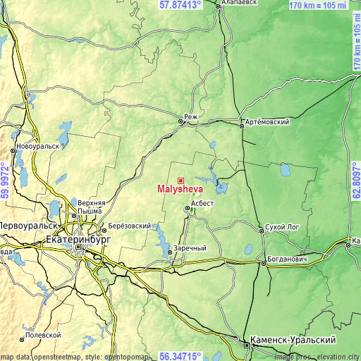
| \ | Map #1 | Map #2 | Topo.Map |
| Scale [m] | 154..280 m | 154..280 m | × |
| Scale [ft] | 505..919 ft | 505..919 ft | × |
| Average | 235.3 m = 772 ft | 229.8 m = 754 ft | × |
| Width | 5.31 km = 3.3 mi | 10.61 km = 6.6 mi | 169.8 km = 105.5 mi |
| Height | 5.31 km = 3.3 mi | 10.61 km = 6.6 mi | 169.8 km = 105.5 mi |
| ↑Max Latitude | 57.14236° | 57.166195° | 57.87413° |
| Latitude at center | 57.11851° | 57.11851° | 57.11851° |
| ↓Min Latitude | 57.094644° | 57.070763° | 56.34715° |
| ← Min Longitude | 61.359505° | 61.315559° | 59.9972° |
| Longitude center | 61.40345° | 61.40345° | 61.40345° |
| →Max Longitude | 61.447395° | 61.491341° | 62.8097° |
Nearby cities:
Cities around Malysheva sort by population:
• Asbest elevation 219 m
12.5 km,  164°
164°
• Rezh 164 m
28 km,  0°
0°
• Artëmovskiy 181 m
38.4 km,  46°
46°
• Zarechnyy 245 m
34.5 km,  187°
187°
• Reftinskiy 185 m
16.8 km,  100°
100°
• Bulanash 139 m
39.9 km,  63°
63°
• Beloyarskiy 196 m
40 km,  179°
179°
• Monetnyy 275 m
32.6 km,  255°
255°
• Losinyy 246 m
20.4 km,  276°
276°
• Klyuchevsk 232 m
27.9 km,  270°
270°
• Staropyshminsk 225 m
36.3 km,  236°
236°
• Izumrud 226 m
4.4 km, 183°
Multilingual:
 En español:
Malysheva elevación 239 m.
 En France:
Malysheva élévation 239 m.
 Auf Deutsch:
Malysheva höhe über dem Meeresspiegel ist 239 m.

Sources and notes:
- [note 1] Map square and city borders are not equal. Map elevation data is calculated only from area inside that square.
- [src 1] Elevation data from geonames database provided with same terms of usage.
- [src 2] The elevation map of Malysheva is generated using elevation data from NASA's 3 arcsec (90m) resolution SRTM data.
- [src 3] Base (background) map © OpenStreetMap contributors tiles are generated by Geofabrik and OpenTopoMap.
Copyright & License:
This Malysheva Elevation Map is licensed under CC BY-SA. You may reuse any part from this page, if you give a proper credit by linking to this URL:
 More info on terms of use page.