Zarechnyy elevation
Zarechnyy (Sverdlovsk), Russia elevation is 245 meters and Zarechnyy elevation in feet is 804 ft above sea level [src 1]. Zarechnyy is a populated place (feature code) with elevation that is 46 meters (151 ft) bigger than average city elevation in Russia.
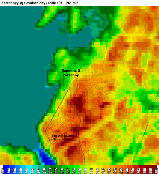
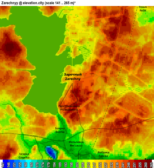
Below is the Elevation map of Zarechnyy, which displays elevation range with different colors. Scale of the first map is from 191 to 261 m (627 to 856 ft) with average elevation of 225.7 meters (=740 ft) [note 1]
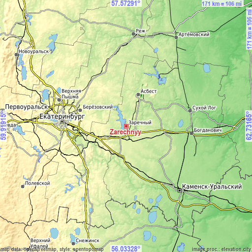
These maps also provides idea of topography and contour of this city, they are displayed at different zoom levels. More info about maps, scale and edge coordinates you can find below images.
| \ | Map #1 | Map #2 | Topo.Map |
| Scale [m] | 191..261 m | 141..265 m | × |
| Scale [ft] | 627..856 ft | 463..869 ft | × |
| Average | 225.7 m = 740 ft | 223.5 m = 733 ft | × |
| Width | 5.35 km = 3.3 mi | 10.7 km = 6.6 mi | 171.2 km = 106.4 mi |
| Height | 5.35 km = 3.3 mi | 10.7 km = 6.6 mi | 171.2 km = 106.4 mi |
| ↑Max Latitude | 56.835048° | 56.859081° | 57.57291° |
| Latitude at center | 56.811° | 56.811° | 56.811° |
| ↓Min Latitude | 56.786937° | 56.762858° | 56.03328° |
| ← Min Longitude | 61.281455° | 61.237509° | 59.91915° |
| Longitude center | 61.3254° | 61.3254° | 61.3254° |
| →Max Longitude | 61.369345° | 61.413291° | 62.73165° |
Nearby cities:
Cities around Zarechnyy sort by population:
• Asbest elevation 219 m
23.5 km,  19°
19°
• Aramil 215 m
32.3 km,  247°
247°
• Beloyarskiy 196 m
8 km,  137°
137°
• Istok 245 m
33.3 km,  266°
266°
• Bobrovskiy 211 m
26 km,  233°
233°
• Dvurechensk 198 m
27.5 km,  210°
210°
• Verkhneye Dubrovo 274 m
18.2 km, 249°
• Sovkhoznyy 227 m
28.6 km,  167°
167°
• Staropyshminsk 225 m
29.3 km,  298°
298°
• Gryaznovskoye 199 m
23.3 km,  97°
97°
• Izumrud 226 m
30.1 km,  8°
8°
• Baraba 210 m
27.7 km, 104°
Multilingual:
 En español:
Zarechnyy elevación 245 m.
 En France:
Zarechnyy élévation 245 m.
 Auf Deutsch:
Zarechnyy höhe über dem Meeresspiegel ist 245 m.

Sources and notes:
- [note 1] Map square and city borders are not equal. Map elevation data is calculated only from area inside that square.
- [src 1] Elevation data from geonames database provided with same terms of usage.
- [src 2] The elevation map of Zarechnyy is generated using elevation data from NASA's 3 arcsec (90m) resolution SRTM data.
- [src 3] Base (background) map © OpenStreetMap contributors tiles are generated by Geofabrik and OpenTopoMap.
Copyright & License:
This Zarechnyy Elevation Map is licensed under CC BY-SA. You may reuse any part from this page, if you give a proper credit by linking to this URL:
 More info on terms of use page.