Nizhnyaya Tavda elevation
Nizhnyaya Tavda (Tyumen’ Oblast), Russia elevation is 57 meters and Nizhnyaya Tavda elevation in feet is 187 ft above sea level [src 1]. Nizhnyaya Tavda is a populated place (feature code) with elevation that is 142 meters (466 ft) smaller than average city elevation in Russia.
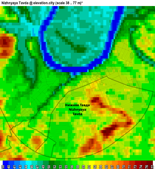
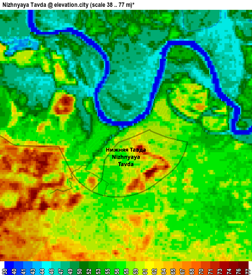
Below is the Elevation map of Nizhnyaya Tavda, which displays elevation range with different colors. Scale of the first map is from 38 to 77 m (125 to 253 ft) with average elevation of 55 meters (=180 ft) [note 1]
These maps also provides idea of topography and contour of this city, they are displayed at different zoom levels. More info about maps, scale and edge coordinates you can find below images.
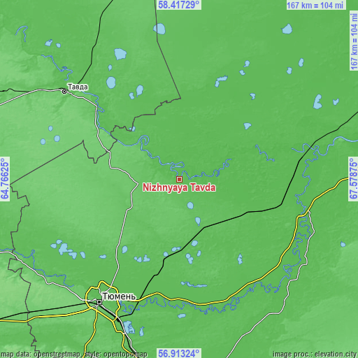
| \ | Map #1 | Map #2 | Topo.Map |
| Scale [m] | 38..77 m | 38..77 m | × |
| Scale [ft] | 125..253 ft | 125..253 ft | × |
| Average | 55 m = 180 ft | 55 m = 180 ft | × |
| Width | 5.23 km = 3.2 mi | 10.45 km = 6.5 mi | 167.2 km = 103.9 mi |
| Height | 5.23 km = 3.2 mi | 10.45 km = 6.5 mi | 167.2 km = 103.9 mi |
| ↑Max Latitude | 57.696552° | 57.720029° | 58.41729° |
| Latitude at center | 57.67306° | 57.67306° | 57.67306° |
| ↓Min Latitude | 57.649553° | 57.62603° | 56.91324° |
| ← Min Longitude | 66.128555° | 66.084609° | 64.76625° |
| Longitude center | 66.1725° | 66.1725° | 66.1725° |
| →Max Longitude | 66.216445° | 66.260391° | 67.57875° |
Nearby cities:
Cities around Nizhnyaya Tavda sort by population:
• Tyumen elevation 81 m
69.6 km,  213°
213°
• Tavda 83 m
67.2 km,  307°
307°
• Borovskiy 56 m
75.3 km,  201°
201°
• Vinzili 66 m
82.9 km, 196°
• Bogandinskiy 67 m
88.3 km,  190°
190°
• Yarkovo 51 m
61 km,  119°
119°
• Melioratorov 58 m
61.5 km, 213°
• Antipino 67 m
67.7 km, 201°
• Moskovskiy 101 m
77 km,  215°
215°
• Azanka 82 m
91.4 km,  296°
296°
• Chervishevo 63 m
92.4 km, 208°
• Onokhino 62 m
91.5 km, 204°
Multilingual:
 En español:
Nizhnyaya Tavda elevación 57 m.
 En France:
Nizhnyaya Tavda élévation 57 m.
 Auf Deutsch:
Nizhnyaya Tavda höhe über dem Meeresspiegel ist 57 m.

Sources and notes:
- [note 1] Map square and city borders are not equal. Map elevation data is calculated only from area inside that square.
- [src 1] Elevation data from geonames database provided with same terms of usage.
- [src 2] The elevation map of Nizhnyaya Tavda is generated using elevation data from NASA's 3 arcsec (90m) resolution SRTM data.
- [src 3] Base (background) map © OpenStreetMap contributors tiles are generated by Geofabrik and OpenTopoMap.
Copyright & License:
This Nizhnyaya Tavda Elevation Map is licensed under CC BY-SA. You may reuse any part from this page, if you give a proper credit by linking to this URL:
 More info on terms of use page.