Tavda elevation
Tavda (Sverdlovsk), Russia elevation is 83 meters and Tavda elevation in feet is 272 ft above sea level [src 1]. Tavda is a populated place (feature code) with elevation that is 116 meters (381 ft) smaller than average city elevation in Russia.
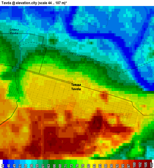
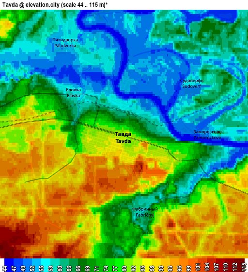
Below is the Elevation map of Tavda, which displays elevation range with different colors. Scale of the first map is from 44 to 107 m (144 to 351 ft) with average elevation of 72.3 meters (=237 ft) [note 1]
These maps also provides idea of topography and contour of this city, they are displayed at different zoom levels. More info about maps, scale and edge coordinates you can find below images.
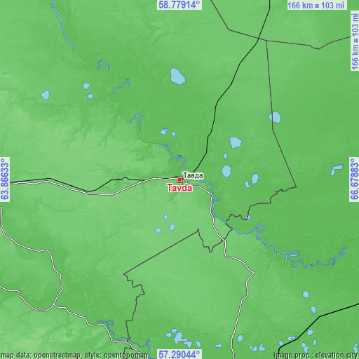
| \ | Map #1 | Map #2 | Topo.Map |
| Scale [m] | 44..107 m | 44..115 m | × |
| Scale [ft] | 144..351 ft | 144..377 ft | × |
| Average | 72.3 m = 237 ft | 72.6 m = 238 ft | × |
| Width | 5.17 km = 3.2 mi | 10.35 km = 6.4 mi | 165.5 km = 102.8 mi |
| Height | 5.17 km = 3.2 mi | 10.34 km = 6.4 mi | 165.5 km = 102.8 mi |
| ↑Max Latitude | 58.065792° | 58.089029° | 58.77914° |
| Latitude at center | 58.04254° | 58.04254° | 58.04254° |
| ↓Min Latitude | 58.019273° | 57.99599° | 57.29044° |
| ← Min Longitude | 65.228635° | 65.184689° | 63.86633° |
| Longitude center | 65.27258° | 65.27258° | 65.27258° |
| →Max Longitude | 65.316525° | 65.360471° | 66.67883° |
Nearby cities:
Cities around Tavda sort by population:
• Tyumen elevation 81 m
100.2 km,  171°
171°
• Turinsk 100 m
92.8 km,  270°
270°
• Borovskiy 56 m
114.5 km, 166°
• Nizhnyaya Tavda 57 m
67.2 km,  127°
127°
• Baykalovo 88 m
114.5 km,  231°
231°
• Turinskaya Sloboda 64 m
70.2 km, 228°
• Melioratorov 58 m
94.6 km, 167°
• Antipino 67 m
108 km,  164°
164°
• Moskovskiy 101 m
104 km,  175°
175°
• Azanka 82 m
28.4 km, 269°
• Kuminskiy 63 m
102.5 km,  47°
47°
• Tabory 64 m
67.8 km,  321°
321°
Multilingual:
 En español:
Tavdá elevación 83 m.
 En France:
Tavda élévation 83 m.


Sources and notes:
- [note 1] Map square and city borders are not equal. Map elevation data is calculated only from area inside that square.
- [src 1] Elevation data from geonames database provided with same terms of usage.
- [src 2] The elevation map of Tavda is generated using elevation data from NASA's 3 arcsec (90m) resolution SRTM data.
- [src 3] Base (background) map © OpenStreetMap contributors tiles are generated by Geofabrik and OpenTopoMap.
Copyright & License:
This Tavda Elevation Map is licensed under CC BY-SA. You may reuse any part from this page, if you give a proper credit by linking to this URL:
 More info on terms of use page.