Pirovskoye elevation
Pirovskoye (Krasnoyarskiy), Russia elevation is 181 meters and Pirovskoye elevation in feet is 594 ft above sea level [src 1]. Pirovskoye is a populated place (feature code) with elevation that is 18 meters (59 ft) smaller than average city elevation in Russia.
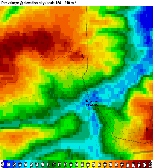
Below is the Elevation map of Pirovskoye, which displays elevation range with different colors. Scale of the first map is from 154 to 210 m (505 to 689 ft) with average elevation of 182.6 meters (=599 ft) [note 1]
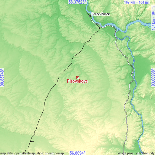
These maps also provides idea of topography and contour of this city, they are displayed at different zoom levels. More info about maps, scale and edge coordinates you can find below images.
| \ | Map #1 | Topo.Map |
| Scale [m] | 154..210 m | × |
| Scale [ft] | 505..689 ft | × |
| Average | 182.6 m = 599 ft | × |
| Width | 5.23 km = 3.2 mi | 167.4 km = 104 mi |
| Height | 5.23 km = 3.2 mi | 167.4 km = 104 mi |
| ↑Max Latitude | 57.65364° | 58.37523° |
| Latitude at center | 57.63012° | 57.63012° |
| ↓Min Latitude | 57.606585° | 56.8694° |
| ← Min Longitude | 92.219785° | 90.85748° |
| Longitude center | 92.26373° | 92.26373° |
| →Max Longitude | 92.307675° | 93.66998° |
Nearby cities:
Cities around Pirovskoye sort by population:
• Lesosibirsk elevation 82 m
68.6 km,  10°
10°
• Yeniseysk 74 m
91.2 km,  356°
356°
• Yemel’yanovo 211 m
164.5 km,  171°
171°
• Taseyevo 143 m
164.1 km,  106°
106°
• Motygino 123 m
156.2 km,  66°
66°
• Strelka 84 m
67.1 km,  42°
42°
• Kedrovyy 290 m
156.2 km,  196°
196°
• Sukhobuzimskoye 159 m
139.7 km,  154°
154°
• Novobirilyussy 177 m
121.3 km,  231°
231°
• Kazachinskoye 90 m
61 km,  82°
82°
• Rassvet 206 m
84.7 km,  214°
214°
• Predivinsk 141 m
94.5 km,  131°
131°
Multilingual:
 En español:
Pirovskoye elevación 181 m.
 En France:
Pirovskoye élévation 181 m.
 Auf Deutsch:
Pirovskoye höhe über dem Meeresspiegel ist 181 m.

Sources and notes:
- [note 1] Map square and city borders are not equal. Map elevation data is calculated only from area inside that square.
- [src 1] Elevation data from geonames database provided with same terms of usage.
- [src 2] The elevation map of Pirovskoye is generated using elevation data from NASA's 3 arcsec (90m) resolution SRTM data.
- [src 3] Base (background) map © OpenStreetMap contributors tiles are generated by Geofabrik and OpenTopoMap.
Copyright & License:
This Pirovskoye Elevation Map is licensed under CC BY-SA. You may reuse any part from this page, if you give a proper credit by linking to this URL:
 More info on terms of use page.