Kedrovyy elevation
Kedrovyy (Krasnoyarskiy), Russia elevation is 290 meters and Kedrovyy elevation in feet is 951 ft above sea level [src 1]. Kedrovyy is a populated place (feature code) with elevation that is 91 meters (299 ft) bigger than average city elevation in Russia.
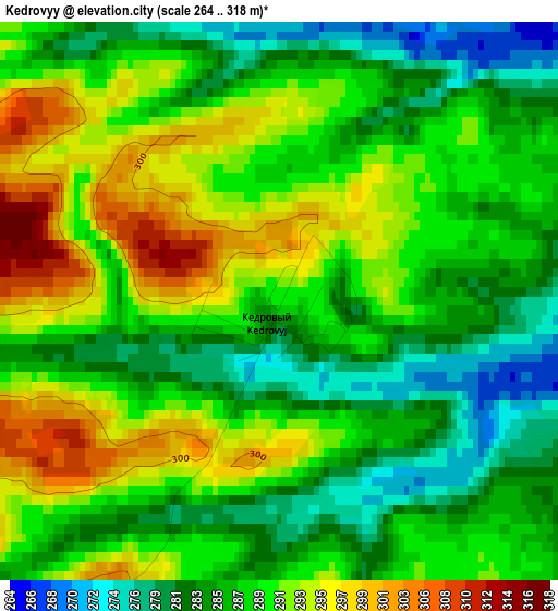
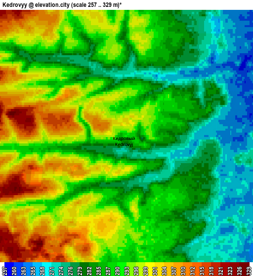
Below is the Elevation map of Kedrovyy, which displays elevation range with different colors. Scale of the first map is from 264 to 318 m (866 to 1043 ft) with average elevation of 288.3 meters (=946 ft) [note 1]
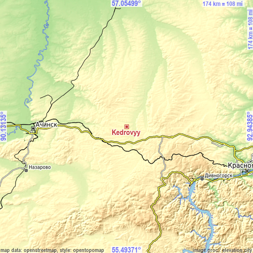
These maps also provides idea of topography and contour of this city, they are displayed at different zoom levels. More info about maps, scale and edge coordinates you can find below images.
| \ | Map #1 | Map #2 | Topo.Map |
| Scale [m] | 264..318 m | 257..329 m | × |
| Scale [ft] | 866..1043 ft | 843..1079 ft | × |
| Average | 288.3 m = 946 ft | 288.3 m = 946 ft | × |
| Width | 5.42 km = 3.4 mi | 10.85 km = 6.7 mi | 173.6 km = 107.9 mi |
| Height | 5.42 km = 3.4 mi | 10.85 km = 6.7 mi | 173.6 km = 107.9 mi |
| ↑Max Latitude | 56.306706° | 56.331077° | 57.05499° |
| Latitude at center | 56.28232° | 56.28232° | 56.28232° |
| ↓Min Latitude | 56.257918° | 56.233501° | 55.49371° |
| ← Min Longitude | 91.493655° | 91.449709° | 90.13135° |
| Longitude center | 91.5376° | 91.5376° | 91.5376° |
| →Max Longitude | 91.581545° | 91.625491° | 92.94385° |
Nearby cities:
Cities around Kedrovyy sort by population:
• Krasnoyarsk elevation 140 m
87.4 km,  109°
109°
• Achinsk 207 m
64.1 km,  268°
268°
• Nazarovo 253 m
76.6 km,  246°
246°
• Divnogorsk 247 m
63.1 km,  124°
124°
• Berëzovka 144 m
101.4 km, 106°
• Yemel’yanovo 211 m
71.5 km,  100°
100°
• Solnechnyy 315 m
87.8 km, 102°
• Balakhta 321 m
100 km,  177°
177°
• Novobirilyussy 177 m
91.1 km,  324°
324°
• Ovsyanka 171 m
73.5 km, 119°
• Novochernorechenskiy 280 m
27.5 km, 266°
• Rassvet 206 m
79.8 km,  357°
357°
Multilingual:
 En español:
Kedrovyy elevación 290 m.
 En France:
Kedrovyy élévation 290 m.
 Auf Deutsch:
Kedrovyy höhe über dem Meeresspiegel ist 290 m.

Sources and notes:
- [note 1] Map square and city borders are not equal. Map elevation data is calculated only from area inside that square.
- [src 1] Elevation data from geonames database provided with same terms of usage.
- [src 2] The elevation map of Kedrovyy is generated using elevation data from NASA's 3 arcsec (90m) resolution SRTM data.
- [src 3] Base (background) map © OpenStreetMap contributors tiles are generated by Geofabrik and OpenTopoMap.
Copyright & License:
This Kedrovyy Elevation Map is licensed under CC BY-SA. You may reuse any part from this page, if you give a proper credit by linking to this URL:
 More info on terms of use page.