Shchelkun elevation
Shchelkun (Sverdlovsk), Russia elevation is 262 meters and Shchelkun elevation in feet is 860 ft above sea level [src 1]. Shchelkun is a populated place (feature code) with elevation that is 63 meters (207 ft) bigger than average city elevation in Russia.
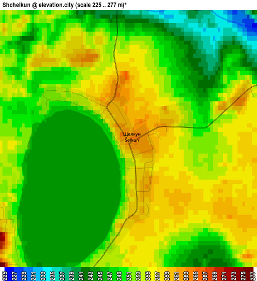
Below is the Elevation map of Shchelkun, which displays elevation range with different colors. Scale of the first map is from 225 to 277 m (738 to 909 ft) with average elevation of 251 meters (=823 ft) [note 1]
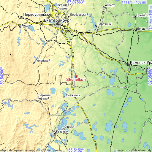
These maps also provides idea of topography and contour of this city, they are displayed at different zoom levels. More info about maps, scale and edge coordinates you can find below images.
| \ | Map #1 | Topo.Map |
| Scale [m] | 225..277 m | × |
| Scale [ft] | 738..909 ft | × |
| Average | 251 m = 823 ft | × |
| Width | 5.42 km = 3.4 mi | 173.5 km = 107.8 mi |
| Height | 5.42 km = 3.4 mi | 173.5 km = 107.8 mi |
| ↑Max Latitude | 56.327753° | 57.07563° |
| Latitude at center | 56.30338° | 56.30338° |
| ↓Min Latitude | 56.278992° | 55.5152° |
| ← Min Longitude | 60.904365° | 59.54206° |
| Longitude center | 60.94831° | 60.94831° |
| →Max Longitude | 60.992255° | 62.35456° |
Nearby cities:
Cities around Shchelkun sort by population:
• Snezhinsk elevation 275 m
27.7 km,  208°
208°
• Sysert’ 240 m
23.5 km,  340°
340°
• Aramil 215 m
44.4 km,  351°
351°
• Vishnëvogorsk 288 m
39.1 km, 207°
• Bobrovskiy 211 m
41.2 km,  2°
2°
• Dvurechensk 198 m
34 km,  15°
15°
• Shabrovskiy 321 m
43.3 km,  328°
328°
• Pokrovskoye 187 m
44.7 km,  65°
65°
• Tyubuk 236 m
27.6 km,  181°
181°
• Sovkhoznyy 227 m
40.9 km,  45°
45°
• Cheremshanka 425 m
46.8 km,  244°
244°
• Verkhnyaya Sysert’ 248 m
19.3 km,  322°
322°
Multilingual:
 En español:
Shchelkun elevación 262 m.
 En France:
Shchelkun élévation 262 m.
 Auf Deutsch:
Shchelkun höhe über dem Meeresspiegel ist 262 m.

Sources and notes:
- [note 1] Map square and city borders are not equal. Map elevation data is calculated only from area inside that square.
- [src 1] Elevation data from geonames database provided with same terms of usage.
- [src 2] The elevation map of Shchelkun is generated using elevation data from NASA's 3 arcsec (90m) resolution SRTM data.
- [src 3] Base (background) map © OpenStreetMap contributors tiles are generated by Geofabrik and OpenTopoMap.
Copyright & License:
This Shchelkun Elevation Map is licensed under CC BY-SA. You may reuse any part from this page, if you give a proper credit by linking to this URL:
 More info on terms of use page.