Tashara elevation
Tashara (Novosibirsk Oblast), Russia elevation is 124 meters and Tashara elevation in feet is 407 ft above sea level [src 1]. Tashara is a populated place (feature code) with elevation that is 75 meters (246 ft) smaller than average city elevation in Russia.
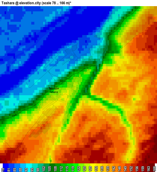
Below is the Elevation map of Tashara, which displays elevation range with different colors. Scale of the first map is from 78 to 166 m (256 to 545 ft) with average elevation of 119 meters (=390 ft) [note 1]
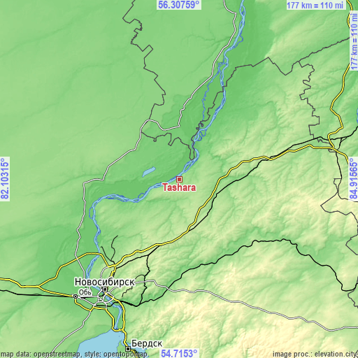
These maps also provides idea of topography and contour of this city, they are displayed at different zoom levels. More info about maps, scale and edge coordinates you can find below images.
| \ | Map #1 | Topo.Map |
| Scale [m] | 78..166 m | × |
| Scale [ft] | 256..545 ft | × |
| Average | 119 m = 390 ft | × |
| Width | 5.53 km = 3.4 mi | 177 km = 110 mi |
| Height | 5.53 km = 3.4 mi | 177 km = 110 mi |
| ↑Max Latitude | 55.544371° | 56.30759° |
| Latitude at center | 55.5195° | 55.5195° |
| ↓Min Latitude | 55.494614° | 54.7153° |
| ← Min Longitude | 83.465455° | 82.10315° |
| Longitude center | 83.5094° | 83.5094° |
| →Max Longitude | 83.553345° | 84.91565° |
Nearby cities:
Cities around Tashara sort by population:
• Novosibirsk elevation 164 m
64.4 km,  214°
214°
• Toguchin 149 m
63.8 km,  119°
119°
• Bolotnoye 203 m
58.3 km,  73°
73°
• Kolyvan’ 141 m
54.1 km,  243°
243°
• Moshkovo 216 m
24.7 km,  165°
165°
• Gornyy 245 m
51.5 km,  150°
150°
• Sokur 229 m
36.5 km,  199°
199°
• Stantsionno-Oyashinskiy 175 m
20.7 km,  106°
106°
• Mochishche 226 m
47 km, 211°
• Novolugovoye 111 m
65.1 km, 202°
• Sadovyy 197 m
54.8 km,  218°
218°
• Dubrovino 115 m
14.8 km,  248°
248°
Multilingual:
 En español:
Tashara elevación 124 m.
 En France:
Tashara élévation 124 m.


Sources and notes:
- [note 1] Map square and city borders are not equal. Map elevation data is calculated only from area inside that square.
- [src 1] Elevation data from geonames database provided with same terms of usage.
- [src 2] The elevation map of Tashara is generated using elevation data from NASA's 3 arcsec (90m) resolution SRTM data.
- [src 3] Base (background) map © OpenStreetMap contributors tiles are generated by Geofabrik and OpenTopoMap.
Copyright & License:
This Tashara Elevation Map is licensed under CC BY-SA. You may reuse any part from this page, if you give a proper credit by linking to this URL:
 More info on terms of use page.