Kolyvan’ elevation
Kolyvan’ (Novosibirsk Oblast), Russia elevation is 141 meters and Kolyvan’ elevation in feet is 463 ft above sea level [src 1]. Kolyvan’ is a populated place (feature code) with elevation that is 58 meters (190 ft) smaller than average city elevation in Russia.
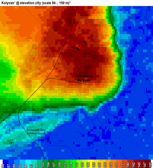
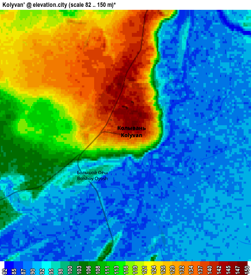
Below is the Elevation map of Kolyvan’, which displays elevation range with different colors. Scale of the first map is from 84 to 150 m (276 to 492 ft) with average elevation of 110.9 meters (=364 ft) [note 1]
These maps also provides idea of topography and contour of this city, they are displayed at different zoom levels. More info about maps, scale and edge coordinates you can find below images.
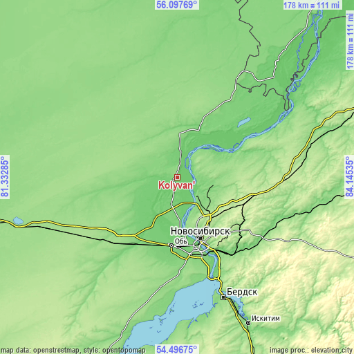
| \ | Map #1 | Map #2 | Topo.Map |
| Scale [m] | 84..150 m | 82..150 m | × |
| Scale [ft] | 276..492 ft | 269..492 ft | × |
| Average | 110.9 m = 364 ft | 103.8 m = 341 ft | × |
| Width | 5.56 km = 3.5 mi | 11.13 km = 6.9 mi | 178 km = 110.6 mi |
| Height | 5.56 km = 3.5 mi | 11.13 km = 6.9 mi | 178 km = 110.6 mi |
| ↑Max Latitude | 55.330306° | 55.355296° | 56.09769° |
| Latitude at center | 55.3053° | 55.3053° | 55.3053° |
| ↓Min Latitude | 55.280278° | 55.255241° | 54.49675° |
| ← Min Longitude | 82.695155° | 82.651209° | 81.33285° |
| Longitude center | 82.7391° | 82.7391° | 82.7391° |
| →Max Longitude | 82.783045° | 82.826991° | 84.14535° |
Nearby cities:
Cities around Kolyvan’ sort by population:
• Novosibirsk elevation 164 m
31.9 km,  157°
157°
• Ob’ 108 m
35.4 km,  182°
182°
• Krasnoobsk 114 m
45.8 km, 159°
• Krivodanovka 99 m
24.7 km,  192°
192°
• Prokudskoye 115 m
37.5 km,  208°
208°
• Sokur 229 m
38.3 km,  106°
106°
• Kudryashovskiy 103 m
23.2 km,  174°
174°
• Tolmachëvo 108 m
35.9 km, 180°
• Mochishche 226 m
29.3 km,  123°
123°
• Novolugovoye 111 m
43.4 km,  146°
146°
• Sadovyy 197 m
23.7 km,  142°
142°
• Dubrovino 115 m
39.5 km,  62°
62°
Multilingual:
 En español:
Kolyvan’ elevación 141 m.
 En France:
Kolyvan’ élévation 141 m.
 Auf Deutsch:
Kolyvan’ höhe über dem Meeresspiegel ist 141 m.

Sources and notes:
- [note 1] Map square and city borders are not equal. Map elevation data is calculated only from area inside that square.
- [src 1] Elevation data from geonames database provided with same terms of usage.
- [src 2] The elevation map of Kolyvan’ is generated using elevation data from NASA's 3 arcsec (90m) resolution SRTM data.
- [src 3] Base (background) map © OpenStreetMap contributors tiles are generated by Geofabrik and OpenTopoMap.
Copyright & License:
This Kolyvan’ Elevation Map is licensed under CC BY-SA. You may reuse any part from this page, if you give a proper credit by linking to this URL:
 More info on terms of use page.