Abdulino elevation
Abdulino (Orenburg Oblast), Russia elevation is 205 meters and Abdulino elevation in feet is 673 ft above sea level [src 1]. Abdulino is a populated place (feature code) with elevation that is 6 meters (20 ft) bigger than average city elevation in Russia.
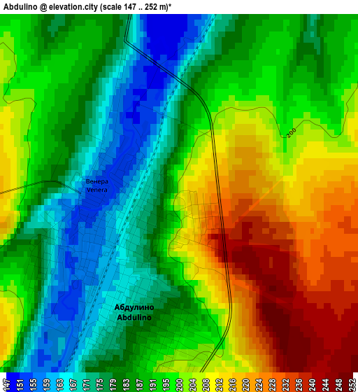
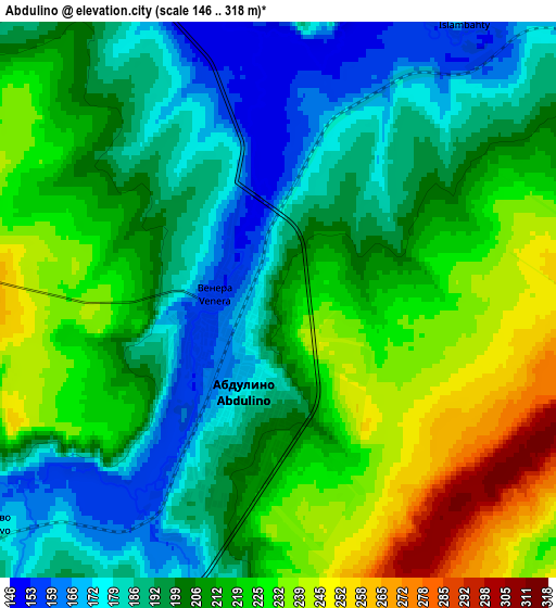
Below is the Elevation map of Abdulino, which displays elevation range with different colors. Scale of the first map is from 147 to 252 m (482 to 827 ft) with average elevation of 194.3 meters (=637 ft) [note 1]
These maps also provides idea of topography and contour of this city, they are displayed at different zoom levels. More info about maps, scale and edge coordinates you can find below images.
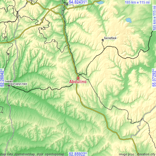
| \ | Map #1 | Map #2 | Topo.Map |
| Scale [m] | 147..252 m | 146..318 m | × |
| Scale [ft] | 482..827 ft | 479..1043 ft | × |
| Average | 194.3 m = 637 ft | 207.3 m = 680 ft | × |
| Width | 5.79 km = 3.6 mi | 11.57 km = 7.2 mi | 185.1 km = 115 mi |
| Height | 5.79 km = 3.6 mi | 11.57 km = 7.2 mi | 185.1 km = 115 mi |
| ↑Max Latitude | 53.726008° | 53.752° | 54.52431° |
| Latitude at center | 53.7° | 53.7° | 53.7° |
| ↓Min Latitude | 53.673976° | 53.647935° | 52.85922° |
| ← Min Longitude | 53.622725° | 53.578779° | 52.26042° |
| Longitude center | 53.66667° | 53.66667° | 53.66667° |
| →Max Longitude | 53.710615° | 53.754561° | 55.07292° |
Nearby cities:
Cities around Abdulino sort by population:
• Belebey elevation 295 m
54.9 km,  32°
32°
• Buguruslan 87 m
80.8 km,  266°
266°
• Bavly 180 m
81.5 km,  341°
341°
• Priyutovo 295 m
28.3 km,  38°
38°
• Serafimovskiy 271 m
81 km,  6°
6°
• Kirgiz-Miyaki 221 m
74.9 km,  95°
95°
• Bizhbulyak 252 m
39.3 km,  90°
90°
• Asekeyevo 86 m
59 km,  256°
256°
• Yermekeyevo 150 m
41.8 km,  0°
0°
• Nizhnetroitskiy 158 m
71 km, 0°
• Aksakovo 330 m
48.8 km, 40°
• Shafranovo 288 m
78 km,  67°
67°
Multilingual:
 En español:
Abdulino elevación 205 m.
 En France:
Abdoulino élévation 205 m.
 Auf Deutsch:
Abdulino höhe über dem Meeresspiegel ist 205 m.

Sources and notes:
- [note 1] Map square and city borders are not equal. Map elevation data is calculated only from area inside that square.
- [src 1] Elevation data from geonames database provided with same terms of usage.
- [src 2] The elevation map of Abdulino is generated using elevation data from NASA's 3 arcsec (90m) resolution SRTM data.
- [src 3] Base (background) map © OpenStreetMap contributors tiles are generated by Geofabrik and OpenTopoMap.
Copyright & License:
This Abdulino Elevation Map is licensed under CC BY-SA. You may reuse any part from this page, if you give a proper credit by linking to this URL:
 More info on terms of use page.