Yermekeyevo elevation
Yermekeyevo (Bashkortostan Republic), Russia elevation is 150 meters and Yermekeyevo elevation in feet is 492 ft above sea level [src 1]. Yermekeyevo is a populated place (feature code) with elevation that is 49 meters (161 ft) smaller than average city elevation in Russia.
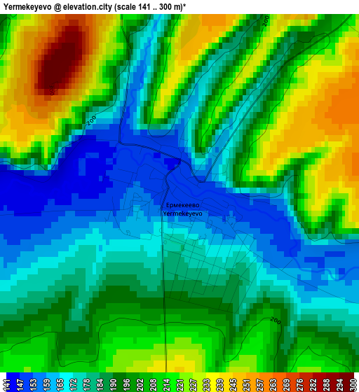
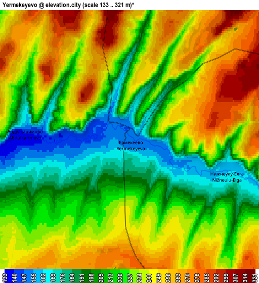
Below is the Elevation map of Yermekeyevo, which displays elevation range with different colors. Scale of the first map is from 141 to 300 m (463 to 984 ft) with average elevation of 195.7 meters (=642 ft) [note 1]
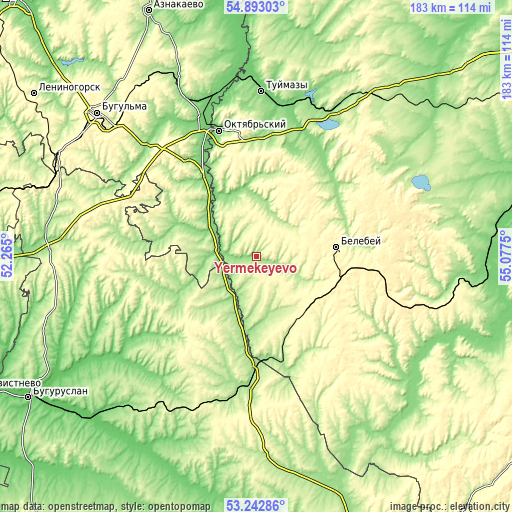
These maps also provides idea of topography and contour of this city, they are displayed at different zoom levels. More info about maps, scale and edge coordinates you can find below images.
| \ | Map #1 | Map #2 | Topo.Map |
| Scale [m] | 141..300 m | 133..321 m | × |
| Scale [ft] | 463..984 ft | 436..1053 ft | × |
| Average | 195.7 m = 642 ft | 227.8 m = 747 ft | × |
| Width | 5.73 km = 3.6 mi | 11.47 km = 7.1 mi | 183.5 km = 114 mi |
| Height | 5.73 km = 3.6 mi | 11.47 km = 7.1 mi | 183.5 km = 114 mi |
| ↑Max Latitude | 54.101915° | 54.127674° | 54.89303° |
| Latitude at center | 54.07614° | 54.07614° | 54.07614° |
| ↓Min Latitude | 54.050349° | 54.024542° | 53.24286° |
| ← Min Longitude | 53.627305° | 53.583359° | 52.265° |
| Longitude center | 53.67125° | 53.67125° | 53.67125° |
| →Max Longitude | 53.715195° | 53.759141° | 55.0775° |
Nearby cities:
Cities around Yermekeyevo sort by population:
• Oktyabr’skiy elevation 133 m
46.9 km,  343°
343°
• Tuymazy 113 m
59 km,  2°
2°
• Belebey 295 m
29.4 km,  81°
81°
• Bavly 180 m
44.2 km,  322°
322°
• Abdulino 205 m
41.8 km,  180°
180°
• Priyutovo 295 m
26 km,  138°
138°
• Urussu 107 m
59.6 km,  346°
346°
• Serafimovskiy 271 m
39.5 km,  11°
11°
• Bizhbulyak 252 m
57.4 km, 137°
• Subkhankulovo 119 m
54.3 km, 9°
• Nizhnetroitskiy 158 m
29.2 km, 1°
• Aksakovo 330 m
31.6 km,  98°
98°
Multilingual:
 En español:
Yermekeyevo elevación 150 m.
 En France:
Yermekeyevo élévation 150 m.
 Auf Deutsch:
Yermekeyevo höhe über dem Meeresspiegel ist 150 m.

Sources and notes:
- [note 1] Map square and city borders are not equal. Map elevation data is calculated only from area inside that square.
- [src 1] Elevation data from geonames database provided with same terms of usage.
- [src 2] The elevation map of Yermekeyevo is generated using elevation data from NASA's 3 arcsec (90m) resolution SRTM data.
- [src 3] Base (background) map © OpenStreetMap contributors tiles are generated by Geofabrik and OpenTopoMap.
Copyright & License:
This Yermekeyevo Elevation Map is licensed under CC BY-SA. You may reuse any part from this page, if you give a proper credit by linking to this URL:
 More info on terms of use page.