Alatyr’ elevation
Alatyr’ (Chuvashia), Russia elevation is 135 meters and Alatyr’ elevation in feet is 443 ft above sea level [src 1]. Alatyr’ is a populated place (feature code) with elevation that is 64 meters (210 ft) smaller than average city elevation in Russia.
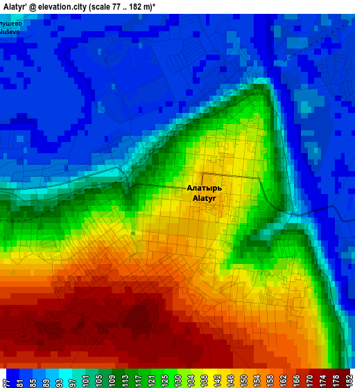
Below is the Elevation map of Alatyr’, which displays elevation range with different colors. Scale of the first map is from 77 to 182 m (253 to 597 ft) with average elevation of 117.8 meters (=386 ft) [note 1]
These maps also provides idea of topography and contour of this city, they are displayed at different zoom levels. More info about maps, scale and edge coordinates you can find below images.

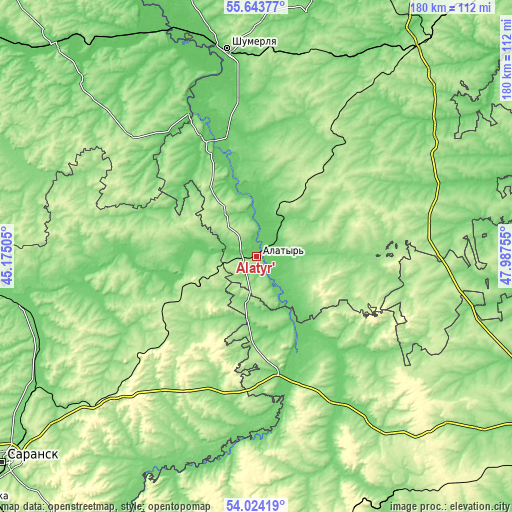
| \ | Map #1 | Map #2 | Topo.Map |
| Scale [m] | 77..182 m | 76..196 m | × |
| Scale [ft] | 253..597 ft | 249..643 ft | × |
| Average | 117.8 m = 386 ft | 109.1 m = 358 ft | × |
| Width | 5.63 km = 3.5 mi | 11.25 km = 7 mi | 180.1 km = 111.9 mi |
| Height | 5.63 km = 3.5 mi | 11.25 km = 7 mi | 180.1 km = 111.9 mi |
| ↑Max Latitude | 54.867397° | 54.892678° | 55.64377° |
| Latitude at center | 54.8421° | 54.8421° | 54.8421° |
| ↓Min Latitude | 54.816787° | 54.791458° | 54.02419° |
| ← Min Longitude | 46.537355° | 46.493409° | 45.17505° |
| Longitude center | 46.5813° | 46.5813° | 46.5813° |
| →Max Longitude | 46.625245° | 46.669191° | 47.98755° |
Nearby cities:
Cities around Alatyr’ sort by population:
• Ibresi elevation 191 m
58.7 km,  29°
29°
• Ardatov 147 m
21.9 km,  271°
271°
• Surskoye 122 m
41 km,  167°
167°
• Poretskoye 114 m
42.7 km,  337°
337°
• Atyashevo 215 m
45.1 km,  226°
226°
• Turgenevo 97 m
16.1 km, 271°
• Sechenovo 171 m
61.2 km,  314°
314°
• Shemursha 160 m
60.2 km,  85°
85°
• Staroye Drozhzhanoye 178 m
64.5 km,  101°
101°
• Krasnaya Gorka 93 m
67.6 km,  333°
333°
• Kirya 216 m
32 km, 33°
• Buinsk 164 m
49.7 km,  37°
37°
Multilingual:
 En español:
Alatyr’ elevación 135 m.
 En France:
Alatyr’ élévation 135 m.


Sources and notes:
- [note 1] Map square and city borders are not equal. Map elevation data is calculated only from area inside that square.
- [src 1] Elevation data from geonames database provided with same terms of usage.
- [src 2] The elevation map of Alatyr’ is generated using elevation data from NASA's 3 arcsec (90m) resolution SRTM data.
- [src 3] Base (background) map © OpenStreetMap contributors tiles are generated by Geofabrik and OpenTopoMap.
Copyright & License:
This Alatyr’ Elevation Map is licensed under CC BY-SA. You may reuse any part from this page, if you give a proper credit by linking to this URL:
 More info on terms of use page.