Atemar elevation
Atemar (Mordoviya Republic), Russia elevation is 217 meters and Atemar elevation in feet is 712 ft above sea level [src 1]. Atemar is a populated place (feature code) with elevation that is 18 meters (59 ft) bigger than average city elevation in Russia.
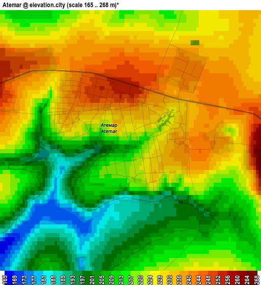
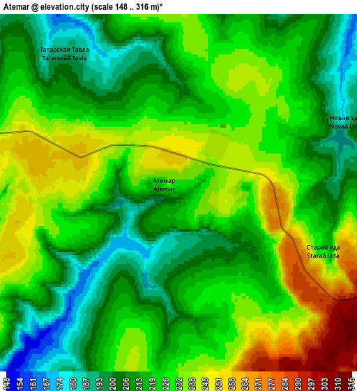
Below is the Elevation map of Atemar, which displays elevation range with different colors. Scale of the first map is from 165 to 268 m (541 to 879 ft) with average elevation of 220 meters (=722 ft) [note 1]
These maps also provides idea of topography and contour of this city, they are displayed at different zoom levels. More info about maps, scale and edge coordinates you can find below images.
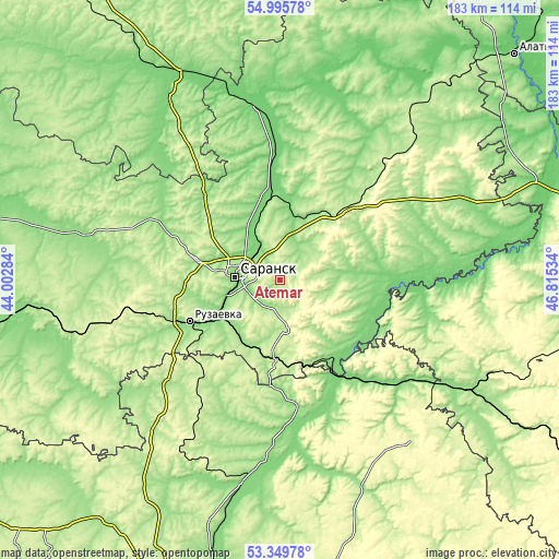
| \ | Map #1 | Map #2 | Topo.Map |
| Scale [m] | 165..268 m | 148..316 m | × |
| Scale [ft] | 541..879 ft | 486..1037 ft | × |
| Average | 220 m = 722 ft | 222.5 m = 730 ft | × |
| Width | 5.72 km = 3.6 mi | 11.44 km = 7.1 mi | 183 km = 113.7 mi |
| Height | 5.72 km = 3.6 mi | 11.44 km = 7.1 mi | 183 km = 113.7 mi |
| ↑Max Latitude | 54.20668° | 54.232374° | 54.99578° |
| Latitude at center | 54.18097° | 54.18097° | 54.18097° |
| ↓Min Latitude | 54.155244° | 54.129502° | 53.34978° |
| ← Min Longitude | 45.365145° | 45.321199° | 44.00284° |
| Longitude center | 45.40909° | 45.40909° | 45.40909° |
| →Max Longitude | 45.453035° | 45.496981° | 46.81534° |
Nearby cities:
Cities around Atemar sort by population:
• Saransk elevation 173 m
15.2 km,  271°
271°
• Ruzayevka 199 m
32.6 km,  246°
246°
• Romodanovo 114 m
27.9 km,  349°
349°
• Chamzinka 217 m
34.6 km,  44°
44°
• Lukhovka 139 m
10.5 km, 249°
• Lyambir’ 190 m
21.6 km,  301°
301°
• Issa 174 m
49.9 km,  226°
226°
• Nikolayevka 147 m
17.7 km,  256°
256°
• Kochkurovo 181 m
16.2 km,  177°
177°
• Tatarskaya Pishlya 157 m
35.8 km, 248°
• Sura 135 m
39.2 km,  146°
146°
• Zykovo 133 m
24.5 km,  239°
239°
Multilingual:
 En español:
Atemar elevación 217 m.
 En France:
Atemar élévation 217 m.


Sources and notes:
- [note 1] Map square and city borders are not equal. Map elevation data is calculated only from area inside that square.
- [src 1] Elevation data from geonames database provided with same terms of usage.
- [src 2] The elevation map of Atemar is generated using elevation data from NASA's 3 arcsec (90m) resolution SRTM data.
- [src 3] Base (background) map © OpenStreetMap contributors tiles are generated by Geofabrik and OpenTopoMap.
Copyright & License:
This Atemar Elevation Map is licensed under CC BY-SA. You may reuse any part from this page, if you give a proper credit by linking to this URL:
 More info on terms of use page.