Nikolayevka elevation
Nikolayevka (Mordoviya Republic), Russia elevation is 147 meters and Nikolayevka elevation in feet is 482 ft above sea level [src 1]. Nikolayevka is a populated place (feature code) with elevation that is 52 meters (171 ft) smaller than average city elevation in Russia.
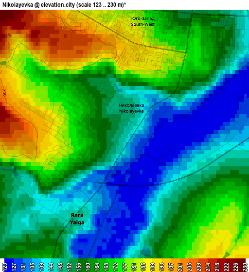
Below is the Elevation map of Nikolayevka, which displays elevation range with different colors. Scale of the first map is from 123 to 230 m (404 to 755 ft) with average elevation of 161 meters (=528 ft) [note 1]
These maps also provides idea of topography and contour of this city, they are displayed at different zoom levels. More info about maps, scale and edge coordinates you can find below images.
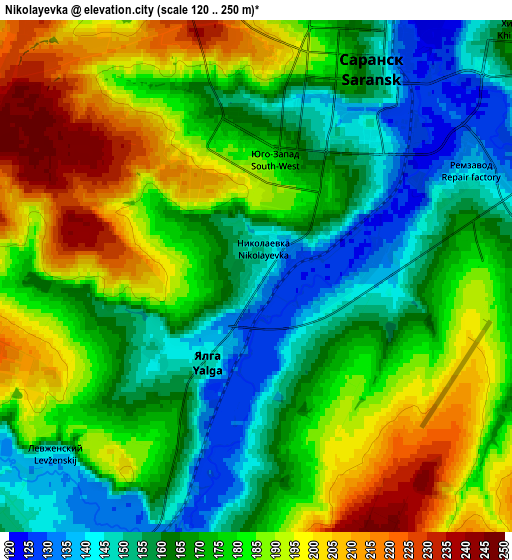
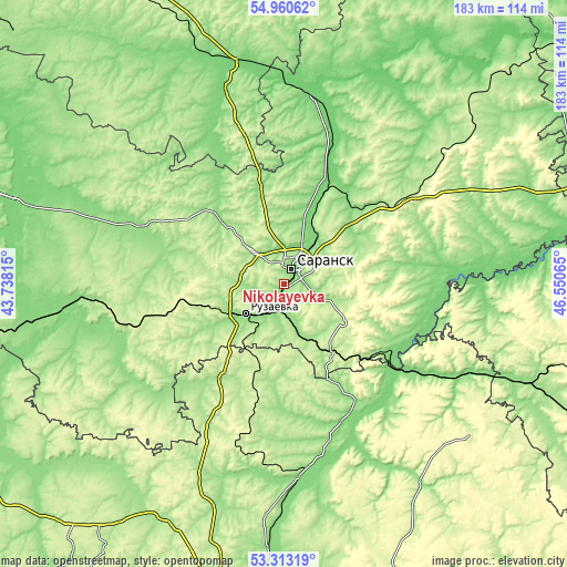
| \ | Map #1 | Map #2 | Topo.Map |
| Scale [m] | 123..230 m | 120..250 m | × |
| Scale [ft] | 404..755 ft | 394..820 ft | × |
| Average | 161 m = 528 ft | 175.1 m = 574 ft | × |
| Width | 5.72 km = 3.6 mi | 11.45 km = 7.1 mi | 183.2 km = 113.8 mi |
| Height | 5.72 km = 3.6 mi | 11.45 km = 7.1 mi | 183.2 km = 113.8 mi |
| ↑Max Latitude | 54.170832° | 54.196549° | 54.96062° |
| Latitude at center | 54.1451° | 54.1451° | 54.1451° |
| ↓Min Latitude | 54.119352° | 54.093587° | 53.31319° |
| ← Min Longitude | 45.100455° | 45.056509° | 43.73815° |
| Longitude center | 45.1444° | 45.1444° | 45.1444° |
| →Max Longitude | 45.188345° | 45.232291° | 46.55065° |
Nearby cities:
Cities around Nikolayevka sort by population:
• Saransk elevation 173 m
4.7 km,  24°
24°
• Ruzayevka 199 m
15.5 km,  234°
234°
• Romodanovo 114 m
33.6 km, 20°
• Lukhovka 139 m
7.4 km,  87°
87°
• Lyambir’ 190 m
15.2 km,  355°
355°
• Issa 174 m
35.8 km,  211°
211°
• Kadoshkino 237 m
49.1 km,  254°
254°
• Atemar 217 m
17.7 km,  76°
76°
• Kochkurovo 181 m
21.6 km,  124°
124°
• Tatarskaya Pishlya 157 m
18.5 km,  239°
239°
• Sura 135 m
48.4 km,  126°
126°
• Zykovo 133 m
9.3 km,  203°
203°
Multilingual:
 En español:
Nikolayevka elevación 147 m.
 En France:
Nikolayevka élévation 147 m.
 Auf Deutsch:
Nikolayevka höhe über dem Meeresspiegel ist 147 m.

Sources and notes:
- [note 1] Map square and city borders are not equal. Map elevation data is calculated only from area inside that square.
- [src 1] Elevation data from geonames database provided with same terms of usage.
- [src 2] The elevation map of Nikolayevka is generated using elevation data from NASA's 3 arcsec (90m) resolution SRTM data.
- [src 3] Base (background) map © OpenStreetMap contributors tiles are generated by Geofabrik and OpenTopoMap.
Copyright & License:
This Nikolayevka Elevation Map is licensed under CC BY-SA. You may reuse any part from this page, if you give a proper credit by linking to this URL:
 More info on terms of use page.