Baltay elevation
Baltay (Saratovskaya Oblast), Russia elevation is 129 meters and Baltay elevation in feet is 423 ft above sea level [src 1]. Baltay is a populated place (feature code) with elevation that is 70 meters (230 ft) smaller than average city elevation in Russia.
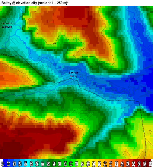
Below is the Elevation map of Baltay, which displays elevation range with different colors. Scale of the first map is from 111 to 259 m (364 to 850 ft) with average elevation of 175.9 meters (=577 ft) [note 1]
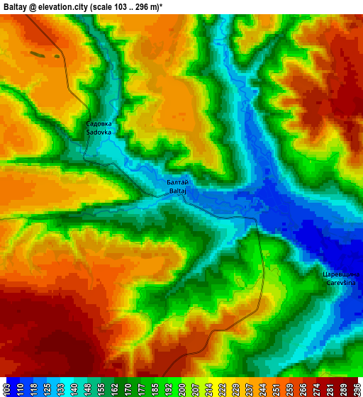
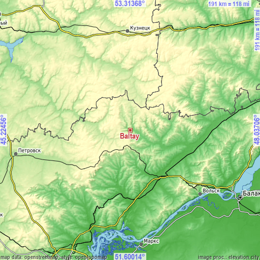
These maps also provides idea of topography and contour of this city, they are displayed at different zoom levels. More info about maps, scale and edge coordinates you can find below images.
| \ | Map #1 | Map #2 | Topo.Map |
| Scale [m] | 111..259 m | 103..296 m | × |
| Scale [ft] | 364..850 ft | 338..971 ft | × |
| Average | 175.9 m = 577 ft | 202.8 m = 665 ft | × |
| Width | 5.95 km = 3.7 mi | 11.91 km = 7.4 mi | 190.5 km = 118.4 mi |
| Height | 5.95 km = 3.7 mi | 11.91 km = 7.4 mi | 190.5 km = 118.4 mi |
| ↑Max Latitude | 52.492015° | 52.518764° | 53.31368° |
| Latitude at center | 52.46525° | 52.46525° | 52.46525° |
| ↓Min Latitude | 52.438469° | 52.411671° | 51.60014° |
| ← Min Longitude | 46.586865° | 46.542919° | 45.22456° |
| Longitude center | 46.63081° | 46.63081° | 46.63081° |
| →Max Longitude | 46.674755° | 46.718701° | 48.03706° |
Nearby cities:
Cities around Baltay sort by population:
• Bazarnyy Karabulak elevation 140 m
26.4 km,  213°
213°
• Sennoy 48 m
41.6 km,  147°
147°
• Shikhany 199 m
54.6 km,  135°
135°
• Novyye Burasy 228 m
53.1 km,  225°
225°
• Pavlovka 176 m
42.5 km,  54°
54°
• Russkiy Kameshkir 215 m
57.1 km,  320°
320°
• Neverkino 228 m
36.4 km,  11°
11°
• Lopatino 191 m
58 km,  287°
287°
• Cherkasskoye 89 m
39.5 km,  95°
95°
• Sinodskoye 26 m
52.7 km,  177°
177°
• Khvatovka 289 m
13.4 km,  200°
200°
• Svobodnyy 289 m
23.1 km, 229°
Multilingual:
 En español:
Baltay elevación 129 m.
 En France:
Baltay élévation 129 m.


Sources and notes:
- [note 1] Map square and city borders are not equal. Map elevation data is calculated only from area inside that square.
- [src 1] Elevation data from geonames database provided with same terms of usage.
- [src 2] The elevation map of Baltay is generated using elevation data from NASA's 3 arcsec (90m) resolution SRTM data.
- [src 3] Base (background) map © OpenStreetMap contributors tiles are generated by Geofabrik and OpenTopoMap.
Copyright & License:
This Baltay Elevation Map is licensed under CC BY-SA. You may reuse any part from this page, if you give a proper credit by linking to this URL:
 More info on terms of use page.