Sennoy elevation
Sennoy (Saratovskaya Oblast), Russia elevation is 48 meters and Sennoy elevation in feet is 157 ft above sea level [src 1]. Sennoy is a populated place (feature code) with elevation that is 151 meters (495 ft) smaller than average city elevation in Russia.
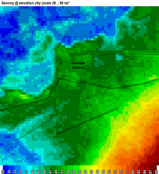
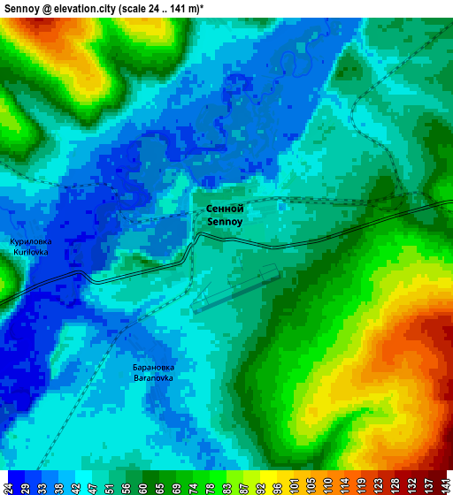
Below is the Elevation map of Sennoy, which displays elevation range with different colors. Scale of the first map is from 28 to 89 m (92 to 292 ft) with average elevation of 47.4 meters (=156 ft) [note 1]
These maps also provides idea of topography and contour of this city, they are displayed at different zoom levels. More info about maps, scale and edge coordinates you can find below images.
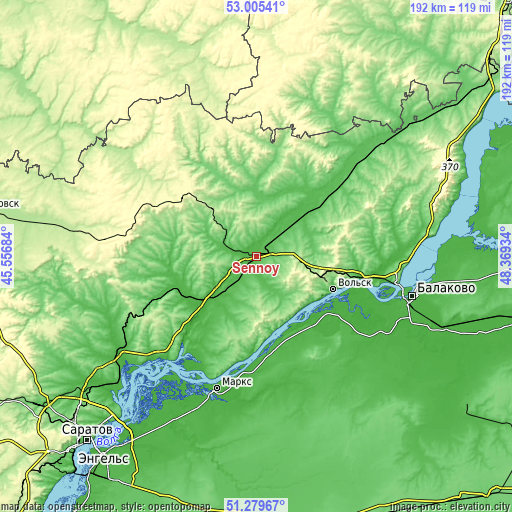
| \ | Map #1 | Map #2 | Topo.Map |
| Scale [m] | 28..89 m | 24..141 m | × |
| Scale [ft] | 92..292 ft | 79..463 ft | × |
| Average | 47.4 m = 156 ft | 56.3 m = 185 ft | × |
| Width | 6 km = 3.7 mi | 11.99 km = 7.5 mi | 191.9 km = 119.2 mi |
| Height | 6 km = 3.7 mi | 11.99 km = 7.5 mi | 191.9 km = 119.2 mi |
| ↑Max Latitude | 52.177856° | 52.204796° | 53.00541° |
| Latitude at center | 52.1509° | 52.1509° | 52.1509° |
| ↓Min Latitude | 52.123928° | 52.096939° | 51.27967° |
| ← Min Longitude | 46.919145° | 46.875199° | 45.55684° |
| Longitude center | 46.96309° | 46.96309° | 46.96309° |
| →Max Longitude | 47.007035° | 47.050981° | 48.36934° |
Nearby cities:
Cities around Sennoy sort by population:
• Vol’sk elevation 83 m
30.8 km,  112°
112°
• Marks 17 m
51.1 km,  196°
196°
• Bazarnyy Karabulak 140 m
39.6 km,  289°
289°
• Shikhany 199 m
16.5 km,  102°
102°
• Podlesnoye 27 m
37.4 km,  175°
175°
• Baltay 129 m
41.6 km,  327°
327°
• Cherkasskoye 89 m
35.2 km,  28°
28°
• Voskresenskoye 33 m
36.3 km, 183°
• Sinodskoye 26 m
26.7 km,  228°
228°
• Khvatovka 289 m
35.3 km,  309°
309°
• Svobodnyy 289 m
45 km,  296°
296°
• Tersa 27 m
40 km, 100°
Multilingual:
 En español:
Sennoy elevación 48 m.
 En France:
Sennoy élévation 48 m.


Sources and notes:
- [note 1] Map square and city borders are not equal. Map elevation data is calculated only from area inside that square.
- [src 1] Elevation data from geonames database provided with same terms of usage.
- [src 2] The elevation map of Sennoy is generated using elevation data from NASA's 3 arcsec (90m) resolution SRTM data.
- [src 3] Base (background) map © OpenStreetMap contributors tiles are generated by Geofabrik and OpenTopoMap.
Copyright & License:
This Sennoy Elevation Map is licensed under CC BY-SA. You may reuse any part from this page, if you give a proper credit by linking to this URL:
 More info on terms of use page.