Belyy Gorodok elevation
Belyy Gorodok (Tver’ Oblast), Russia elevation is 127 meters and Belyy Gorodok elevation in feet is 417 ft above sea level [src 1]. Belyy Gorodok is a populated place (feature code) with elevation that is 72 meters (236 ft) smaller than average city elevation in Russia.
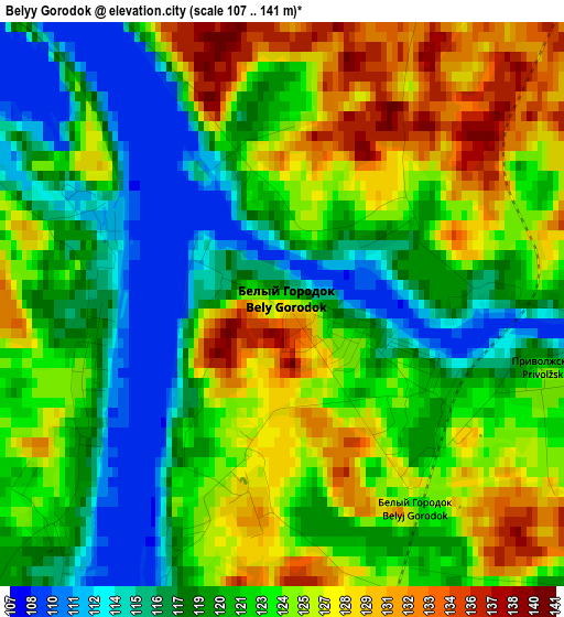
Below is the Elevation map of Belyy Gorodok, which displays elevation range with different colors. Scale of the first map is from 107 to 141 m (351 to 463 ft) with average elevation of 122.2 meters (=401 ft) [note 1]
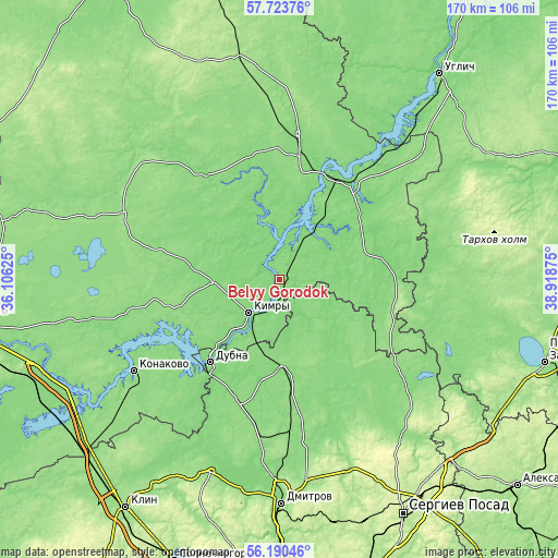
These maps also provides idea of topography and contour of this city, they are displayed at different zoom levels. More info about maps, scale and edge coordinates you can find below images.
| \ | Map #1 | Topo.Map |
| Scale [m] | 107..141 m | × |
| Scale [ft] | 351..463 ft | × |
| Average | 122.2 m = 401 ft | × |
| Width | 5.33 km = 3.3 mi | 170.5 km = 105.9 mi |
| Height | 5.33 km = 3.3 mi | 170.5 km = 105.9 mi |
| ↑Max Latitude | 56.988949° | 57.72376° |
| Latitude at center | 56.965° | 56.965° |
| ↓Min Latitude | 56.941035° | 56.19046° |
| ← Min Longitude | 37.468555° | 36.10625° |
| Longitude center | 37.5125° | 37.5125° |
| →Max Longitude | 37.556445° | 38.91875° |
Nearby cities:
Cities around Belyy Gorodok sort by population:
• Dubna elevation 126 m
33.3 km,  219°
219°
• Kimry 126 m
14.7 km, 222°
• Kashin 120 m
44.2 km,  7°
7°
• Kalyazin 116 m
36.6 km,  33°
33°
• Taldom 143 m
25.8 km,  177°
177°
• Zaprudnya 134 m
44.6 km,  186°
186°
• Vinogradovo 134 m
4.2 km,  147°
147°
• Bogorodskoye 179 m
51.4 km, 153°
• Verbilki 129 m
48.3 km,  173°
173°
• Severnyy 156 m
27.1 km,  162°
162°
• Il’inskoye 130 m
20 km,  270°
270°
• Novo-Nikol’skoye 136 m
44.3 km, 178°
Multilingual:
 En español:
Belyy Gorodok elevación 127 m.
 En France:
Belyy Gorodok élévation 127 m.
 Auf Deutsch:
Belyy Gorodok höhe über dem Meeresspiegel ist 127 m.
 На русском:
Белый-Городок, Белый Городок высота над уровнем моря 127 м
Sources and notes:
- [note 1] Map square and city borders are not equal. Map elevation data is calculated only from area inside that square.
- [src 1] Elevation data from geonames database provided with same terms of usage.
- [src 2] The elevation map of Belyy Gorodok is generated using elevation data from NASA's 3 arcsec (90m) resolution SRTM data.
- [src 3] Base (background) map © OpenStreetMap contributors tiles are generated by Geofabrik and OpenTopoMap.
Copyright & License:
This Belyy Gorodok Elevation Map is licensed under CC BY-SA. You may reuse any part from this page, if you give a proper credit by linking to this URL:
 More info on terms of use page.