Kimry elevation
Kimry (Tver’ Oblast), Russia elevation is 126 meters and Kimry elevation in feet is 413 ft above sea level [src 1]. Kimry is a populated place (feature code) with elevation that is 73 meters (240 ft) smaller than average city elevation in Russia.
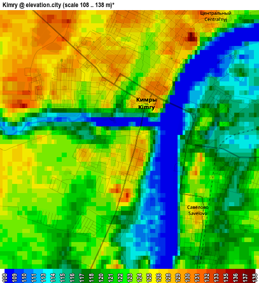
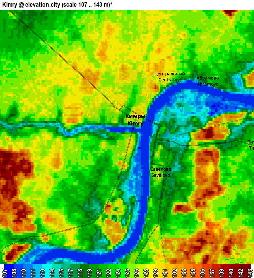
Below is the Elevation map of Kimry, which displays elevation range with different colors. Scale of the first map is from 108 to 138 m (354 to 453 ft) with average elevation of 121.2 meters (=398 ft) [note 1]
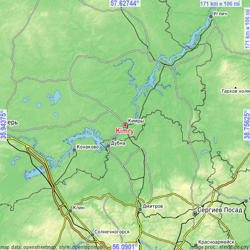
These maps also provides idea of topography and contour of this city, they are displayed at different zoom levels. More info about maps, scale and edge coordinates you can find below images.
| \ | Map #1 | Map #2 | Topo.Map |
| Scale [m] | 108..138 m | 107..143 m | × |
| Scale [ft] | 354..453 ft | 351..469 ft | × |
| Average | 121.2 m = 398 ft | 124.2 m = 407 ft | × |
| Width | 5.34 km = 3.3 mi | 10.68 km = 6.6 mi | 170.9 km = 106.2 mi |
| Height | 5.34 km = 3.3 mi | 10.68 km = 6.6 mi | 170.9 km = 106.2 mi |
| ↑Max Latitude | 56.890682° | 56.914679° | 57.62744° |
| Latitude at center | 56.86667° | 56.86667° | 56.86667° |
| ↓Min Latitude | 56.842642° | 56.818599° | 56.0901° |
| ← Min Longitude | 37.306055° | 37.262109° | 35.94375° |
| Longitude center | 37.35° | 37.35° | 37.35° |
| →Max Longitude | 37.393945° | 37.437891° | 38.75625° |
Nearby cities:
Cities around Kimry sort by population:
• Dubna elevation 126 m
18.6 km,  216°
216°
• Konakovo 129 m
40.1 km,  242°
242°
• Taldom 143 m
18.6 km,  143°
143°
• Zaprudnya 134 m
33.7 km,  171°
171°
• Vinogradovo 134 m
14.2 km,  58°
58°
• Verbilki 129 m
40.1 km,  157°
157°
• Severnyy 156 m
23.5 km,  129°
129°
• Belyy Gorodok 127 m
14.7 km,  42°
42°
• Zhukovka 159 m
43.8 km, 166°
• Il’inskoye 130 m
15 km,  317°
317°
• Novo-Nikol’skoye 136 m
35.2 km, 161°
• Ol'yavidovo 191 m
47.3 km,  148°
148°
Multilingual:
 En español:
Kimry elevación 126 m.
 En France:
Kimry élévation 126 m.


Sources and notes:
- [note 1] Map square and city borders are not equal. Map elevation data is calculated only from area inside that square.
- [src 1] Elevation data from geonames database provided with same terms of usage.
- [src 2] The elevation map of Kimry is generated using elevation data from NASA's 3 arcsec (90m) resolution SRTM data.
- [src 3] Base (background) map © OpenStreetMap contributors tiles are generated by Geofabrik and OpenTopoMap.
Copyright & License:
This Kimry Elevation Map is licensed under CC BY-SA. You may reuse any part from this page, if you give a proper credit by linking to this URL:
 More info on terms of use page.