Blagoveshchensk elevation
Blagoveshchensk (Bashkortostan Republic), Russia elevation is 109 meters and Blagoveshchensk elevation in feet is 358 ft above sea level [src 1]. Blagoveshchensk is a populated place (feature code) with elevation that is 90 meters (295 ft) smaller than average city elevation in Russia.
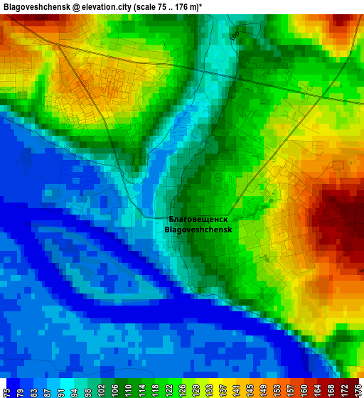
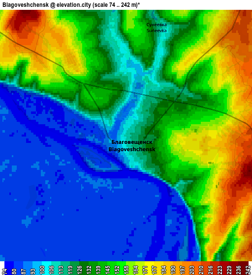
Below is the Elevation map of Blagoveshchensk, which displays elevation range with different colors. Scale of the first map is from 75 to 176 m (246 to 577 ft) with average elevation of 110.5 meters (=363 ft) [note 1]
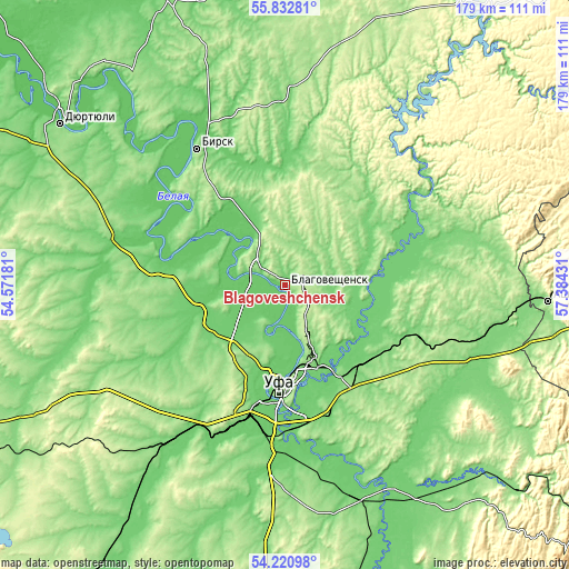
These maps also provides idea of topography and contour of this city, they are displayed at different zoom levels. More info about maps, scale and edge coordinates you can find below images.
| \ | Map #1 | Map #2 | Topo.Map |
| Scale [m] | 75..176 m | 74..242 m | × |
| Scale [ft] | 246..577 ft | 243..794 ft | × |
| Average | 110.5 m = 363 ft | 127.1 m = 417 ft | × |
| Width | 5.6 km = 3.5 mi | 11.2 km = 7 mi | 179.2 km = 111.3 mi |
| Height | 5.6 km = 3.5 mi | 11.2 km = 7 mi | 179.2 km = 111.3 mi |
| ↑Max Latitude | 55.060176° | 55.085336° | 55.83281° |
| Latitude at center | 55.035° | 55.035° | 55.035° |
| ↓Min Latitude | 55.009808° | 54.9846° | 54.22098° |
| ← Min Longitude | 55.934115° | 55.890169° | 54.57181° |
| Longitude center | 55.97806° | 55.97806° | 55.97806° |
| →Max Longitude | 56.022005° | 56.065951° | 57.38431° |
Nearby cities:
Cities around Blagoveshchensk sort by population:
• Ufa elevation 158 m
32.5 km,  181°
181°
• Birsk 150 m
51 km,  327°
327°
• Iglino 114 m
35.7 km,  129°
129°
• Kushnarënkovo 88 m
40.7 km,  281°
281°
• Yazykovo 174 m
22.9 km,  25°
25°
• Avdon 177 m
44.2 km,  202°
202°
• Mikhaylovka 97 m
26.2 km,  192°
192°
• Krasnaya Gorka 122 m
47.4 km,  67°
67°
• Alekseyevka 157 m
51.8 km,  246°
246°
• Chesnokovka 95 m
47 km, 182°
• Asanovo 91 m
34.8 km,  243°
243°
• Bedeyeva Polyana 122 m
41.3 km,  39°
39°
Multilingual:
 En español:
Blagoveshchensk elevación 109 m.
 En France:
Blagovechtchensk élévation 109 m.
 Auf Deutsch:
Blagoweschtschensk höhe über dem Meeresspiegel ist 109 m.

Sources and notes:
- [note 1] Map square and city borders are not equal. Map elevation data is calculated only from area inside that square.
- [src 1] Elevation data from geonames database provided with same terms of usage.
- [src 2] The elevation map of Blagoveshchensk is generated using elevation data from NASA's 3 arcsec (90m) resolution SRTM data.
- [src 3] Base (background) map © OpenStreetMap contributors tiles are generated by Geofabrik and OpenTopoMap.
Copyright & License:
This Blagoveshchensk Elevation Map is licensed under CC BY-SA. You may reuse any part from this page, if you give a proper credit by linking to this URL:
 More info on terms of use page.