Kushnarënkovo elevation
Kushnarënkovo (Bashkortostan Republic), Russia elevation is 88 meters and Kushnarënkovo elevation in feet is 289 ft above sea level [src 1]. Kushnarënkovo is a populated place (feature code) with elevation that is 111 meters (364 ft) smaller than average city elevation in Russia.
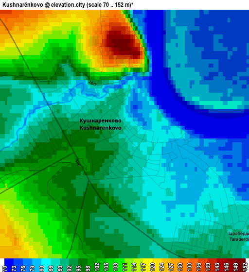
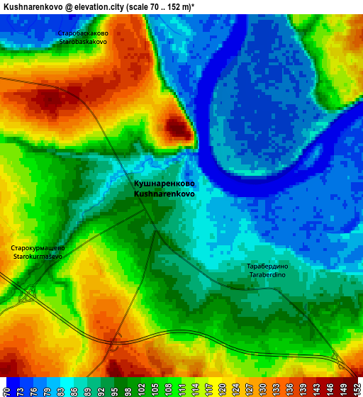
Below is the Elevation map of Kushnarënkovo, which displays elevation range with different colors. Scale of the first map is from 70 to 152 m (230 to 499 ft) with average elevation of 92.7 meters (=304 ft) [note 1]
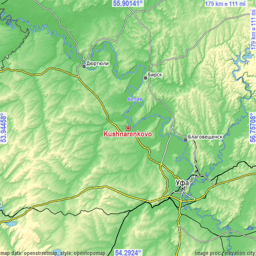
These maps also provides idea of topography and contour of this city, they are displayed at different zoom levels. More info about maps, scale and edge coordinates you can find below images.
| \ | Map #1 | Map #2 | Topo.Map |
| Scale [m] | 70..152 m | 70..152 m | × |
| Scale [ft] | 230..499 ft | 230..499 ft | × |
| Average | 92.7 m = 304 ft | 101 m = 331 ft | × |
| Width | 5.59 km = 3.5 mi | 11.18 km = 6.9 mi | 178.9 km = 111.2 mi |
| Height | 5.59 km = 3.5 mi | 11.18 km = 6.9 mi | 178.9 km = 111.2 mi |
| ↑Max Latitude | 55.130132° | 55.155248° | 55.90141° |
| Latitude at center | 55.105° | 55.105° | 55.105° |
| ↓Min Latitude | 55.079852° | 55.054688° | 54.2924° |
| ← Min Longitude | 55.306885° | 55.262939° | 53.94458° |
| Longitude center | 55.35083° | 55.35083° | 55.35083° |
| →Max Longitude | 55.394775° | 55.438721° | 56.75708° |
Nearby cities:
Cities around Kushnarënkovo sort by population:
• Ufa elevation 158 m
56.3 km,  135°
135°
• Birsk 150 m
37.2 km,  19°
19°
• Blagoveshchensk 109 m
40.7 km,  101°
101°
• Dyurtyuli 86 m
52.7 km,  324°
324°
• Chekmagush 148 m
44.3 km,  273°
273°
• Yazykovo 174 m
51.4 km,  75°
75°
• Avdon 177 m
54.1 km,  154°
154°
• Mikhaylovka 97 m
48 km,  133°
133°
• Semiletka 162 m
54.6 km,  301°
301°
• Alekseyevka 157 m
29.3 km,  194°
194°
• Dmitriyevka 160 m
39.5 km,  181°
181°
• Asanovo 91 m
25.1 km,  159°
159°
Multilingual:
 En español:
Kushnarënkovo elevación 88 m.
 En France:
Kushnarënkovo élévation 88 m.
 Auf Deutsch:
Kushnarënkovo höhe über dem Meeresspiegel ist 88 m.

Sources and notes:
- [note 1] Map square and city borders are not equal. Map elevation data is calculated only from area inside that square.
- [src 1] Elevation data from geonames database provided with same terms of usage.
- [src 2] The elevation map of Kushnarënkovo is generated using elevation data from NASA's 3 arcsec (90m) resolution SRTM data.
- [src 3] Base (background) map © OpenStreetMap contributors tiles are generated by Geofabrik and OpenTopoMap.
Copyright & License:
This Kushnarënkovo Elevation Map is licensed under CC BY-SA. You may reuse any part from this page, if you give a proper credit by linking to this URL:
 More info on terms of use page.