Chamlykskaya elevation
Chamlykskaya (Krasnodarskiy), Russia elevation is 313 meters and Chamlykskaya elevation in feet is 1027 ft above sea level [src 1]. Chamlykskaya is a populated place (feature code) with elevation that is 114 meters (374 ft) bigger than average city elevation in Russia.
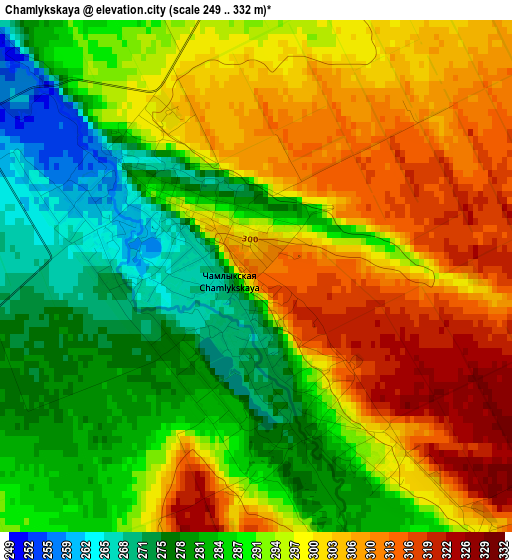
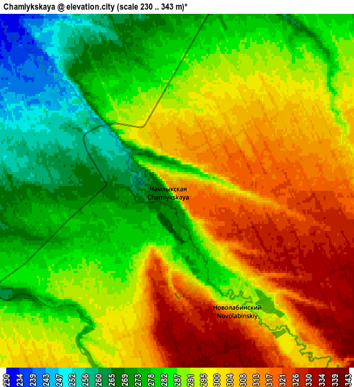
Below is the Elevation map of Chamlykskaya, which displays elevation range with different colors. Scale of the first map is from 249 to 332 m (817 to 1089 ft) with average elevation of 293.8 meters (=964 ft) [note 1]
These maps also provides idea of topography and contour of this city, they are displayed at different zoom levels. More info about maps, scale and edge coordinates you can find below images.
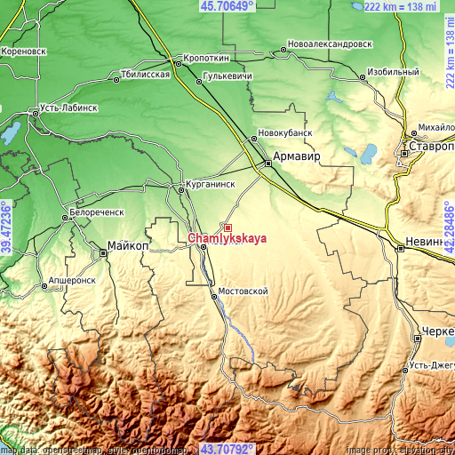
| \ | Map #1 | Map #2 | Topo.Map |
| Scale [m] | 249..332 m | 230..343 m | × |
| Scale [ft] | 817..1089 ft | 755..1125 ft | × |
| Average | 293.8 m = 964 ft | 292.4 m = 959 ft | × |
| Width | 6.94 km = 4.3 mi | 13.89 km = 8.6 mi | 222.2 km = 138.1 mi |
| Height | 6.94 km = 4.3 mi | 13.89 km = 8.6 mi | 222.2 km = 138.1 mi |
| ↑Max Latitude | 44.747049° | 44.778252° | 45.70649° |
| Latitude at center | 44.71583° | 44.71583° | 44.71583° |
| ↓Min Latitude | 44.684594° | 44.653341° | 43.70792° |
| ← Min Longitude | 40.834665° | 40.790719° | 39.47236° |
| Longitude center | 40.87861° | 40.87861° | 40.87861° |
| →Max Longitude | 40.922555° | 40.966501° | 42.28486° |
Nearby cities:
Cities around Chamlykskaya sort by population:
• Labinsk elevation 271 m
14.5 km,  231°
231°
• Kurganinsk 167 m
28.7 km,  309°
309°
• Sovetskaya 287 m
24.2 km,  73°
73°
• Rodnikovskaya 214 m
17.7 km,  287°
287°
• Vladimirskaya 316 m
20.1 km,  199°
199°
• Voznesenskaya 385 m
21.8 km,  146°
146°
• Zavetnyy 224 m
31.5 km,  40°
40°
• Konstantinovskaya 201 m
17.9 km,  317°
317°
• Novoalekseyevskaya 241 m
12.3 km,  20°
20°
• Glubokiy 240 m
27.9 km, 23°
• Natyrbovo 220 m
20 km,  274°
274°
• Khodz’ 321 m
26.3 km,  209°
209°
Multilingual:
 En español:
Chamlykskaya elevación 313 m.
 En France:
Chamlykskaya élévation 313 m.
 Auf Deutsch:
Chamlykskaya höhe über dem Meeresspiegel ist 313 m.

Sources and notes:
- [note 1] Map square and city borders are not equal. Map elevation data is calculated only from area inside that square.
- [src 1] Elevation data from geonames database provided with same terms of usage.
- [src 2] The elevation map of Chamlykskaya is generated using elevation data from NASA's 3 arcsec (90m) resolution SRTM data.
- [src 3] Base (background) map © OpenStreetMap contributors tiles are generated by Geofabrik and OpenTopoMap.
Copyright & License:
This Chamlykskaya Elevation Map is licensed under CC BY-SA. You may reuse any part from this page, if you give a proper credit by linking to this URL:
 More info on terms of use page.