Chastyye elevation
Chastyye (Perm), Russia elevation is 99 meters and Chastyye elevation in feet is 325 ft above sea level [src 1]. Chastyye is a populated place (feature code) with elevation that is 100 meters (328 ft) smaller than average city elevation in Russia.
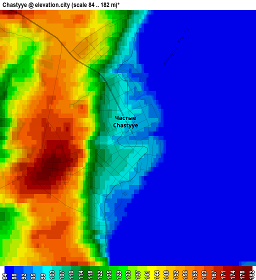
Below is the Elevation map of Chastyye, which displays elevation range with different colors. Scale of the first map is from 84 to 182 m (276 to 597 ft) with average elevation of 112.7 meters (=370 ft) [note 1]
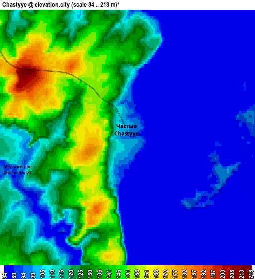
These maps also provides idea of topography and contour of this city, they are displayed at different zoom levels. More info about maps, scale and edge coordinates you can find below images.
| \ | Map #1 | Map #2 | Topo.Map |
| Scale [m] | 84..182 m | 84..218 m | × |
| Scale [ft] | 276..597 ft | 276..715 ft | × |
| Average | 112.7 m = 370 ft | 111.4 m = 365 ft | × |
| Width | 5.28 km = 3.3 mi | 10.56 km = 6.6 mi | 169 km = 105 mi |
| Height | 5.28 km = 3.3 mi | 10.56 km = 6.6 mi | 169 km = 105 mi |
| ↑Max Latitude | 57.312501° | 57.336226° | 58.04089° |
| Latitude at center | 57.28876° | 57.28876° | 57.28876° |
| ↓Min Latitude | 57.265004° | 57.241233° | 56.52094° |
| ← Min Longitude | 54.928835° | 54.884889° | 53.56653° |
| Longitude center | 54.97278° | 54.97278° | 54.97278° |
| →Max Longitude | 55.016725° | 55.060671° | 56.37903° |
Nearby cities:
Cities around Chastyye sort by population:
• Votkinsk elevation 85 m
65.1 km,  245°
245°
• Chaykovskiy 89 m
77.7 km,  221°
221°
• Osa 101 m
29.2 km,  91°
91°
• Nytva 136 m
76 km,  16°
16°
• Ochër 163 m
68.6 km,  347°
347°
• Barda 126 m
55 km,  136°
136°
• Okhansk 117 m
54 km,  27°
27°
• Yugo-Kamskiy 121 m
59 km,  38°
38°
• Sharkan 142 m
66.2 km,  270°
270°
• Yelovo 98 m
26.3 km,  186°
186°
• Foki 137 m
76.2 km,  209°
209°
• Pavlovskiy 118 m
62 km, 352°
Multilingual:
 En español:
Chastyye elevación 99 m.
 En France:
Chastyye élévation 99 m.


Sources and notes:
- [note 1] Map square and city borders are not equal. Map elevation data is calculated only from area inside that square.
- [src 1] Elevation data from geonames database provided with same terms of usage.
- [src 2] The elevation map of Chastyye is generated using elevation data from NASA's 3 arcsec (90m) resolution SRTM data.
- [src 3] Base (background) map © OpenStreetMap contributors tiles are generated by Geofabrik and OpenTopoMap.
Copyright & License:
This Chastyye Elevation Map is licensed under CC BY-SA. You may reuse any part from this page, if you give a proper credit by linking to this URL:
 More info on terms of use page.