Cherdyn’ elevation
Cherdyn’ (Perm), Russia elevation is 137 meters and Cherdyn’ elevation in feet is 449 ft above sea level [src 1]. Cherdyn’ is a populated place (feature code) with elevation that is 62 meters (203 ft) smaller than average city elevation in Russia.
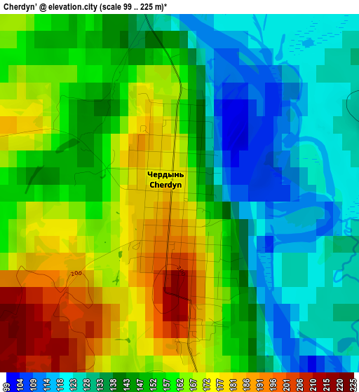
Below is the Elevation map of Cherdyn’, which displays elevation range with different colors. Scale of the first map is from 99 to 225 m (325 to 738 ft) with average elevation of 151.6 meters (=497 ft) [note 1]
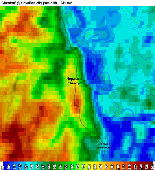
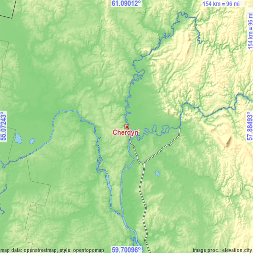
These maps also provides idea of topography and contour of this city, they are displayed at different zoom levels. More info about maps, scale and edge coordinates you can find below images.
| \ | Map #1 | Map #2 | Topo.Map |
| Scale [m] | 99..225 m | 99..241 m | × |
| Scale [ft] | 325..738 ft | 325..791 ft | × |
| Average | 151.6 m = 497 ft | 155.1 m = 509 ft | × |
| Width | 4.83 km = 3 mi | 9.65 km = 6 mi | 154.5 km = 96 mi |
| Height | 4.83 km = 3 mi | 9.65 km = 6 mi | 154.4 km = 95.9 mi |
| ↑Max Latitude | 60.424647° | 60.44633° | 61.09012° |
| Latitude at center | 60.40295° | 60.40295° | 60.40295° |
| ↓Min Latitude | 60.381238° | 60.359512° | 59.70096° |
| ← Min Longitude | 56.434735° | 56.390789° | 55.07243° |
| Longitude center | 56.47868° | 56.47868° | 56.47868° |
| →Max Longitude | 56.522625° | 56.566571° | 57.88493° |
Nearby cities:
Cities around Cherdyn’ sort by population:
• Berezniki elevation 189 m
112.1 km,  170°
170°
• Solikamsk 144 m
87.3 km, 169°
• Krasnovishersk 132 m
33.1 km,  89°
89°
• Aleksandrovsk 174 m
151.3 km,  156°
156°
• Yayva 137 m
126.5 km, 159°
• Nyrob 147 m
39 km,  19°
19°
• Usol’ye 123 m
109.7 km, 173°
• Gayny 130 m
119 km,  264°
264°
• Pozhva 149 m
147.5 km,  188°
188°
• Kochevo 175 m
150 km,  233°
233°
• Kerchevskiy 133 m
51.8 km, 191°
• Kosa 187 m
96.8 km,  238°
238°
Multilingual:
 En español:
Cherdyn’ elevación 137 m.
 En France:
Cherdyn’ élévation 137 m.
 Auf Deutsch:
Cherdyn’ höhe über dem Meeresspiegel ist 137 m.

Sources and notes:
- [note 1] Map square and city borders are not equal. Map elevation data is calculated only from area inside that square.
- [src 1] Elevation data from geonames database provided with same terms of usage.
- [src 2] The elevation map of Cherdyn’ is generated using GMTED2010 database with 7.5 arcsec (225m) resolution.
- [src 3] Base (background) map © OpenStreetMap contributors tiles are generated by Geofabrik and OpenTopoMap.
Copyright & License:
This Cherdyn’ Elevation Map is licensed under CC BY-SA. You may reuse any part from this page, if you give a proper credit by linking to this URL:
 More info on terms of use page.