Dankov elevation
Dankov (Lipetsk Oblast), Russia elevation is 144 meters and Dankov elevation in feet is 472 ft above sea level [src 1]. Dankov is a populated place (feature code) with elevation that is 55 meters (180 ft) smaller than average city elevation in Russia.
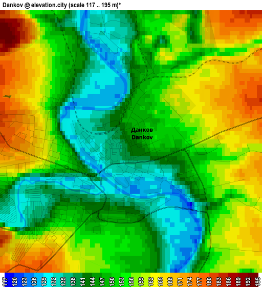
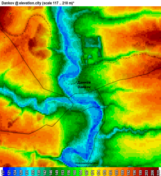
Below is the Elevation map of Dankov, which displays elevation range with different colors. Scale of the first map is from 117 to 195 m (384 to 640 ft) with average elevation of 151.6 meters (=497 ft) [note 1]
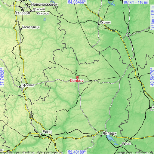
These maps also provides idea of topography and contour of this city, they are displayed at different zoom levels. More info about maps, scale and edge coordinates you can find below images.
| \ | Map #1 | Map #2 | Topo.Map |
| Scale [m] | 117..195 m | 117..210 m | × |
| Scale [ft] | 384..640 ft | 384..689 ft | × |
| Average | 151.6 m = 497 ft | 165.9 m = 544 ft | × |
| Width | 5.85 km = 3.6 mi | 11.69 km = 7.3 mi | 187.1 km = 116.3 mi |
| Height | 5.85 km = 3.6 mi | 11.69 km = 7.3 mi | 187.1 km = 116.3 mi |
| ↑Max Latitude | 53.277835° | 53.304103° | 54.08466° |
| Latitude at center | 53.25155° | 53.25155° | 53.25155° |
| ↓Min Latitude | 53.225249° | 53.198932° | 52.40189° |
| ← Min Longitude | 39.111585° | 39.067639° | 37.74928° |
| Longitude center | 39.15553° | 39.15553° | 39.15553° |
| →Max Longitude | 39.199475° | 39.243421° | 40.56178° |
Nearby cities:
Cities around Dankov sort by population:
• Skopin elevation 155 m
68.9 km,  22°
22°
• Lebedyan’ 128 m
25.8 km,  178°
178°
• Chaplygin 148 m
53.7 km,  90°
90°
• Lev Tolstoy 210 m
19.8 km,  102°
102°
• Kurkino 233 m
38.3 km,  300°
300°
• Dobroye 110 m
61.1 km,  134°
134°
• Miloslavskoye 179 m
41.2 km,  27°
27°
• Krasnoye 218 m
49.4 km,  209°
209°
• Kalikino 108 m
56 km, 126°
• Zarechnyy 140 m
60.7 km, 28°
• Pavelets 206 m
60 km,  5°
5°
• Kuz’minskiye Otverzhki 169 m
65.3 km,  161°
161°
Multilingual:
 En español:
Dankov elevación 144 m.
 En France:
Dankov élévation 144 m.


Sources and notes:
- [note 1] Map square and city borders are not equal. Map elevation data is calculated only from area inside that square.
- [src 1] Elevation data from geonames database provided with same terms of usage.
- [src 2] The elevation map of Dankov is generated using elevation data from NASA's 3 arcsec (90m) resolution SRTM data.
- [src 3] Base (background) map © OpenStreetMap contributors tiles are generated by Geofabrik and OpenTopoMap.
Copyright & License:
This Dankov Elevation Map is licensed under CC BY-SA. You may reuse any part from this page, if you give a proper credit by linking to this URL:
 More info on terms of use page.