Kurkino elevation
Kurkino (Tula), Russia elevation is 233 meters and Kurkino elevation in feet is 764 ft above sea level [src 1]. Kurkino is a populated place (feature code) with elevation that is 34 meters (112 ft) bigger than average city elevation in Russia.
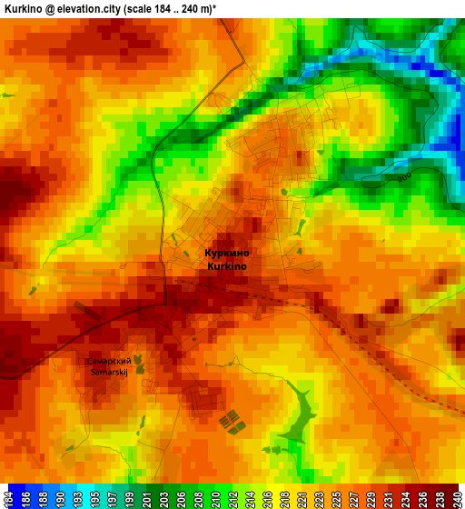
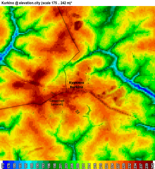
Below is the Elevation map of Kurkino, which displays elevation range with different colors. Scale of the first map is from 184 to 240 m (604 to 787 ft) with average elevation of 221.6 meters (=727 ft) [note 1]
These maps also provides idea of topography and contour of this city, they are displayed at different zoom levels. More info about maps, scale and edge coordinates you can find below images.
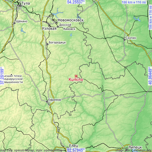
| \ | Map #1 | Map #2 | Topo.Map |
| Scale [m] | 184..240 m | 175..242 m | × |
| Scale [ft] | 604..787 ft | 574..794 ft | × |
| Average | 221.6 m = 727 ft | 216.1 m = 709 ft | × |
| Width | 5.82 km = 3.6 mi | 11.65 km = 7.2 mi | 186.3 km = 115.8 mi |
| Height | 5.82 km = 3.6 mi | 11.65 km = 7.2 mi | 186.3 km = 115.8 mi |
| ↑Max Latitude | 53.451847° | 53.478009° | 54.25537° |
| Latitude at center | 53.42567° | 53.42567° | 53.42567° |
| ↓Min Latitude | 53.399476° | 53.373267° | 52.57945° |
| ← Min Longitude | 38.614295° | 38.570349° | 37.25199° |
| Longitude center | 38.65824° | 38.65824° | 38.65824° |
| →Max Longitude | 38.702185° | 38.746131° | 40.06449° |
Nearby cities:
Cities around Kurkino sort by population:
• Yefremov elevation 207 m
48.3 km,  230°
230°
• Bogoroditsk 239 m
52.2 km,  317°
317°
• Lebedyan’ 128 m
56.4 km,  143°
143°
• Dankov 144 m
38.3 km,  120°
120°
• Tovarkovskiy 223 m
41.1 km,  313°
313°
• Miloslavskoye 179 m
54.5 km,  71°
71°
• Volovo 276 m
45.8 km,  288°
288°
• Zhdankovskiy 246 m
48.2 km, 319°
• Begichevskiy 210 m
49 km,  327°
327°
• Yepifan’ 199 m
45 km,  351°
351°
• Pavelets 206 m
55.9 km,  43°
43°
• Kazachka 203 m
39.6 km,  260°
260°
Multilingual:
 En español:
Kurkino elevación 233 m.
 En France:
Kurkino élévation 233 m.


Sources and notes:
- [note 1] Map square and city borders are not equal. Map elevation data is calculated only from area inside that square.
- [src 1] Elevation data from geonames database provided with same terms of usage.
- [src 2] The elevation map of Kurkino is generated using elevation data from NASA's 3 arcsec (90m) resolution SRTM data.
- [src 3] Base (background) map © OpenStreetMap contributors tiles are generated by Geofabrik and OpenTopoMap.
Copyright & License:
This Kurkino Elevation Map is licensed under CC BY-SA. You may reuse any part from this page, if you give a proper credit by linking to this URL:
 More info on terms of use page.