Ferzikovo elevation
Ferzikovo (Kaluga), Russia elevation is 230 meters and Ferzikovo elevation in feet is 755 ft above sea level [src 1]. Ferzikovo is a populated place (feature code) with elevation that is 31 meters (102 ft) bigger than average city elevation in Russia.
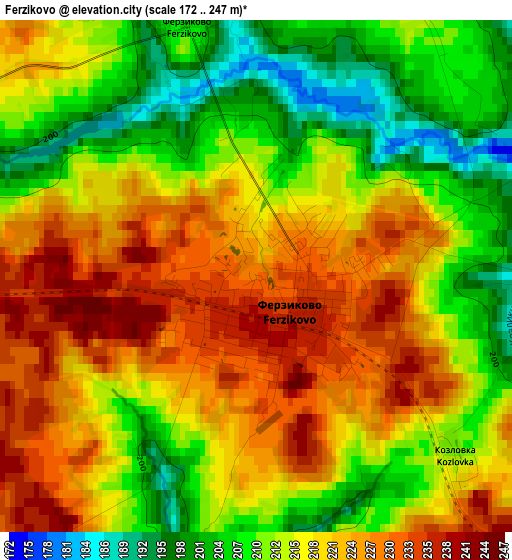
Below is the Elevation map of Ferzikovo, which displays elevation range with different colors. Scale of the first map is from 172 to 247 m (564 to 810 ft) with average elevation of 216.5 meters (=710 ft) [note 1]
These maps also provides idea of topography and contour of this city, they are displayed at different zoom levels. More info about maps, scale and edge coordinates you can find below images.
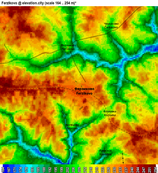
| \ | Map #1 | Map #2 | Topo.Map |
| Scale [m] | 172..247 m | 164..254 m | × |
| Scale [ft] | 564..810 ft | 538..833 ft | × |
| Average | 216.5 m = 710 ft | 216.4 m = 710 ft | × |
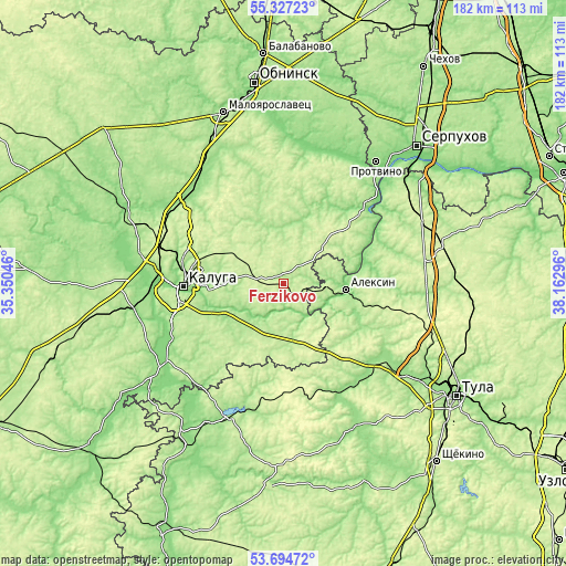
| Width | 5.67 km = 3.5 mi | 11.34 km = 7 mi | 181.5 km = 112.8 mi |
| Height | 5.67 km = 3.5 mi | 11.34 km = 7 mi | 181.5 km = 112.8 mi |
| ↑Max Latitude | 54.544629° | 54.570113° | 55.32723° |
| Latitude at center | 54.51913° | 54.51913° | 54.51913° |
| ↓Min Latitude | 54.493615° | 54.468084° | 53.69472° |
| ← Min Longitude | 36.712765° | 36.668819° | 35.35046° |
| Longitude center | 36.75671° | 36.75671° | 36.75671° |
| →Max Longitude | 36.800655° | 36.844601° | 38.16296° |
Nearby cities:
Cities around Ferzikovo sort by population:
• Kaluga elevation 200 m
31.1 km,  272°
272°
• Aleksin 154 m
20.1 km,  94°
94°
• Kremenki 133 m
47 km,  29°
29°
• Vorotynsk 134 m
47 km,  257°
257°
• Tarusa 165 m
35.2 km,  49°
49°
• Dubna 177 m
42.7 km,  161°
161°
• Ageyevo 173 m
44.2 km,  204°
204°
• Detchino 161 m
43.3 km,  318°
318°
• Novogurovskiy 218 m
37.9 km,  98°
98°
• Mstikhino 154 m
40.8 km,  276°
276°
• Vysokinichi 125 m
44.8 km,  14°
14°
• Khanino 196 m
35.3 km,  194°
194°
Multilingual:
 En español:
Ferzikovo elevación 230 m.
 En France:
Ferzikovo élévation 230 m.
 Auf Deutsch:
Ferzikovo höhe über dem Meeresspiegel ist 230 m.

Sources and notes:
- [note 1] Map square and city borders are not equal. Map elevation data is calculated only from area inside that square.
- [src 1] Elevation data from geonames database provided with same terms of usage.
- [src 2] The elevation map of Ferzikovo is generated using elevation data from NASA's 3 arcsec (90m) resolution SRTM data.
- [src 3] Base (background) map © OpenStreetMap contributors tiles are generated by Geofabrik and OpenTopoMap.
Copyright & License:
This Ferzikovo Elevation Map is licensed under CC BY-SA. You may reuse any part from this page, if you give a proper credit by linking to this URL:
 More info on terms of use page.