Fosforitnyy elevation
Fosforitnyy (Moscow Oblast), Russia elevation is 132 meters and Fosforitnyy elevation in feet is 433 ft above sea level [src 1]. Fosforitnyy is a populated place (feature code) with elevation that is 67 meters (220 ft) smaller than average city elevation in Russia.
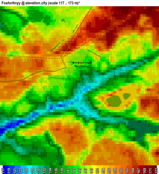
Below is the Elevation map of Fosforitnyy, which displays elevation range with different colors. Scale of the first map is from 117 to 173 m (384 to 568 ft) with average elevation of 148.5 meters (=487 ft) [note 1]
These maps also provides idea of topography and contour of this city, they are displayed at different zoom levels. More info about maps, scale and edge coordinates you can find below images.
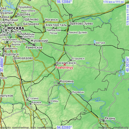
| \ | Map #1 | Map #2 | Topo.Map |
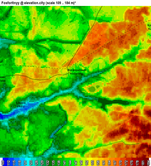
| Scale [m] | 117..173 m | 109..184 m | × |
| Scale [ft] | 384..568 ft | 358..604 ft | × |
| Average | 148.5 m = 487 ft | 150.5 m = 494 ft | × |
| Width | 5.56 km = 3.5 mi | 11.12 km = 6.9 mi | 177.9 km = 110.5 mi |
| Height | 5.56 km = 3.5 mi | 11.12 km = 6.9 mi | 177.9 km = 110.5 mi |
| ↑Max Latitude | 55.353911° | 55.378886° | 56.12084° |
| Latitude at center | 55.32892° | 55.32892° | 55.32892° |
| ↓Min Latitude | 55.303913° | 55.278891° | 54.52085° |
| ← Min Longitude | 38.851145° | 38.807199° | 37.48884° |
| Longitude center | 38.89509° | 38.89509° | 38.89509° |
| →Max Longitude | 38.939035° | 38.982981° | 40.30134° |
Nearby cities:
Cities around Fosforitnyy sort by population:
• Yegor’yevsk elevation 143 m
10.5 km,  55°
55°
• Voskresensk 124 m
15.4 km,  265°
265°
• Lopatinskiy 122 m
10.9 km,  277°
277°
• Konobeyevo 119 m
17.1 km,  300°
300°
• Troitskoye 150 m
23.1 km,  262°
262°
• Il’inskiy Pogost 129 m
16.6 km,  3°
3°
• Imeni Tsyurupy 131 m
24.1 km,  320°
320°
• Khorlovo 143 m
5.2 km, 274°
• Peski 114 m
15.1 km,  213°
213°
• Ashitkovo 115 m
23.3 km,  305°
305°
• Krasnyy Tkach 132 m
19.7 km,  36°
36°
• Raduzhnyy 114 m
23.8 km, 206°
Multilingual:
 En español:
Fosforitnyy elevación 132 m.
 En France:
Fosforitnyy élévation 132 m.
 Auf Deutsch:
Fosforitnyy höhe über dem Meeresspiegel ist 132 m.

Sources and notes:
- [note 1] Map square and city borders are not equal. Map elevation data is calculated only from area inside that square.
- [src 1] Elevation data from geonames database provided with same terms of usage.
- [src 2] The elevation map of Fosforitnyy is generated using elevation data from NASA's 3 arcsec (90m) resolution SRTM data.
- [src 3] Base (background) map © OpenStreetMap contributors tiles are generated by Geofabrik and OpenTopoMap.
Copyright & License:
This Fosforitnyy Elevation Map is licensed under CC BY-SA. You may reuse any part from this page, if you give a proper credit by linking to this URL:
 More info on terms of use page.