Krasnyy Tkach elevation
Krasnyy Tkach (Moscow Oblast), Russia elevation is 132 meters and Krasnyy Tkach elevation in feet is 433 ft above sea level [src 1]. Krasnyy Tkach is a populated place (feature code) with elevation that is 67 meters (220 ft) smaller than average city elevation in Russia.
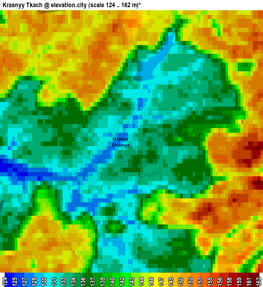
Below is the Elevation map of Krasnyy Tkach, which displays elevation range with different colors. Scale of the first map is from 124 to 162 m (407 to 531 ft) with average elevation of 140.8 meters (=462 ft) [note 1]
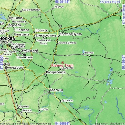
These maps also provides idea of topography and contour of this city, they are displayed at different zoom levels. More info about maps, scale and edge coordinates you can find below images.
| \ | Map #1 | Topo.Map |
| Scale [m] | 124..162 m | × |
| Scale [ft] | 407..531 ft | × |
| Average | 140.8 m = 462 ft | × |
| Width | 5.54 km = 3.4 mi | 177.3 km = 110.2 mi |
| Height | 5.54 km = 3.4 mi | 177.2 km = 110.1 mi |
| ↑Max Latitude | 55.497001° | 56.26114° |
| Latitude at center | 55.4721° | 55.4721° |
| ↓Min Latitude | 55.447184° | 54.66694° |
| ← Min Longitude | 39.036225° | 37.67392° |
| Longitude center | 39.08017° | 39.08017° |
| →Max Longitude | 39.124115° | 40.48642° |
Nearby cities:
Cities around Krasnyy Tkach sort by population:
• Yegor’yevsk elevation 143 m
10.4 km,  196°
196°
• Kurovskoye 118 m
15.8 km,  320°
320°
• Lopatinskiy 122 m
26.8 km,  237°
237°
• Davydovo 126 m
20.5 km, 317°
• Konobeyevo 119 m
27.3 km,  254°
254°
• Avsyunino 149 m
10.7 km,  14°
14°
• Fosforitnyy 132 m
19.7 km,  216°
216°
• Il’inskiy Pogost 129 m
10.8 km,  273°
273°
• Imeni Tsyurupy 131 m
27.2 km,  275°
275°
• Khorlovo 143 m
22.9 km,  227°
227°
• Shaturtorf 137 m
23.9 km,  63°
63°
• Novoye 128 m
20.3 km,  330°
330°
Multilingual:
 En español:
Krasnyy Tkach elevación 132 m.
 En France:
Krasnyy Tkach élévation 132 m.
 Auf Deutsch:
Krasnyy Tkach höhe über dem Meeresspiegel ist 132 m.
 На русском:
Красн.Ткач, Красный Ткач высота над уровнем моря 132 м
Sources and notes:
- [note 1] Map square and city borders are not equal. Map elevation data is calculated only from area inside that square.
- [src 1] Elevation data from geonames database provided with same terms of usage.
- [src 2] The elevation map of Krasnyy Tkach is generated using elevation data from NASA's 3 arcsec (90m) resolution SRTM data.
- [src 3] Base (background) map © OpenStreetMap contributors tiles are generated by Geofabrik and OpenTopoMap.
Copyright & License:
This Krasnyy Tkach Elevation Map is licensed under CC BY-SA. You may reuse any part from this page, if you give a proper credit by linking to this URL:
 More info on terms of use page.