Furmanov elevation
Furmanov (Ivanovo), Russia elevation is 125 meters and Furmanov elevation in feet is 410 ft above sea level [src 1]. Furmanov is a populated place (feature code) with elevation that is 74 meters (243 ft) smaller than average city elevation in Russia.
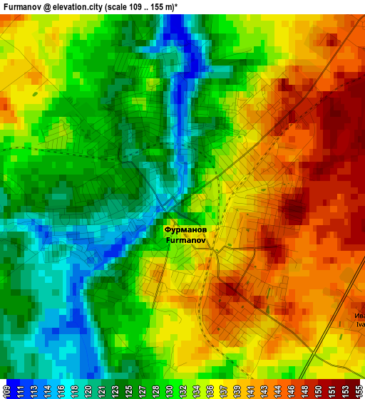
Below is the Elevation map of Furmanov, which displays elevation range with different colors. Scale of the first map is from 109 to 155 m (358 to 509 ft) with average elevation of 132.6 meters (=435 ft) [note 1]
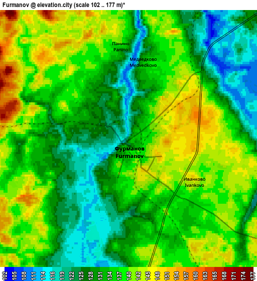
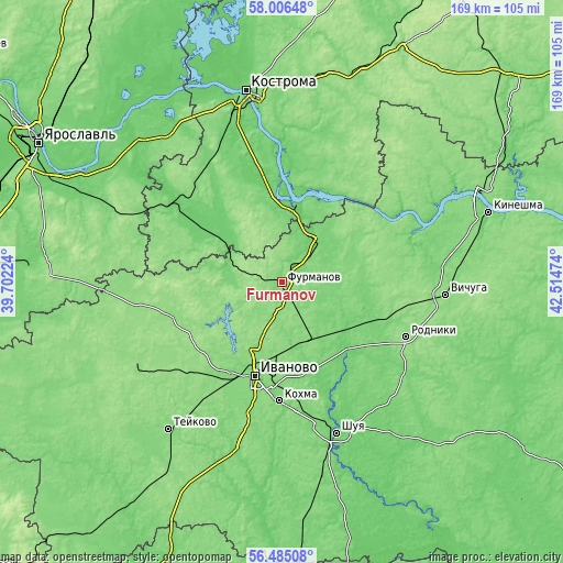
These maps also provides idea of topography and contour of this city, they are displayed at different zoom levels. More info about maps, scale and edge coordinates you can find below images.
| \ | Map #1 | Map #2 | Topo.Map |
| Scale [m] | 109..155 m | 102..177 m | × |
| Scale [ft] | 358..509 ft | 335..581 ft | × |
| Average | 132.6 m = 435 ft | 134.5 m = 441 ft | × |
| Width | 5.29 km = 3.3 mi | 10.57 km = 6.6 mi | 169.2 km = 105.1 mi |
| Height | 5.29 km = 3.3 mi | 10.57 km = 6.6 mi | 169.1 km = 105.1 mi |
| ↑Max Latitude | 57.277393° | 57.301141° | 58.00648° |
| Latitude at center | 57.25363° | 57.25363° | 57.25363° |
| ↓Min Latitude | 57.229851° | 57.206057° | 56.48508° |
| ← Min Longitude | 41.064545° | 41.020599° | 39.70224° |
| Longitude center | 41.10849° | 41.10849° | 41.10849° |
| →Max Longitude | 41.152435° | 41.196381° | 42.51474° |
Nearby cities:
Cities around Furmanov sort by population:
• Ivanovo elevation 126 m
29.7 km,  196°
196°
• Kokhma 120 m
35.5 km,  181°
181°
• Nerekhta 93 m
39.3 km,  305°
305°
• Privolzhsk 119 m
18.3 km,  35°
35°
• Volgorechensk 114 m
20.8 km,  7°
7°
• Novo-Talitsy 124 m
31.6 km,  208°
208°
• Krasnoye-na-Volge 126 m
30.1 km,  15°
15°
• Bogorodskoye 125 m
23.7 km,  193°
193°
• Plës 132 m
33.4 km,  46°
46°
• Pistsovo 148 m
35.8 km,  256°
256°
• Kaminskiy 116 m
24.7 km,  117°
117°
• Dulyapino 132 m
17.7 km,  271°
271°
Multilingual:
 En español:
Fúrmanov elevación 125 m.
 En France:
Fourmanov élévation 125 m.
 Auf Deutsch:
Furmanow höhe über dem Meeresspiegel ist 125 m.

Sources and notes:
- [note 1] Map square and city borders are not equal. Map elevation data is calculated only from area inside that square.
- [src 1] Elevation data from geonames database provided with same terms of usage.
- [src 2] The elevation map of Furmanov is generated using elevation data from NASA's 3 arcsec (90m) resolution SRTM data.
- [src 3] Base (background) map © OpenStreetMap contributors tiles are generated by Geofabrik and OpenTopoMap.
Copyright & License:
This Furmanov Elevation Map is licensed under CC BY-SA. You may reuse any part from this page, if you give a proper credit by linking to this URL:
 More info on terms of use page.