Nerekhta elevation
Nerekhta (Kostroma Oblast), Russia elevation is 93 meters and Nerekhta elevation in feet is 305 ft above sea level [src 1]. Nerekhta is a populated place (feature code) with elevation that is 106 meters (348 ft) smaller than average city elevation in Russia.
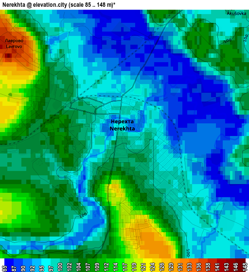
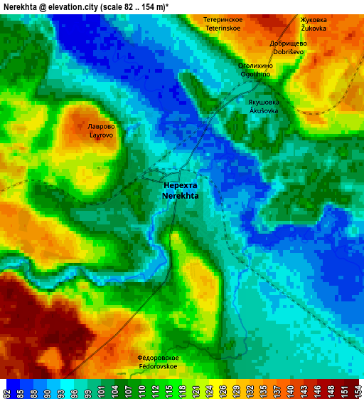
Below is the Elevation map of Nerekhta, which displays elevation range with different colors. Scale of the first map is from 85 to 148 m (279 to 486 ft) with average elevation of 100.5 meters (=330 ft) [note 1]
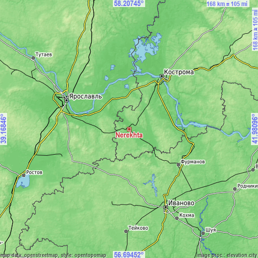
These maps also provides idea of topography and contour of this city, they are displayed at different zoom levels. More info about maps, scale and edge coordinates you can find below images.
| \ | Map #1 | Map #2 | Topo.Map |
| Scale [m] | 85..148 m | 82..154 m | × |
| Scale [ft] | 279..486 ft | 269..505 ft | × |
| Average | 100.5 m = 330 ft | 109 m = 358 ft | × |
| Width | 5.26 km = 3.3 mi | 10.51 km = 6.5 mi | 168.2 km = 104.5 mi |
| Height | 5.26 km = 3.3 mi | 10.51 km = 6.5 mi | 168.2 km = 104.5 mi |
| ↑Max Latitude | 57.482441° | 57.506056° | 58.20745° |
| Latitude at center | 57.45881° | 57.45881° | 57.45881° |
| ↓Min Latitude | 57.435164° | 57.411503° | 56.69452° |
| ← Min Longitude | 40.530765° | 40.486819° | 39.16846° |
| Longitude center | 40.57471° | 40.57471° | 40.57471° |
| →Max Longitude | 40.618655° | 40.662601° | 41.98096° |
Nearby cities:
Cities around Nerekhta sort by population:
• Kostroma elevation 109 m
40.1 km,  31°
31°
• Furmanov 125 m
39.3 km,  125°
125°
• Volgorechensk 114 m
34.8 km,  93°
93°
• Nekrasovskoye 104 m
27.2 km,  332°
332°
• Dubki 141 m
26.3 km,  227°
227°
• Burmakino 130 m
20.8 km,  256°
256°
• Tunoshna 90 m
28.5 km,  289°
289°
• Pistsovo 148 m
31.2 km,  184°
184°
• Kosmynino 137 m
17.8 km,  39°
39°
• Krasnyy Profintern 87 m
32.8 km,  345°
345°
• Dulyapino 132 m
26.6 km,  147°
147°
• Levashevo 128 m
20.9 km, 351°
Multilingual:
 En español:
Nerekhta elevación 93 m.
 En France:
Nerekhta élévation 93 m.


Sources and notes:
- [note 1] Map square and city borders are not equal. Map elevation data is calculated only from area inside that square.
- [src 1] Elevation data from geonames database provided with same terms of usage.
- [src 2] The elevation map of Nerekhta is generated using elevation data from NASA's 3 arcsec (90m) resolution SRTM data.
- [src 3] Base (background) map © OpenStreetMap contributors tiles are generated by Geofabrik and OpenTopoMap.
Copyright & License:
This Nerekhta Elevation Map is licensed under CC BY-SA. You may reuse any part from this page, if you give a proper credit by linking to this URL:
 More info on terms of use page.