Golynki elevation
Golynki (Smolensk), Russia elevation is 182 meters and Golynki elevation in feet is 597 ft above sea level [src 1]. Golynki is a populated place (feature code) with elevation that is 17 meters (56 ft) smaller than average city elevation in Russia.
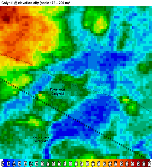
Below is the Elevation map of Golynki, which displays elevation range with different colors. Scale of the first map is from 172 to 200 m (564 to 656 ft) with average elevation of 180.3 meters (=592 ft) [note 1]
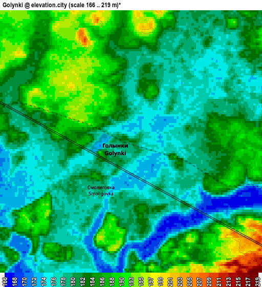
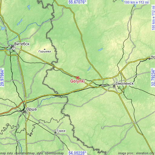
These maps also provides idea of topography and contour of this city, they are displayed at different zoom levels. More info about maps, scale and edge coordinates you can find below images.
| \ | Map #1 | Map #2 | Topo.Map |
| Scale [m] | 172..200 m | 166..219 m | × |
| Scale [ft] | 564..656 ft | 545..719 ft | × |
| Average | 180.3 m = 592 ft | 182.6 m = 599 ft | × |
| Width | 5.62 km = 3.5 mi | 11.25 km = 7 mi | 180 km = 111.8 mi |
| Height | 5.62 km = 3.5 mi | 11.25 km = 7 mi | 179.9 km = 111.8 mi |
| ↑Max Latitude | 54.89492° | 54.920184° | 55.67076° |
| Latitude at center | 54.86964° | 54.86964° | 54.86964° |
| ↓Min Latitude | 54.844344° | 54.819033° | 54.05228° |
| ← Min Longitude | 31.342145° | 31.298199° | 29.97984° |
| Longitude center | 31.38609° | 31.38609° | 31.38609° |
| →Max Longitude | 31.430035° | 31.473981° | 32.79234° |
Nearby cities:
Cities around Golynki sort by population:
• Smolensk elevation 250 m
43 km,  103°
103°
• Yartsevo 204 m
86.5 km,  75°
75°
• Rudnya 188 m
20.6 km,  294°
294°
• Pochinok 208 m
85.2 km,  127°
127°
• Demidov 159 m
45.3 km,  10°
10°
• Velizh 164 m
82.7 km,  351°
351°
• Kardymovo 195 m
66.9 km,  88°
88°
• Monastyrshchina 191 m
64.7 km,  153°
153°
• Dukhovshchina 217 m
74.5 km,  61°
61°
• Pechersk 249 m
41.3 km, 92°
• Katyn' 183 m
22.2 km,  118°
118°
• Talashkino 225 m
56.4 km, 115°
Multilingual:
 En español:
Golynki elevación 182 m.
 En France:
Golynki élévation 182 m.


Sources and notes:
- [note 1] Map square and city borders are not equal. Map elevation data is calculated only from area inside that square.
- [src 1] Elevation data from geonames database provided with same terms of usage.
- [src 2] The elevation map of Golynki is generated using elevation data from NASA's 3 arcsec (90m) resolution SRTM data.
- [src 3] Base (background) map © OpenStreetMap contributors tiles are generated by Geofabrik and OpenTopoMap.
Copyright & License:
This Golynki Elevation Map is licensed under CC BY-SA. You may reuse any part from this page, if you give a proper credit by linking to this URL:
 More info on terms of use page.