Grigoropolisskaya elevation
Grigoropolisskaya (Stavropol’ Kray), Russia elevation is 137 meters and Grigoropolisskaya elevation in feet is 449 ft above sea level [src 1]. Grigoropolisskaya is a populated place (feature code) with elevation that is 62 meters (203 ft) smaller than average city elevation in Russia.
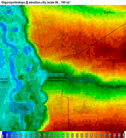
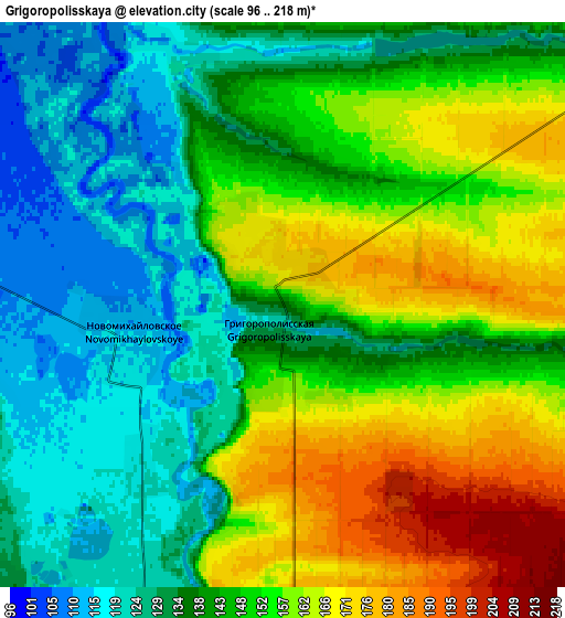
Below is the Elevation map of Grigoropolisskaya, which displays elevation range with different colors. Scale of the first map is from 96 to 189 m (315 to 620 ft) with average elevation of 145.9 meters (=479 ft) [note 1]
These maps also provides idea of topography and contour of this city, they are displayed at different zoom levels. More info about maps, scale and edge coordinates you can find below images.
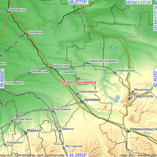
| \ | Map #1 | Map #2 | Topo.Map |
| Scale [m] | 96..189 m | 96..218 m | × |
| Scale [ft] | 315..620 ft | 315..715 ft | × |
| Average | 145.9 m = 479 ft | 145.8 m = 478 ft | × |
| Width | 6.87 km = 4.3 mi | 13.75 km = 8.5 mi | 220 km = 136.7 mi |
| Height | 6.87 km = 4.3 mi | 13.75 km = 8.5 mi | 220 km = 136.7 mi |
| ↑Max Latitude | 45.328124° | 45.359011° | 46.27779° |
| Latitude at center | 45.29722° | 45.29722° | 45.29722° |
| ↓Min Latitude | 45.266299° | 45.235361° | 44.29939° |
| ← Min Longitude | 41.012725° | 40.968779° | 39.65042° |
| Longitude center | 41.05667° | 41.05667° | 41.05667° |
| →Max Longitude | 41.100615° | 41.144561° | 42.46292° |
Nearby cities:
Cities around Grigoropolisskaya sort by population:
• Novokubansk elevation 143 m
20.2 km,  186°
186°
• Gul’kevichi 99 m
29 km,  282°
282°
• Novoaleksandrovsk 101 m
25.4 km,  30°
30°
• Temizhbekskaya 121 m
23.4 km,  314°
314°
• Prochnookopskaya 198 m
26.1 km,  169°
169°
• Ventsy 109 m
19.4 km,  297°
297°
• Maykopskoye 84 m
25.1 km, 295°
• Temizhbekskaya 149 m
17.1 km,  355°
355°
• Otrado-Kubanskoye 135 m
17.9 km,  250°
250°
• Kovalevskoye 142 m
13.1 km,  208°
208°
• Sokolovskoye 116 m
29.8 km,  261°
261°
• Krasnaya Polyana 155 m
27.2 km, 172°
Multilingual:
 En español:
Grigoropolisskaya elevación 137 m.
 En France:
Grigoropolisskaya élévation 137 m.
 Auf Deutsch:
Grigoropolisskaya höhe über dem Meeresspiegel ist 137 m.

Sources and notes:
- [note 1] Map square and city borders are not equal. Map elevation data is calculated only from area inside that square.
- [src 1] Elevation data from geonames database provided with same terms of usage.
- [src 2] The elevation map of Grigoropolisskaya is generated using elevation data from NASA's 3 arcsec (90m) resolution SRTM data.
- [src 3] Base (background) map © OpenStreetMap contributors tiles are generated by Geofabrik and OpenTopoMap.
Copyright & License:
This Grigoropolisskaya Elevation Map is licensed under CC BY-SA. You may reuse any part from this page, if you give a proper credit by linking to this URL:
 More info on terms of use page.