Temizhbekskaya elevation
Temizhbekskaya (Stavropol’ Kray), Russia elevation is 149 meters and Temizhbekskaya elevation in feet is 489 ft above sea level [src 1]. Temizhbekskaya is a populated place (feature code) with elevation that is 50 meters (164 ft) smaller than average city elevation in Russia.
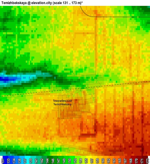
Below is the Elevation map of Temizhbekskaya, which displays elevation range with different colors. Scale of the first map is from 131 to 173 m (430 to 568 ft) with average elevation of 155.9 meters (=511 ft) [note 1]
These maps also provides idea of topography and contour of this city, they are displayed at different zoom levels. More info about maps, scale and edge coordinates you can find below images.
| \ | Map #1 | Map #2 | Topo.Map |
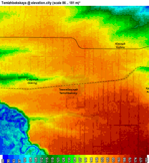
| Scale [m] | 131..173 m | 86..181 m | × |
| Scale [ft] | 430..568 ft | 282..594 ft | × |
| Average | 155.9 m = 511 ft | 148 m = 486 ft | × |
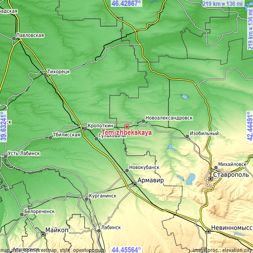
| Width | 6.86 km = 4.3 mi | 13.71 km = 8.5 mi | 219.4 km = 136.3 mi |
| Height | 6.86 km = 4.3 mi | 13.71 km = 8.5 mi | 219.4 km = 136.3 mi |
| ↑Max Latitude | 45.4816° | 45.512403° | 46.42867° |
| Latitude at center | 45.45078° | 45.45078° | 45.45078° |
| ↓Min Latitude | 45.419943° | 45.389089° | 44.45564° |
| ← Min Longitude | 40.994715° | 40.950769° | 39.63241° |
| Longitude center | 41.03866° | 41.03866° | 41.03866° |
| →Max Longitude | 41.082605° | 41.126551° | 42.44491° |
Nearby cities:
Cities around Temizhbekskaya sort by population:
• Gul’kevichi elevation 99 m
28.9 km,  248°
248°
• Novoaleksandrovsk 101 m
15 km,  70°
70°
• Kavkazskaya 138 m
28.3 km,  268°
268°
• Grigoropolisskaya 137 m
17.1 km,  175°
175°
• Girey 77 m
30.2 km,  259°
259°
• Temizhbekskaya 121 m
15.1 km, 267°
• Rasshevatskaya 85 m
13.8 km,  358°
358°
• Ventsy 109 m
17.9 km,  242°
242°
• Maykopskoye 84 m
22.2 km, 253°
• Otrado-Kubanskoye 135 m
27.7 km,  213°
213°
• Dmitriyevskaya 70 m
31.2 km,  317°
317°
• Kovalevskoye 142 m
28.9 km,  189°
189°
Multilingual:
 En español:
Temizhbekskaya elevación 149 m.
 En France:
Temizhbekskaya élévation 149 m.
 Auf Deutsch:
Temizhbekskaya höhe über dem Meeresspiegel ist 149 m.
 На русском:
Темижбекский, Темижбекская высота над уровнем моря 149 м
Sources and notes:
- [note 1] Map square and city borders are not equal. Map elevation data is calculated only from area inside that square.
- [src 1] Elevation data from geonames database provided with same terms of usage.
- [src 2] The elevation map of Temizhbekskaya is generated using elevation data from NASA's 3 arcsec (90m) resolution SRTM data.
- [src 3] Base (background) map © OpenStreetMap contributors tiles are generated by Geofabrik and OpenTopoMap.
Copyright & License:
This Temizhbekskaya Elevation Map is licensed under CC BY-SA. You may reuse any part from this page, if you give a proper credit by linking to this URL:
 More info on terms of use page.