Ignatovka elevation
Ignatovka (Ulyanovsk), Russia elevation is 183 meters and Ignatovka elevation in feet is 600 ft above sea level [src 1]. Ignatovka is a populated place (feature code) with elevation that is 16 meters (52 ft) smaller than average city elevation in Russia.
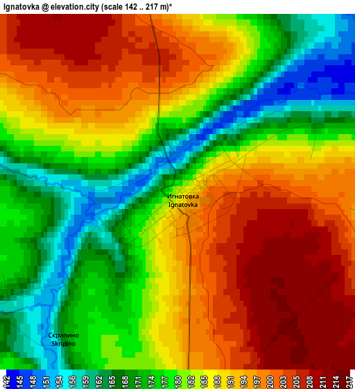
Below is the Elevation map of Ignatovka, which displays elevation range with different colors. Scale of the first map is from 142 to 217 m (466 to 712 ft) with average elevation of 185.2 meters (=608 ft) [note 1]
These maps also provides idea of topography and contour of this city, they are displayed at different zoom levels. More info about maps, scale and edge coordinates you can find below images.
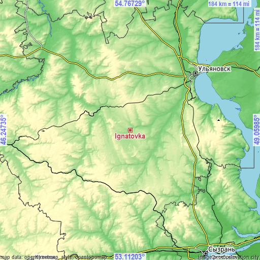
| \ | Map #1 | Topo.Map |
| Scale [m] | 142..217 m | × |
| Scale [ft] | 466..712 ft | × |
| Average | 185.2 m = 608 ft | × |
| Width | 5.75 km = 3.6 mi | 184 km = 114.3 mi |
| Height | 5.75 km = 3.6 mi | 184 km = 114.3 mi |
| ↑Max Latitude | 53.973725° | 54.76729° |
| Latitude at center | 53.94787° | 53.94787° |
| ↓Min Latitude | 53.921999° | 53.11203° |
| ← Min Longitude | 47.609655° | 46.24735° |
| Longitude center | 47.6536° | 47.6536° |
| →Max Longitude | 47.697545° | 49.05985° |
Nearby cities:
Cities around Ignatovka sort by population:
• Barysh elevation 173 m
48.2 km,  227°
227°
• Novoul’yanovsk 99 m
53 km,  64°
64°
• Kuzovatovo 221 m
44.6 km,  177°
177°
• Karsun 161 m
51.9 km,  302°
302°
• Mayna 278 m
18.5 km,  353°
353°
• Veshkayma 287 m
36 km,  287°
287°
• Yazykovo 167 m
42 km,  335°
335°
• Starotimoshkino 171 m
26.7 km,  197°
197°
• Silikatnyy 284 m
44.3 km,  83°
83°
• Krasnyy Gulyay 252 m
45.3 km, 78°
• Izmaylovo 200 m
36.8 km, 226°
• Chufarovo 137 m
26.5 km,  308°
308°
Multilingual:
 En español:
Ignatovka elevación 183 m.
 En France:
Ignatovka élévation 183 m.
 Auf Deutsch:
Ignatovka höhe über dem Meeresspiegel ist 183 m.

Sources and notes:
- [note 1] Map square and city borders are not equal. Map elevation data is calculated only from area inside that square.
- [src 1] Elevation data from geonames database provided with same terms of usage.
- [src 2] The elevation map of Ignatovka is generated using elevation data from NASA's 3 arcsec (90m) resolution SRTM data.
- [src 3] Base (background) map © OpenStreetMap contributors tiles are generated by Geofabrik and OpenTopoMap.
Copyright & License:
This Ignatovka Elevation Map is licensed under CC BY-SA. You may reuse any part from this page, if you give a proper credit by linking to this URL:
 More info on terms of use page.