Kuzovatovo elevation
Kuzovatovo (Ulyanovsk), Russia elevation is 221 meters and Kuzovatovo elevation in feet is 725 ft above sea level [src 1]. Kuzovatovo is a populated place (feature code) with elevation that is 22 meters (72 ft) bigger than average city elevation in Russia.
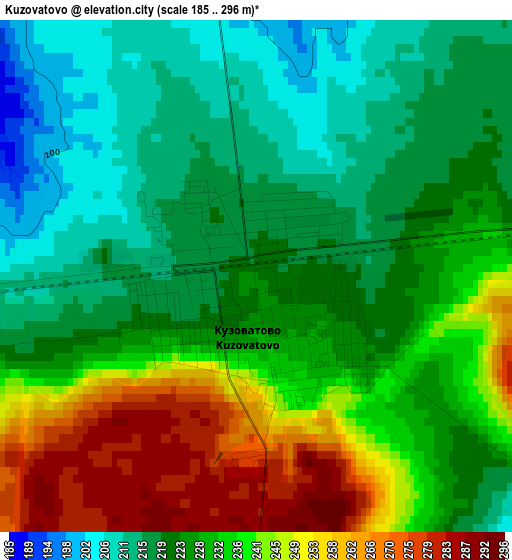
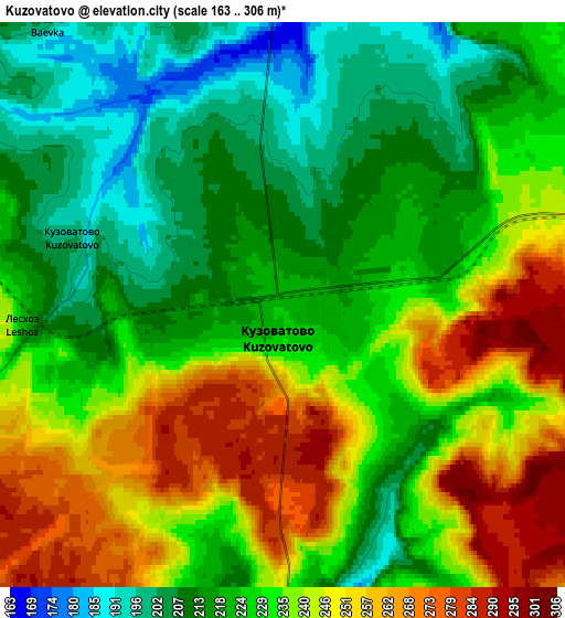
Below is the Elevation map of Kuzovatovo, which displays elevation range with different colors. Scale of the first map is from 185 to 296 m (607 to 971 ft) with average elevation of 230 meters (=755 ft) [note 1]
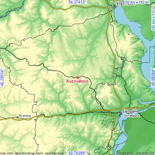
These maps also provides idea of topography and contour of this city, they are displayed at different zoom levels. More info about maps, scale and edge coordinates you can find below images.
| \ | Map #1 | Map #2 | Topo.Map |
| Scale [m] | 185..296 m | 163..306 m | × |
| Scale [ft] | 607..971 ft | 535..1004 ft | × |
| Average | 230 m = 755 ft | 230.4 m = 756 ft | × |
| Width | 5.81 km = 3.6 mi | 11.61 km = 7.2 mi | 185.8 km = 115.5 mi |
| Height | 5.81 km = 3.6 mi | 11.61 km = 7.2 mi | 185.8 km = 115.5 mi |
| ↑Max Latitude | 53.572913° | 53.598999° | 54.37413° |
| Latitude at center | 53.54681° | 53.54681° | 53.54681° |
| ↓Min Latitude | 53.520691° | 53.494556° | 52.70299° |
| ← Min Longitude | 47.642645° | 47.598699° | 46.28034° |
| Longitude center | 47.68659° | 47.68659° | 47.68659° |
| →Max Longitude | 47.730535° | 47.774481° | 49.09284° |
Nearby cities:
Cities around Kuzovatovo sort by population:
• Barysh elevation 173 m
39.8 km,  287°
287°
• Novospasskoye 71 m
44.7 km,  174°
174°
• Nikolayevka 131 m
56.7 km,  214°
214°
• Pavlovka 257 m
61 km,  275°
275°
• Starotimoshkino 171 m
21.7 km,  331°
331°
• Varlamovo 89 m
62.9 km,  129°
129°
• Balasheyka 169 m
39.4 km,  137°
137°
• Izmaylovo 200 m
34.9 km,  303°
303°
• Imeni Vladimira Il’icha Lenina 209 m
46.7 km,  272°
272°
• Ignatovka 183 m
44.6 km,  357°
357°
• Zhadovka 197 m
48.8 km, 273°
• Kanadey 97 m
43.5 km,  194°
194°
Multilingual:
 En español:
Kuzovatovo elevación 221 m.
 En France:
Kuzovatovo élévation 221 m.
 Auf Deutsch:
Kuzovatovo höhe über dem Meeresspiegel ist 221 m.

Sources and notes:
- [note 1] Map square and city borders are not equal. Map elevation data is calculated only from area inside that square.
- [src 1] Elevation data from geonames database provided with same terms of usage.
- [src 2] The elevation map of Kuzovatovo is generated using elevation data from NASA's 3 arcsec (90m) resolution SRTM data.
- [src 3] Base (background) map © OpenStreetMap contributors tiles are generated by Geofabrik and OpenTopoMap.
Copyright & License:
This Kuzovatovo Elevation Map is licensed under CC BY-SA. You may reuse any part from this page, if you give a proper credit by linking to this URL:
 More info on terms of use page.