Isakly elevation
Isakly (Samara Oblast), Russia elevation is 77 meters and Isakly elevation in feet is 253 ft above sea level [src 1]. Isakly is a populated place (feature code) with elevation that is 122 meters (400 ft) smaller than average city elevation in Russia.
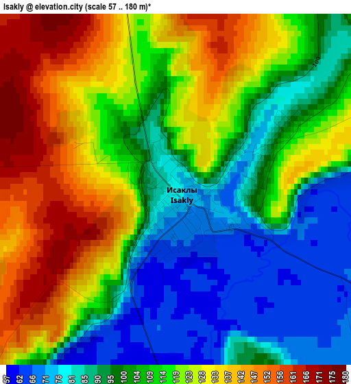
Below is the Elevation map of Isakly, which displays elevation range with different colors. Scale of the first map is from 57 to 180 m (187 to 591 ft) with average elevation of 110.5 meters (=363 ft) [note 1]
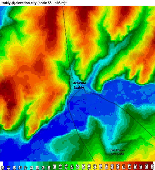
These maps also provides idea of topography and contour of this city, they are displayed at different zoom levels. More info about maps, scale and edge coordinates you can find below images.
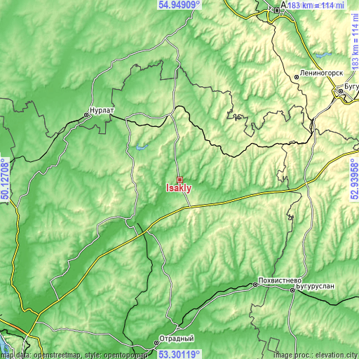
| \ | Map #1 | Map #2 | Topo.Map |
| Scale [m] | 57..180 m | 55..198 m | × |
| Scale [ft] | 187..591 ft | 180..650 ft | × |
| Average | 110.5 m = 363 ft | 120.2 m = 394 ft | × |
| Width | 5.73 km = 3.6 mi | 11.45 km = 7.1 mi | 183.2 km = 113.8 mi |
| Height | 5.73 km = 3.6 mi | 11.45 km = 7.1 mi | 183.2 km = 113.8 mi |
| ↑Max Latitude | 54.15907° | 54.184793° | 54.94909° |
| Latitude at center | 54.13333° | 54.13333° | 54.13333° |
| ↓Min Latitude | 54.107574° | 54.081803° | 53.30119° |
| ← Min Longitude | 51.489385° | 51.445439° | 50.12708° |
| Longitude center | 51.53333° | 51.53333° | 51.53333° |
| →Max Longitude | 51.577275° | 51.621221° | 52.93958° |
Nearby cities:
Cities around Isakly sort by population:
• Nurlat elevation 156 m
57.5 km,  304°
304°
• Pokhvistnevo 69 m
66.1 km,  143°
143°
• Sukhodol 87 m
33.3 km,  219°
219°
• Shentala 240 m
35.4 km,  354°
354°
• Klyavlino 241 m
35.3 km,  65°
65°
• Chelno-Vershiny 145 m
42.7 km,  317°
317°
• Cheremshan 139 m
59.3 km,  357°
357°
• Kamyshla 140 m
39.7 km,  92°
92°
• Surgut 75 m
31.6 km, 222°
• Severnoye 197 m
66 km, 93°
• Sernovodsk 92 m
29.5 km, 217°
• Shugurovo 129 m
57 km,  42°
42°
Multilingual:
 En español:
Isakly elevación 77 m.
 En France:
Isakly élévation 77 m.


Sources and notes:
- [note 1] Map square and city borders are not equal. Map elevation data is calculated only from area inside that square.
- [src 1] Elevation data from geonames database provided with same terms of usage.
- [src 2] The elevation map of Isakly is generated using elevation data from NASA's 3 arcsec (90m) resolution SRTM data.
- [src 3] Base (background) map © OpenStreetMap contributors tiles are generated by Geofabrik and OpenTopoMap.
Copyright & License:
This Isakly Elevation Map is licensed under CC BY-SA. You may reuse any part from this page, if you give a proper credit by linking to this URL:
 More info on terms of use page.