Nurlat elevation
Nurlat (Tatarstan Republic, Nurlatskiy Rayon), Russia elevation is 156 meters and Nurlat elevation in feet is 512 ft above sea level [src 1]. Nurlat is a populated place (feature code) with elevation that is 43 meters (141 ft) smaller than average city elevation in Russia.
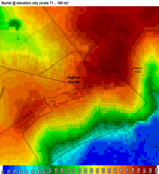
Below is the Elevation map of Nurlat, which displays elevation range with different colors. Scale of the first map is from 71 to 169 m (233 to 554 ft) with average elevation of 132.5 meters (=435 ft) [note 1]
These maps also provides idea of topography and contour of this city, they are displayed at different zoom levels. More info about maps, scale and edge coordinates you can find below images.
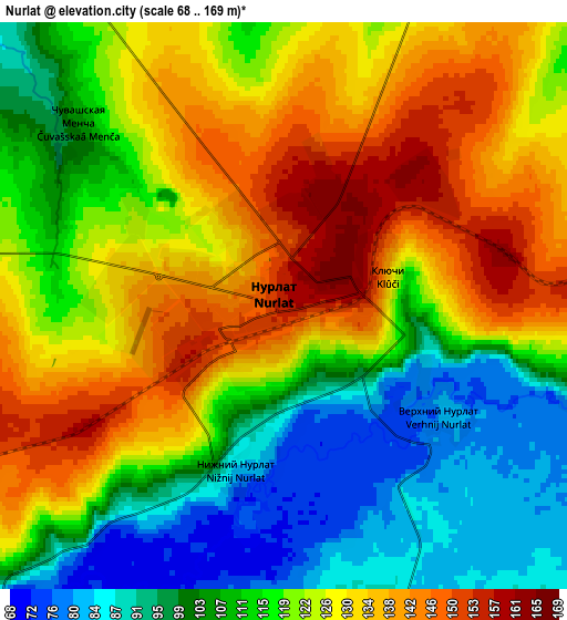
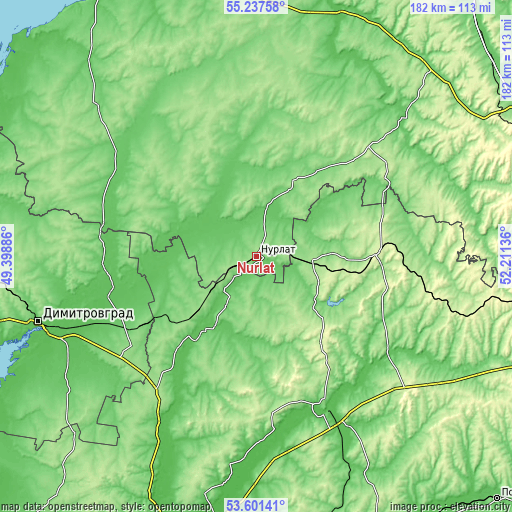
| \ | Map #1 | Map #2 | Topo.Map |
| Scale [m] | 71..169 m | 68..169 m | × |
| Scale [ft] | 233..554 ft | 223..554 ft | × |
| Average | 132.5 m = 435 ft | 119.3 m = 391 ft | × |
| Width | 5.68 km = 3.5 mi | 11.37 km = 7.1 mi | 181.9 km = 113 mi |
| Height | 5.68 km = 3.5 mi | 11.37 km = 7.1 mi | 181.9 km = 113 mi |
| ↑Max Latitude | 54.453216° | 54.478757° | 55.23758° |
| Latitude at center | 54.42766° | 54.42766° | 54.42766° |
| ↓Min Latitude | 54.402088° | 54.376499° | 53.60141° |
| ← Min Longitude | 50.761165° | 50.717219° | 49.39886° |
| Longitude center | 50.80511° | 50.80511° | 50.80511° |
| →Max Longitude | 50.849055° | 50.893001° | 52.21136° |
Nearby cities:
Cities around Nurlat sort by population:
• Sukhodol elevation 87 m
64.3 km,  155°
155°
• Koshki 113 m
32.7 km,  222°
222°
• Shentala 240 m
43.9 km,  86°
86°
• Chelno-Vershiny 145 m
18.2 km, 94°
• Cheremshan 139 m
52.1 km,  59°
59°
• Surgut 75 m
61.6 km, 155°
• Isakly 77 m
57.5 km,  124°
124°
• Sernovodsk 92 m
63.4 km,  152°
152°
• Novocheremshansk 68 m
42.1 km,  259°
259°
• Novaya Malykla 76 m
61 km,  245°
245°
• Yelkhovka 61 m
71 km,  208°
208°
• Bilyarsk 107 m
67.4 km,  336°
336°
Multilingual:
 En español:
Nurlat elevación 156 m.
 En France:
Nourlat élévation 156 m.


Sources and notes:
- [note 1] Map square and city borders are not equal. Map elevation data is calculated only from area inside that square.
- [src 1] Elevation data from geonames database provided with same terms of usage.
- [src 2] The elevation map of Nurlat is generated using elevation data from NASA's 3 arcsec (90m) resolution SRTM data.
- [src 3] Base (background) map © OpenStreetMap contributors tiles are generated by Geofabrik and OpenTopoMap.
Copyright & License:
This Nurlat Elevation Map is licensed under CC BY-SA. You may reuse any part from this page, if you give a proper credit by linking to this URL:
 More info on terms of use page.