Kambarka elevation
Kambarka (Udmurtiya Republic), Russia elevation is 78 meters and Kambarka elevation in feet is 256 ft above sea level [src 1]. Kambarka is a populated place (feature code) with elevation that is 121 meters (397 ft) smaller than average city elevation in Russia.
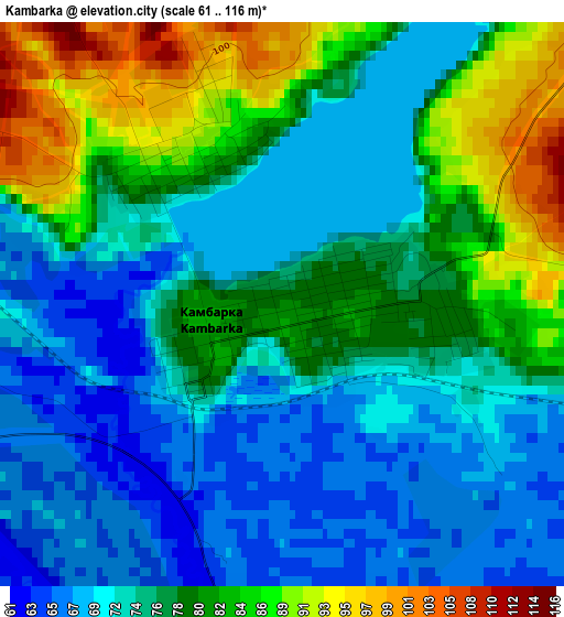
Below is the Elevation map of Kambarka, which displays elevation range with different colors. Scale of the first map is from 61 to 116 m (200 to 381 ft) with average elevation of 76.7 meters (=252 ft) [note 1]
These maps also provides idea of topography and contour of this city, they are displayed at different zoom levels. More info about maps, scale and edge coordinates you can find below images.
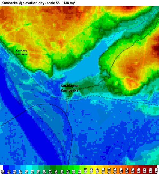
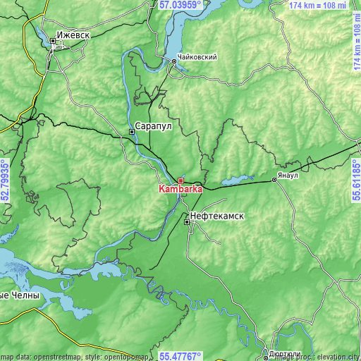
| \ | Map #1 | Map #2 | Topo.Map |
| Scale [m] | 61..116 m | 58..138 m | × |
| Scale [ft] | 200..381 ft | 190..453 ft | × |
| Average | 76.7 m = 252 ft | 81.4 m = 267 ft | × |
| Width | 5.43 km = 3.4 mi | 10.85 km = 6.7 mi | 173.7 km = 107.9 mi |
| Height | 5.43 km = 3.4 mi | 10.85 km = 6.7 mi | 173.7 km = 107.9 mi |
| ↑Max Latitude | 56.290996° | 56.315377° | 57.03959° |
| Latitude at center | 56.2666° | 56.2666° | 56.2666° |
| ↓Min Latitude | 56.242188° | 56.217761° | 55.47767° |
| ← Min Longitude | 54.161655° | 54.117709° | 52.79935° |
| Longitude center | 54.2056° | 54.2056° | 54.2056° |
| →Max Longitude | 54.249545° | 54.293491° | 55.61185° |
Nearby cities:
Cities around Kambarka sort by population:
• Neftekamsk elevation 108 m
19.8 km,  169°
169°
• Sarapul 117 m
34.3 km,  312°
312°
• Chaykovskiy 89 m
56.1 km,  354°
354°
• Yanaul 99 m
45 km,  88°
88°
• Agidel’ 82 m
43.3 km,  202°
202°
• Nikolo-Berëzovka 70 m
16.1 km,  191°
191°
• Sigayevo 86 m
31.6 km,  303°
303°
• Karakulino 112 m
41.9 km,  227°
227°
• Amzya 68 m
11.6 km,  107°
107°
• Kaltasy 126 m
49.7 km,  131°
131°
• Foki 137 m
48.2 km,  10°
10°
• Kama 74 m
8.1 km, 301°
Multilingual:
 En español:
Kambarka elevación 78 m.
 En France:
Kambarka élévation 78 m.


Sources and notes:
- [note 1] Map square and city borders are not equal. Map elevation data is calculated only from area inside that square.
- [src 1] Elevation data from geonames database provided with same terms of usage.
- [src 2] The elevation map of Kambarka is generated using elevation data from NASA's 3 arcsec (90m) resolution SRTM data.
- [src 3] Base (background) map © OpenStreetMap contributors tiles are generated by Geofabrik and OpenTopoMap.
Copyright & License:
This Kambarka Elevation Map is licensed under CC BY-SA. You may reuse any part from this page, if you give a proper credit by linking to this URL:
 More info on terms of use page.