Kanash elevation
Kanash (Chuvashia), Russia elevation is 196 meters and Kanash elevation in feet is 643 ft above sea level [src 1]. Kanash is a populated place (feature code) with elevation that is 3 meters (10 ft) smaller than average city elevation in Russia.
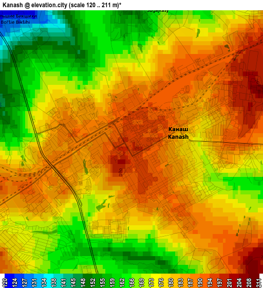
Below is the Elevation map of Kanash, which displays elevation range with different colors. Scale of the first map is from 120 to 211 m (394 to 692 ft) with average elevation of 176.8 meters (=580 ft) [note 1]
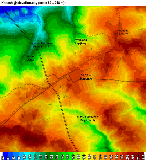
These maps also provides idea of topography and contour of this city, they are displayed at different zoom levels. More info about maps, scale and edge coordinates you can find below images.
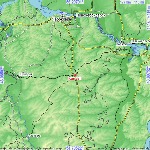
| \ | Map #1 | Map #2 | Topo.Map |
| Scale [m] | 120..211 m | 82..218 m | × |
| Scale [ft] | 394..692 ft | 269..715 ft | × |
| Average | 176.8 m = 580 ft | 169.4 m = 556 ft | × |
| Width | 5.53 km = 3.4 mi | 11.07 km = 6.9 mi | 177.1 km = 110 mi |
| Height | 5.53 km = 3.4 mi | 11.07 km = 6.9 mi | 177.1 km = 110 mi |
| ↑Max Latitude | 55.534497° | 55.559358° | 56.29791° |
| Latitude at center | 55.50962° | 55.50962° | 55.50962° |
| ↓Min Latitude | 55.484727° | 55.459819° | 54.70522° |
| ← Min Longitude | 47.447325° | 47.403379° | 46.08502° |
| Longitude center | 47.49127° | 47.49127° | 47.49127° |
| →Max Longitude | 47.535215° | 47.579161° | 48.89752° |
Nearby cities:
Cities around Kanash sort by population:
• Tsivil’sk elevation 67 m
40 km,  358°
358°
• Vurnary 171 m
33.2 km,  266°
266°
• Ibresi 191 m
36.8 km,  230°
230°
• Urmary 159 m
34.1 km,  56°
56°
• Batyrevo 102 m
49.7 km,  171°
171°
• Komsomol'skoye 118 m
28.3 km, 172°
• Krasnoarmeyskoye 109 m
35 km,  325°
325°
• Atlashevo 72 m
56 km,  4°
4°
• Yantikovo 97 m
43.5 km,  37°
37°
• Shikhazany 94 m
8.4 km,  312°
312°
• Alikovo 171 m
52.8 km,  298°
298°
• Buinsk 164 m
44.3 km,  217°
217°
Multilingual:
 En español:
Kanash elevación 196 m.
 En France:
Kanach élévation 196 m.


Sources and notes:
- [note 1] Map square and city borders are not equal. Map elevation data is calculated only from area inside that square.
- [src 1] Elevation data from geonames database provided with same terms of usage.
- [src 2] The elevation map of Kanash is generated using elevation data from NASA's 3 arcsec (90m) resolution SRTM data.
- [src 3] Base (background) map © OpenStreetMap contributors tiles are generated by Geofabrik and OpenTopoMap.
Copyright & License:
This Kanash Elevation Map is licensed under CC BY-SA. You may reuse any part from this page, if you give a proper credit by linking to this URL:
 More info on terms of use page.