Urmary elevation
Urmary (Chuvashia), Russia elevation is 159 meters and Urmary elevation in feet is 522 ft above sea level [src 1]. Urmary is a populated place (feature code) with elevation that is 40 meters (131 ft) smaller than average city elevation in Russia.
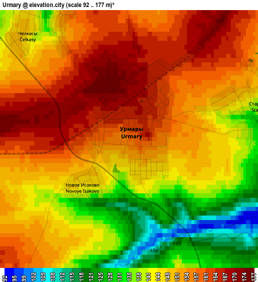
Below is the Elevation map of Urmary, which displays elevation range with different colors. Scale of the first map is from 92 to 177 m (302 to 581 ft) with average elevation of 148.6 meters (=488 ft) [note 1]
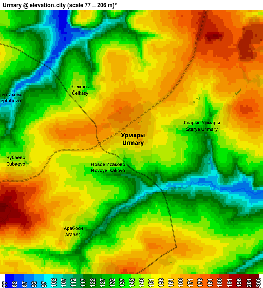
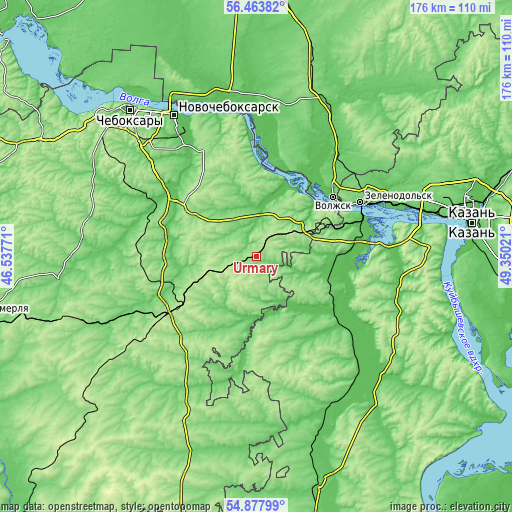
These maps also provides idea of topography and contour of this city, they are displayed at different zoom levels. More info about maps, scale and edge coordinates you can find below images.
| \ | Map #1 | Map #2 | Topo.Map |
| Scale [m] | 92..177 m | 77..206 m | × |
| Scale [ft] | 302..581 ft | 253..676 ft | × |
| Average | 148.6 m = 488 ft | 147.3 m = 483 ft | × |
| Width | 5.51 km = 3.4 mi | 11.02 km = 6.8 mi | 176.3 km = 109.5 mi |
| Height | 5.51 km = 3.4 mi | 11.02 km = 6.8 mi | 176.3 km = 109.5 mi |
| ↑Max Latitude | 55.70371° | 55.728464° | 56.46382° |
| Latitude at center | 55.67894° | 55.67894° | 55.67894° |
| ↓Min Latitude | 55.654154° | 55.629353° | 54.87799° |
| ← Min Longitude | 47.900015° | 47.856069° | 46.53771° |
| Longitude center | 47.94396° | 47.94396° | 47.94396° |
| →Max Longitude | 47.987905° | 48.031851° | 49.35021° |
Nearby cities:
Cities around Urmary sort by population:
• Zelenodolsk elevation 104 m
40.3 km,  62°
62°
• Volzhsk 60 m
33.3 km,  51°
51°
• Kanash 196 m
34.1 km,  236°
236°
• Tsivil’sk 67 m
36 km,  306°
306°
• Zvenigovo 69 m
33.2 km,  7°
7°
• Kozlovka 73 m
26.4 km, 46°
• Nizhniye Vyazovyye 61 m
38.7 km,  69°
69°
• Privolzhskiy 93 m
43 km,  43°
43°
• Atlashevo 72 m
44.3 km,  326°
326°
• Yantikovo 97 m
16 km,  352°
352°
• Shikhazany 94 m
37 km,  249°
249°
• Pomary 81 m
41 km, 38°
Multilingual:
 En español:
Urmary elevación 159 m.
 En France:
Urmary élévation 159 m.


Sources and notes:
- [note 1] Map square and city borders are not equal. Map elevation data is calculated only from area inside that square.
- [src 1] Elevation data from geonames database provided with same terms of usage.
- [src 2] The elevation map of Urmary is generated using elevation data from NASA's 3 arcsec (90m) resolution SRTM data.
- [src 3] Base (background) map © OpenStreetMap contributors tiles are generated by Geofabrik and OpenTopoMap.
Copyright & License:
This Urmary Elevation Map is licensed under CC BY-SA. You may reuse any part from this page, if you give a proper credit by linking to this URL:
 More info on terms of use page.